One-sentence summary
A significant storm is likely this weekend along the East Coast, but there are a number of complexities to it that will determine who sees snow, a mix, or mostly rain.
What’s happening?
As we jump start 2024, the weather pattern will begin to kick into high gear, bringing storminess, not atypical for an El Nino winter. What I want to do in this post is table set what’s happening, and what it may or may not mean. Social media has been ripe with speculation over everything between snowstorms in the Northeast Corridor to sudden stratospheric warming events that can potentially lead to a weather pattern conducive to cold and snow. What should we actually be watching? Let’s jump in.
Through Friday
Nationally, things look mostly quiet through the end of the week, with some rain and mountain snow in the West, and at least some widespread rain over the Southeast or Gulf Coast from a quick moving system.
Weekend storm
A storm on Thursday will get going over the Rockies and emerge into Texas on Friday, delivering some widespread rain and at least a slight chance of strong to severe storms on the Gulf Coast. By Saturday evening, there is good agreement that low pressure will be centered near the East Coast between Delmarva and the Outer Banks of North Carolina.
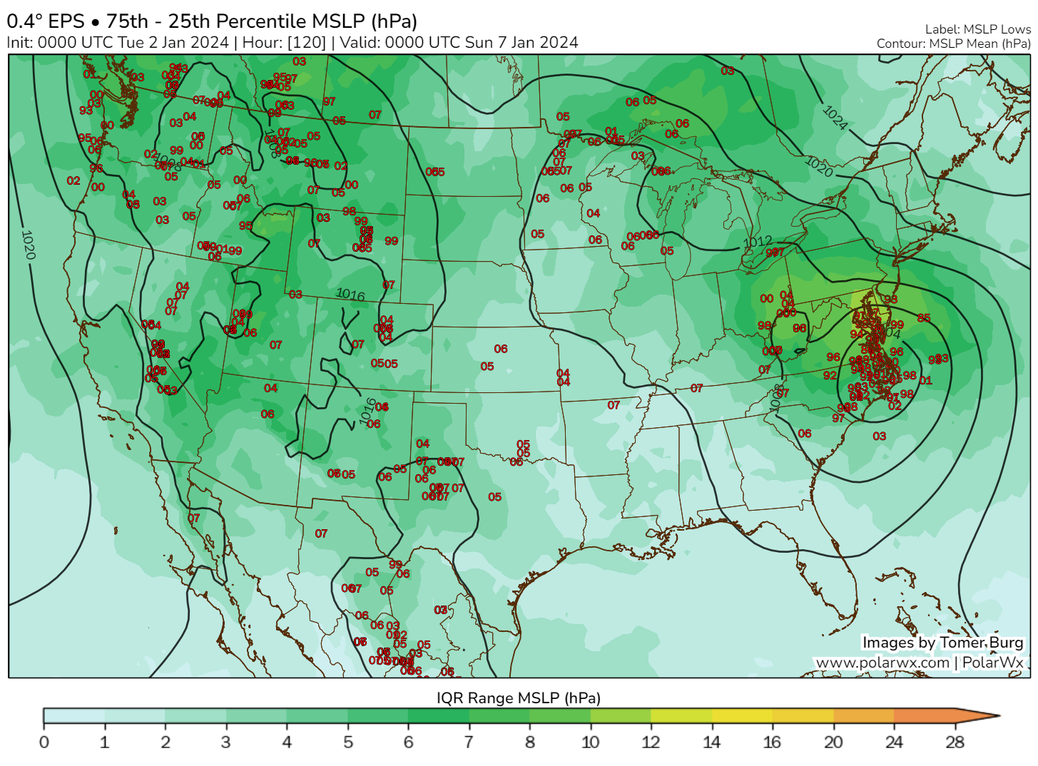
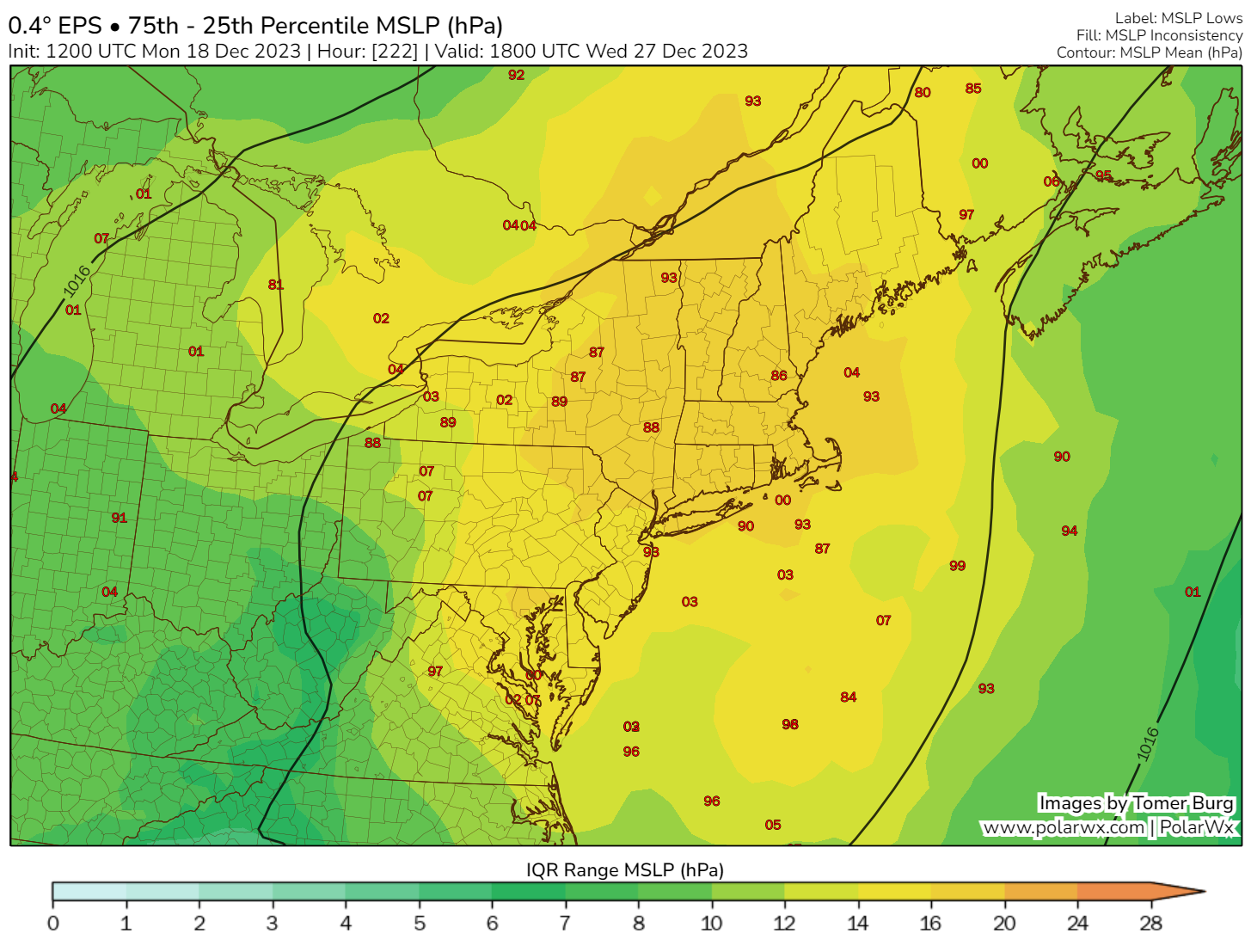
There is still a considerable spread in details and specifics based on that. But we can look at this and make some assumptions. Let’s roll it forward to Sunday morning. When we talk about Northeast storms, you’ll occasionally hear reference to “the Benchmark.” The Benchmark refers to the 40 degree latitude/70 degree longitude point south of New England. In general, when storms track near this point, it’s a favorable setup for snow in the Northeast Megalopolis (Boston-DC). There are a lot of other factors that play into this, but if you want an old school, quick and dirty idea of snow chances, that’s about as good as you can do. So on Sunday morning, this storm tracks, broadly, toward the Benchmark.
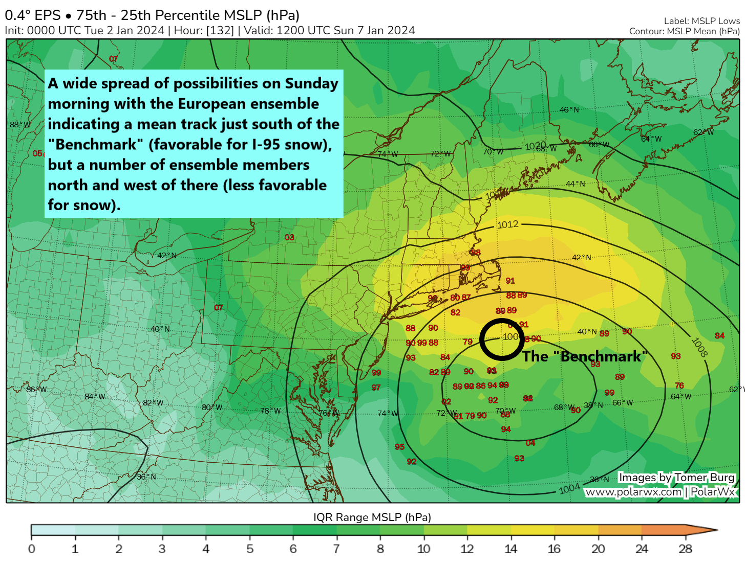
So the European ensemble shows a number of storm tracks on either side of the Benchmark with several rather close to the coast. This means uncertainty is high. Let’s ask the next question. Is cold air available? The answer is…not entirely.
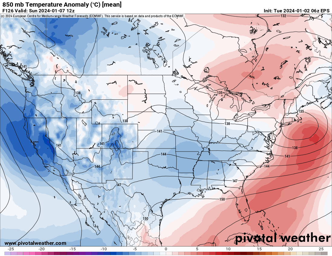
The air may be cold enough for snow, but there’s a lack of any real Arctic air, a lack of colder than normal air, and a storm track that’s tenuously close to the Benchmark. This does not give me warm and fuzzies for I-95 or coastal snow. You can see this reflected in European model probabilities of 3 inches or more snow (what I would deem “plowable” snow).
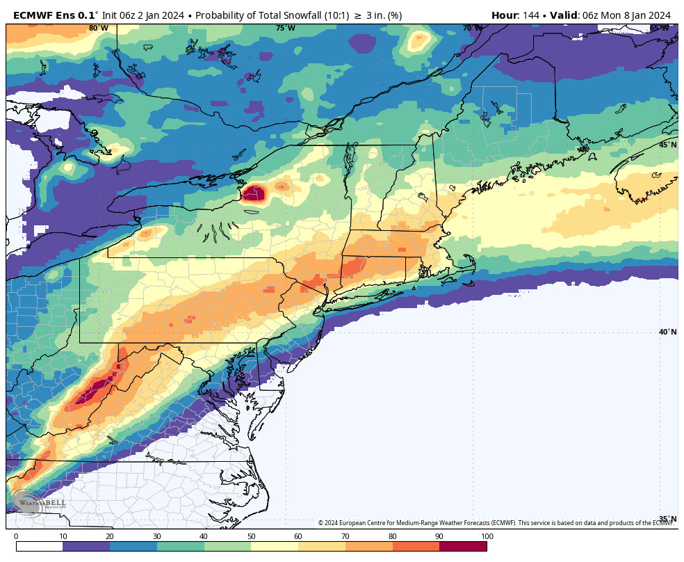
Odds of 3″ or more snow are currently sitting around 60 to 80 percent in much of New England, around 50 to 60 percent in New York City, and around 40 to 50 percent in Philly. You can see some lollipops of higher odds in the mountains of West Virginia through Pennsylvania, New Jersey, just south of the Catskills, and the Litchfield Hills in Connecticut.
What this says to me, as someone who grew up with this stuff: Probably a thump of snow, mixing with and changing to rain, then perhaps ending as snow for DC, Philly, and New York. For New England, it’s a lot more complex. The current “mean” storm track is definitely favorable for snow there, but a track on the other side of the Benchmark would probably put severe pressure on meager cold air and increase mixing chances.
The bottom line: I worry about the finer details here, but in general it looks like a winter storm is coming for someone. But if I lived from NYC to DC, I’d keep my expectations in check. This has the feel of a “north and west” event. I’d feel better about snow in New England.
What’s next?
Beyond this storm, there appears that another, potentially bigger storm will arrive around Tuesday or Wednesday of next week. This one looks likely to be an inland cutter, meaning it will track across the Great Lakes or up the Appalachian spine. But this has potential to be a significant snowstorm or mixed precip event in the Midwest next week.

Folks in the Midwest and East should watch this one closely for both heavy snow and heavy rain. A continued active pattern seems likely in the coming weeks. Stay tuned!