Happy Friday! Congratulations, we made it through the week without a named storm. Let’s do it again next week. There’s not a lot new to add forecast-wise today, so we’ll keep it brief and then tie together all the threads of our seasonal outlook below. Next week, we’ll touch on dust, and look for a bit of a longer-form piece on the spate of recent major hurricanes in the Gulf of Mexico and what it does or does not tell us about the future. A lot of effort went into that and I think it’s important to understand, so I hope you’ll check it out next week.
Meanwhile, be sure to give our social feeds a follow on the right (or bottom on mobile) and spread the word to your family and friends on the East Coast, Gulf Coast, Atlantic Canada, Caribbean, or Central America!
One-sentence summary
No tropical development is expected over the next seven to ten days.
Happening now: All’s quiet
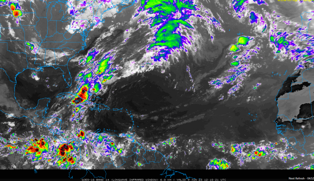
Take a quick peak at the satellite image across the Atlantic basin, and while it’s definitely not quiet, there is nothing of note anywhere out there, as you expect in June.

The medium range (days 6-10): Still nothing
We continue to watch for activity to get a little more interesting late, but through day 10 at least, there’s nothing to really speak of out there.
Fantasyland (beyond day 10): No change in thinking
We explained yesterday in some detail why we did not believe the operational GFS model. We continue to hold those truths to be self-evident today.
Tying together the seasonal outlook: “Average” is the path of least resistance
On Tuesday we talked about the various seasonal forecasts from different government, private sector, and academic institutions. On Wednesday we noted how El Niño makes a convincing case for a quieter hurricane season. But yesterday we noted how the Atlantic Ocean was in a condition that typically correlates with very active seasons.
So what do we make of all this?
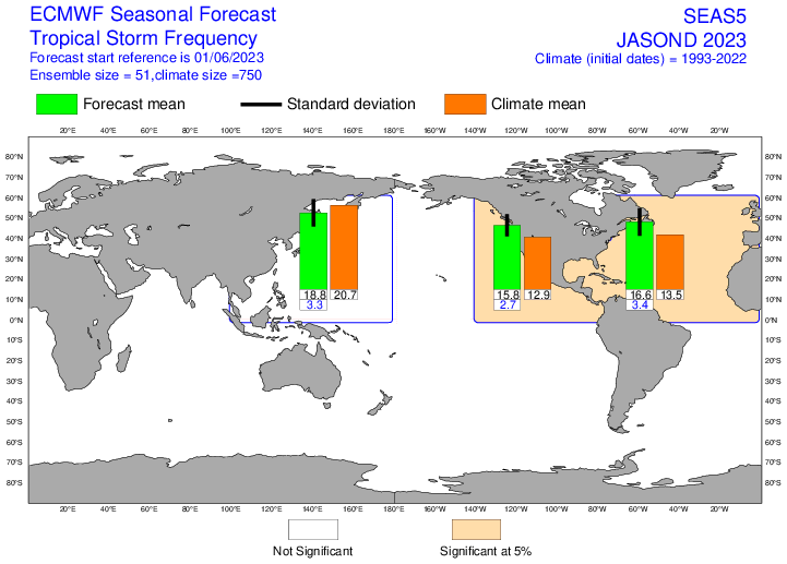
Well, yesterday, NOAA declared that we’re officially in an El Niño now. This gives us a bit of confidence that we’re going to maintain at least a weak, if not a moderate El Niño (or stronger) through the peak of hurricane season. The wind shear imparted on the Atlantic by El Niño is a tough barrier to get past. It would be difficult to expect an active hurricane season given El Niño. But given the setup in the Atlantic, it seems difficult to expect this season to behave quite as quietly as past El Niño seasons. One need only look at the European model forecast for the season to see this.

It calls for an above average hurricane season. It says, to heck with El Niño, the Atlantic is blazing, let’s rev it up! I think it’s notable to look back to last year in June, however. The ECMWF was also calling for a very active season (as were most of us), and that did not materialize. Last year was “average” statistically.
So given all this, I call forecasting an average season the path of least resistance. What I ultimately think could happen is that the Caribbean struggles due to shear, the eastern Atlantic is very busy, and the most concerning items this season will be systems close to home that form when wind shear relaxes some, possibly off the Southeast and in the Gulf. I believe it will be tough to relax shear enough this season to produce the ultra high-end storms we’ve seen in recent years, but that’s completely speculative on my part. We’ve also seen some instances in recent years where shear has actually helped some storms along, depending on where exactly it was placed. So never say never.
Back on Tuesday I said that the consensus forecast (16 storms, 7 hurricanes, 3 major hurricanes) was as good a forecast as you could offer right now. I stand by that, with perhaps slightly higher odds for a little under those hurricane/major hurricane numbers.
As always, prepare for the season the same way you would if we told you it was be insanely active, which is to say: Know your zone, have a plan, build a kit.
Enjoy the weekend. We’ll be back with you again Monday!
Loving this stuff Matt! thanks for all you do!!
Your stuff is great! Your voice of reason sets a good tone for the day 😀
Tysm! 🌻
Great job guys, thank you for leaving the bs, (sorry for that)out of forecasting.
I am so thankful you all have put this site together. I already follow Space City Weather even though I live just outside of Beaumont. The forecasting you all provide really helps calm my disaster-weary nerves. Straight to the facts with a clear explanation of what it says and why it says it, and years of experience to back it up. You all are a breath of fresh air in the quagmire of ridiculous clickbait that’s out there.
Just so we’re “prepared”, what is the Florida (and other coastal states) equivalent of Katy?
I recommend you use your favorite online map to make your own determination (especially as the analog will vary from one location to another). For reference, Katy, TX is about 30 miles due west of downtown Houston, about 65 miles from the coast as the crow flies, and about 70 miles WNW from Galveston, TX. Elevation of Katy is 140 feet above sea level. Taken in drive times, at highway speeds (meaning without heavy traffic), Katy is about an hour and a half drive from the coast. If you happen to be asking because of the SCW app Settings -> Notifications setting for “Evacuate Katy”, that is a humorous way of saying “we are in really deep trouble”. (I fully expect that notification will never actually be needed. But I do love it for the humor.)
You’ve given this thought…I am impressed! See my answer to Jim…I lean toward Philly here. 🙂
Ha…among weather folk, the Northeast or Mid-Atlantic equivalent of that I’ve found is probably “How much for Philly?” Basically, it harkens back to message boards when someone would explain why a coastal storm in winter would or would not happen, and inevitably, someone would basically be like “Yeah, but how much for Philly?” I can’t speak for Florida or the Southeast though ha. But I fully endorse the How much for Philly play.