August 21, 2023 Outlook: Gulf tropical wave chugs west toward South Texas; TS Franklin to drench parts of the Dominican Republic

One-sentence summary

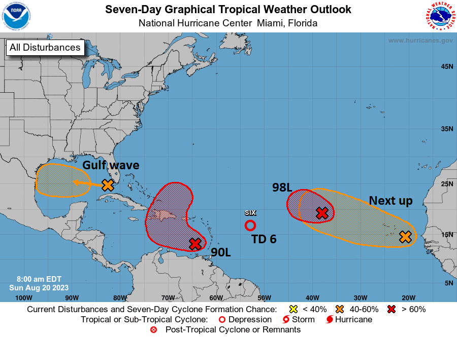
A tropical wave in the Gulf offers a slight development chance and some beneficial rains for south Texas, and of the three tropical storms in the Atlantic this morning, only Franklin needs watching for land impacts in Hispaniola.

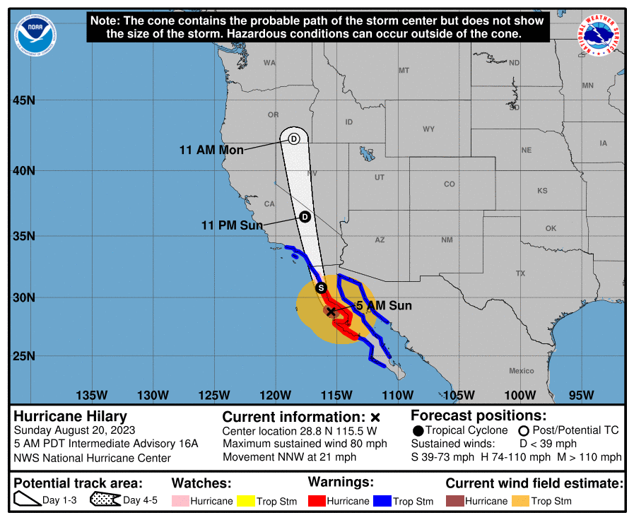
Tying a bow around Hilary

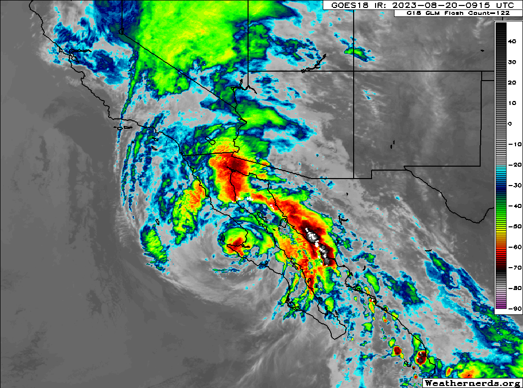
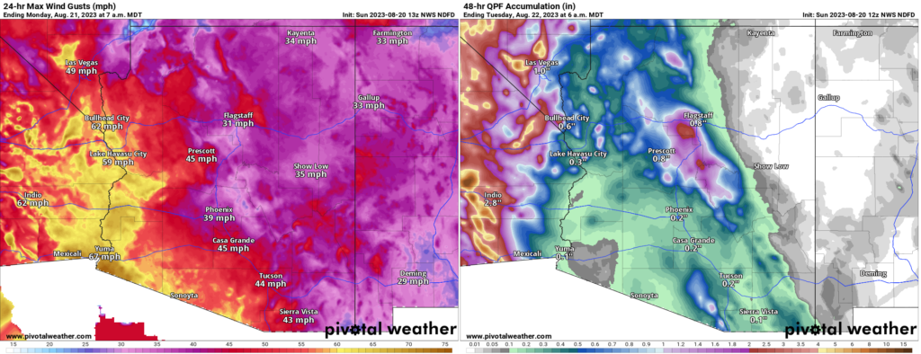
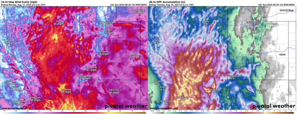
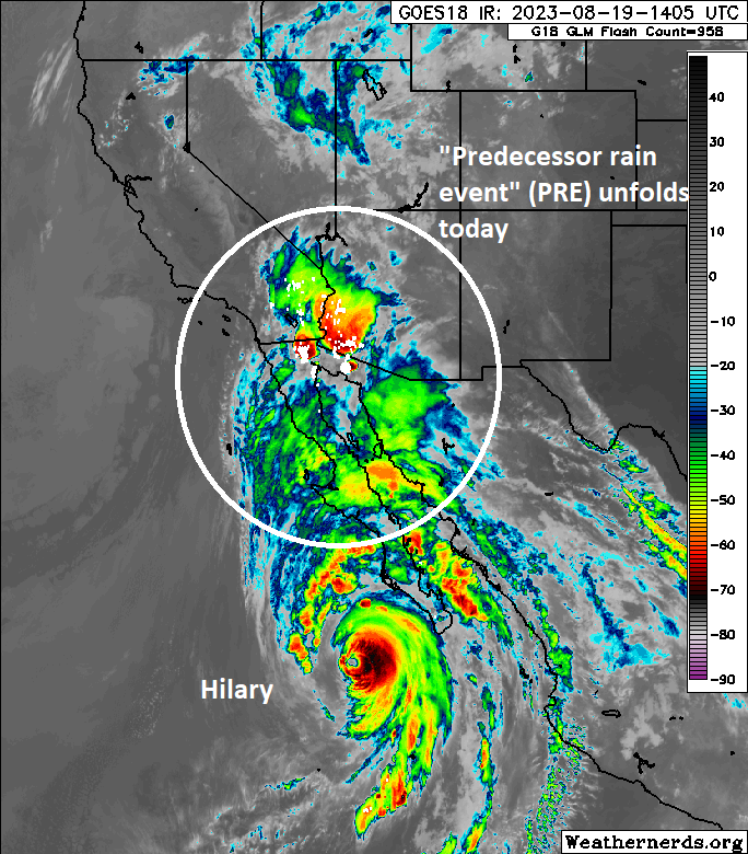
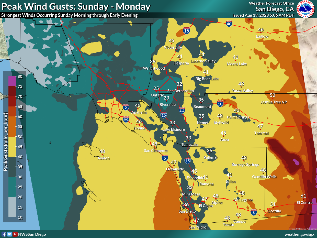
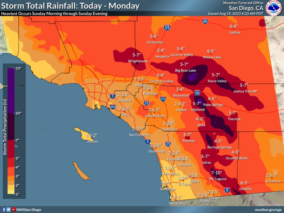
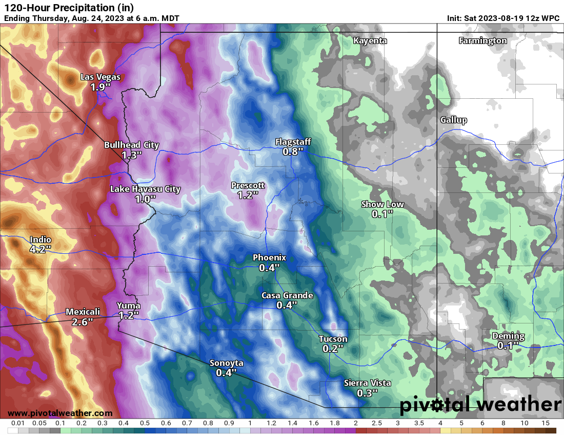
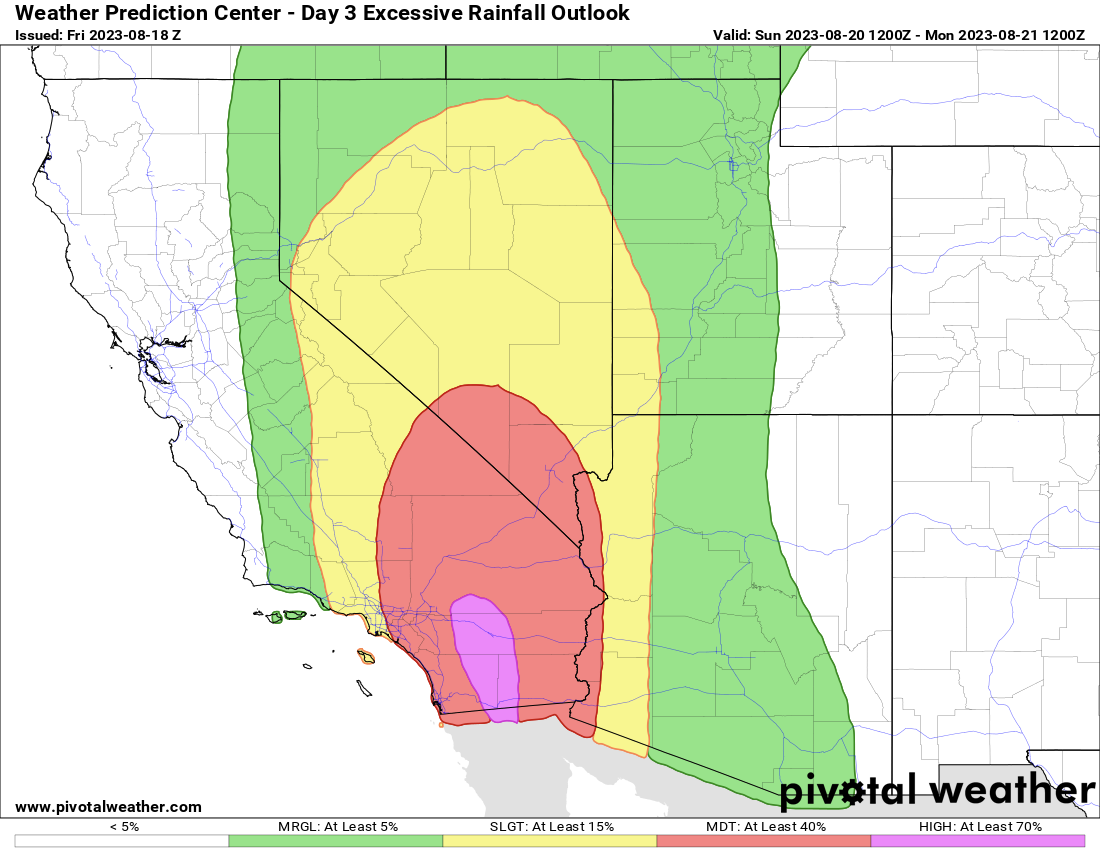
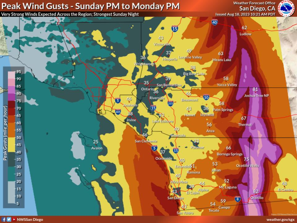
We hope that all our new readers in California and the Southwest are doing ok this morning after Hilary’s rains yesterday. It sounds as if the mountains and some parts of the desert were particularly hard hit overnight with numerous debris flows, mudslides, and road washouts reported. A better assessment of the damage should emerge today.

While we are a tropics-focused site, we hope you’ll find our information interesting to share with your friends and family. And we may cover more than just hurricanes here eventually, in which case California would be a focus of ours. We are happy to have you here.

Gulf system & Texas rain

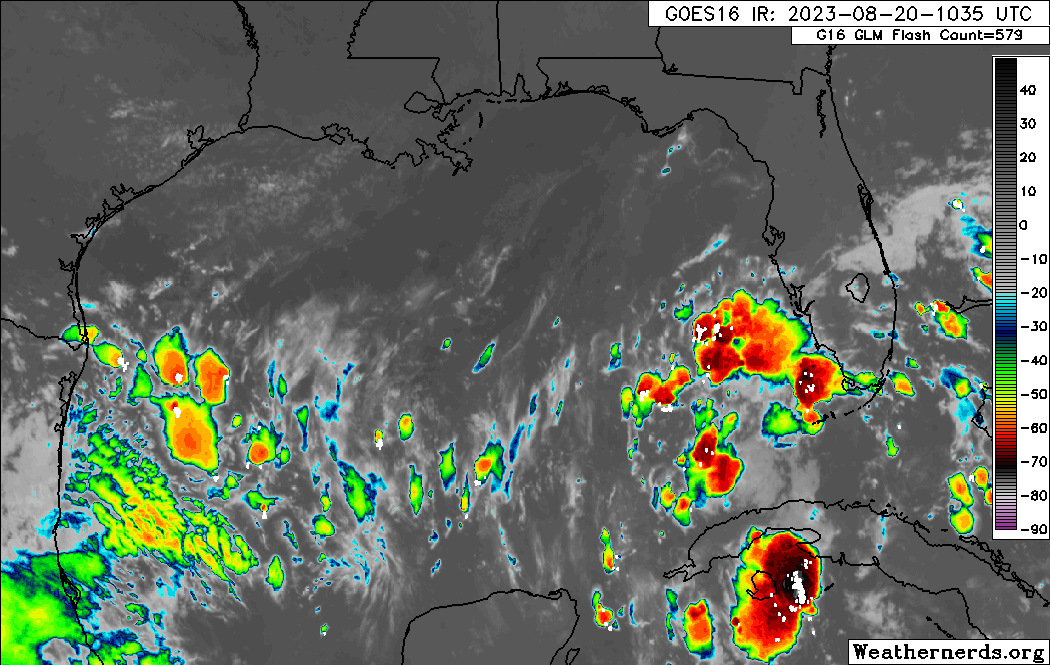
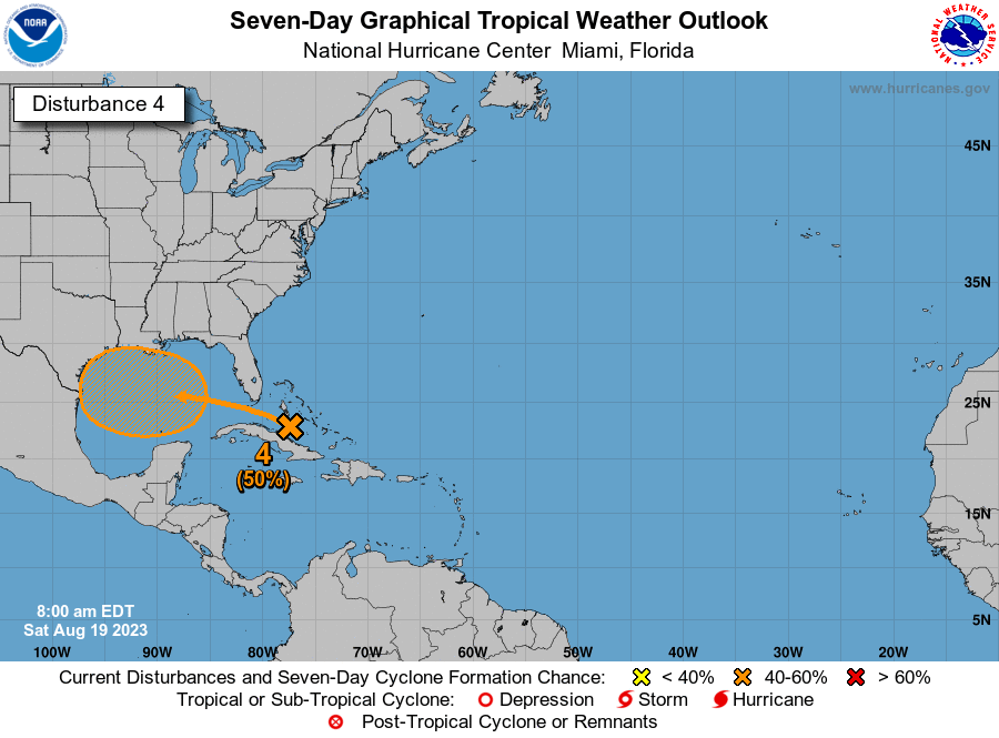
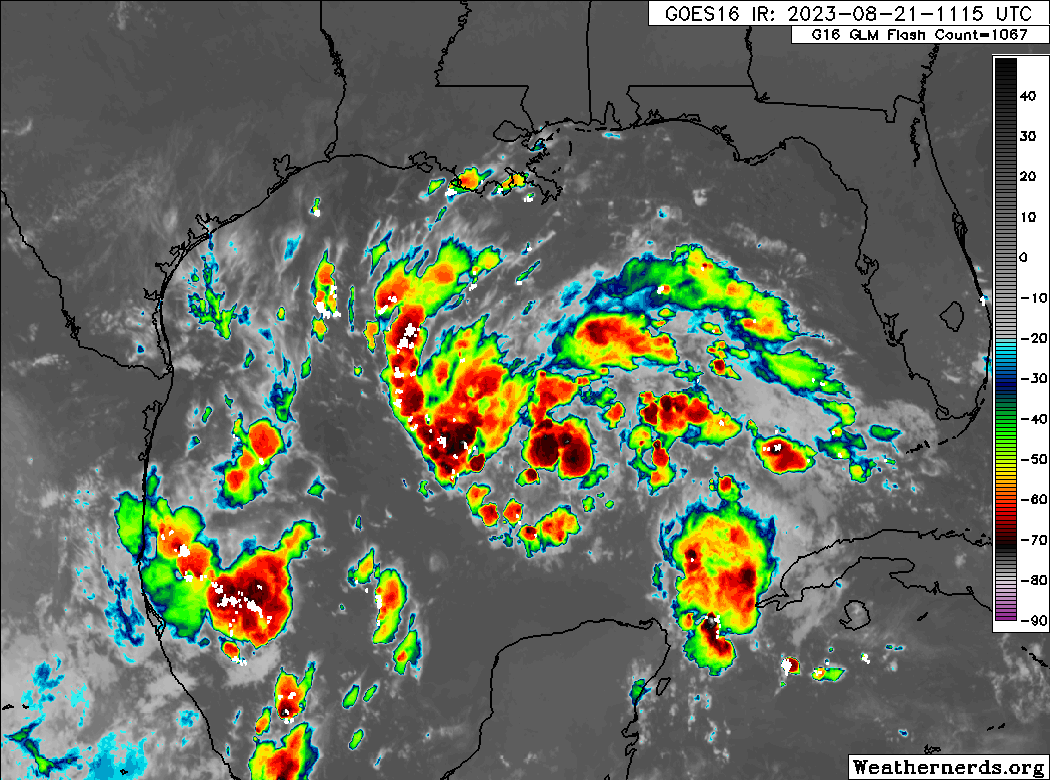
First up today, let’s talk about the Gulf of Mexico. We have seen no real progress toward better organization overnight from the tropical wave, Invest 91L in the eastern Gulf.

Invest 91L is not much better organized this morning, which may be a good thing given its size and the look it has on satellite. It still has a better chance than not of becoming a depression or tropical storm before reaching Texas Tuesday morning. (Weathernerds.org)

Just as a quick reminder: Invests are really just meteorological classifications given to tropical disturbances so extra data can be compiled about them; literally “an area of investigation.” There’s no strict definition, but they go from 90 to 99 and then recycle again. In the Atlantic we use “L” as an identifying abbreviation. The East Pacific is “E,” West Pacific “W,” etc.

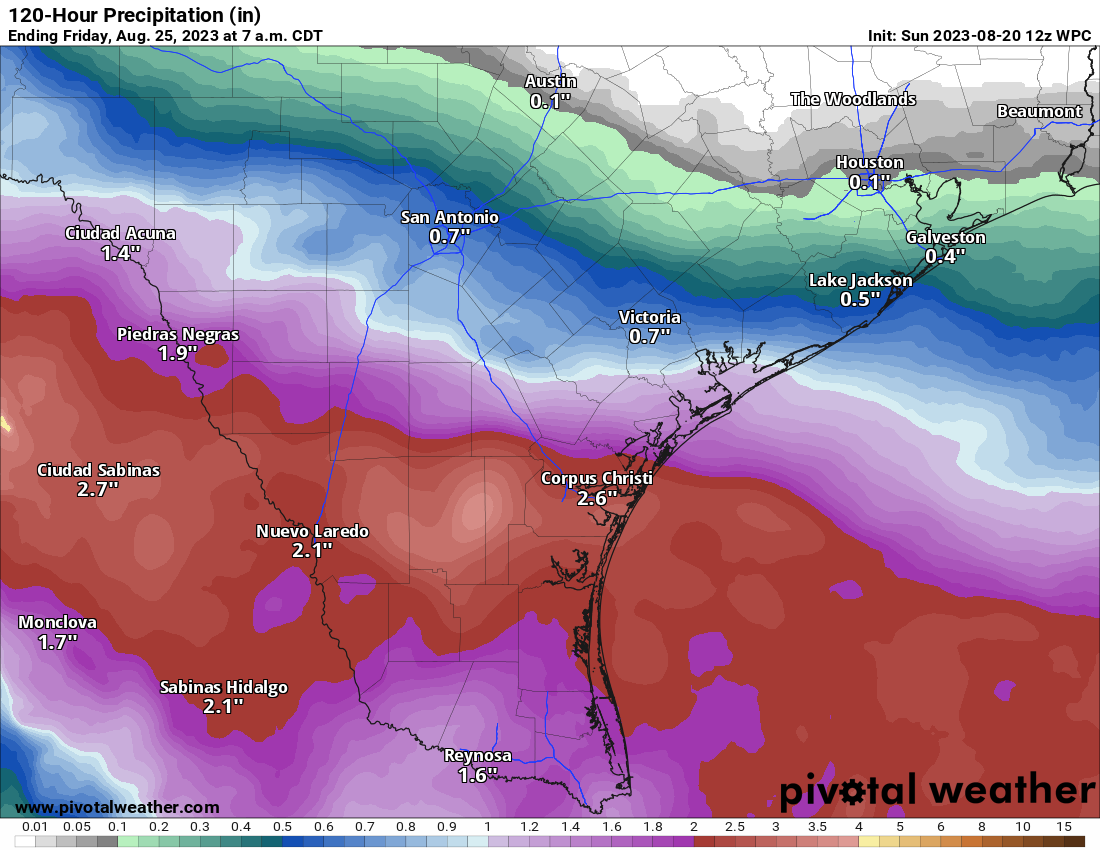
Anyway, 91L has a broad circulation this morning but does not appear to be tightening up any as of yet. The good news is that this system has about 24 hours left over water before it comes ashore in South Texas. The most likely outcome at this point is an approach just south of Corpus Christi or north of Brownsville.

The most likely track of 91L brings it between Corpus Christi and Brownsville in South Texas, though it’s not out of the realm of possibility that it comes in south of the Rio Grande Valley in Mexico. (Tomer Burg)

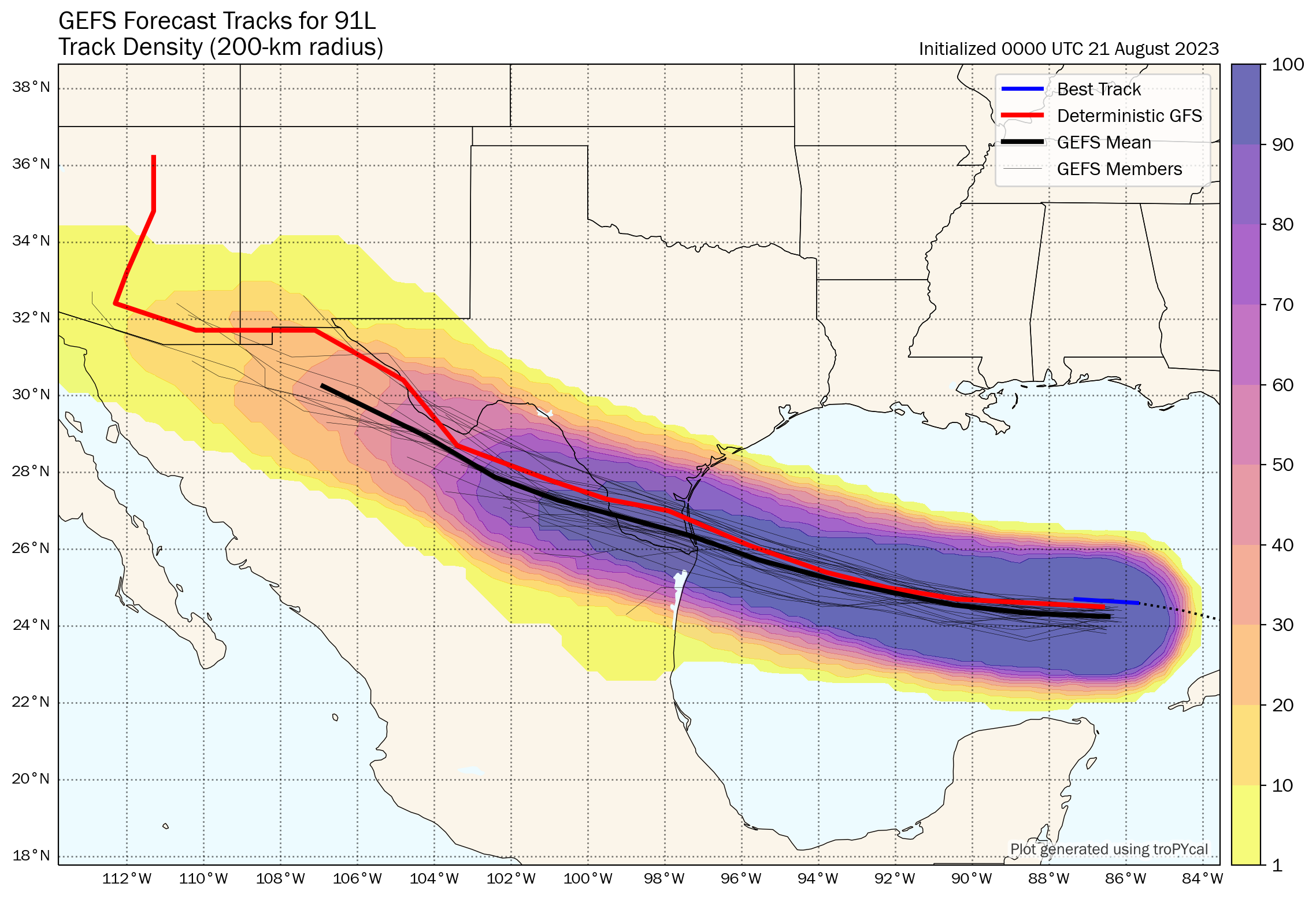
Given that we have 24 hours left and given how this thing looks on satellite, my hunch is that if we see this upgraded we may skip the formalities and go right to a tropical storm. The next name on the list would be Harold. At worst, this would probably become a low-end tropical storm (45 to 55 mph maximum sustained winds, mostly in heavier rain bands and over water).

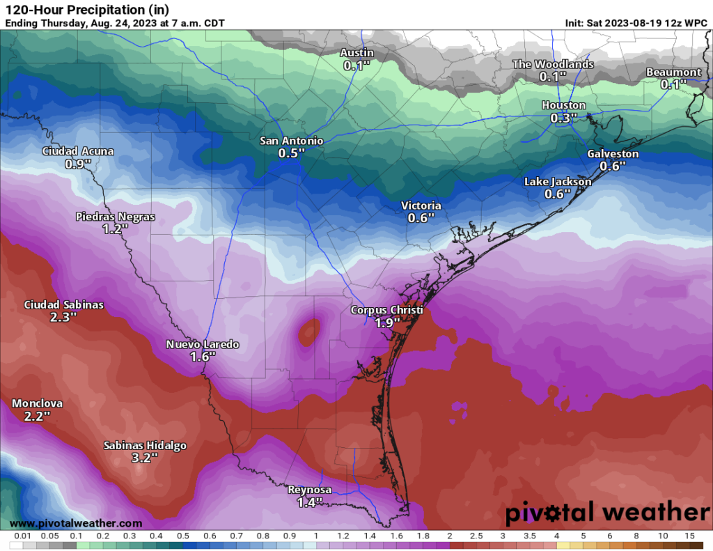
More importantly, this will be a rainmaker for Texas. The entire state desperately needs rain.

Drought is getting extreme to exceptional in much of Texas. Rainfall from a steadily moving tropical system would be mostly welcome at this point. (US Drought Monitor)

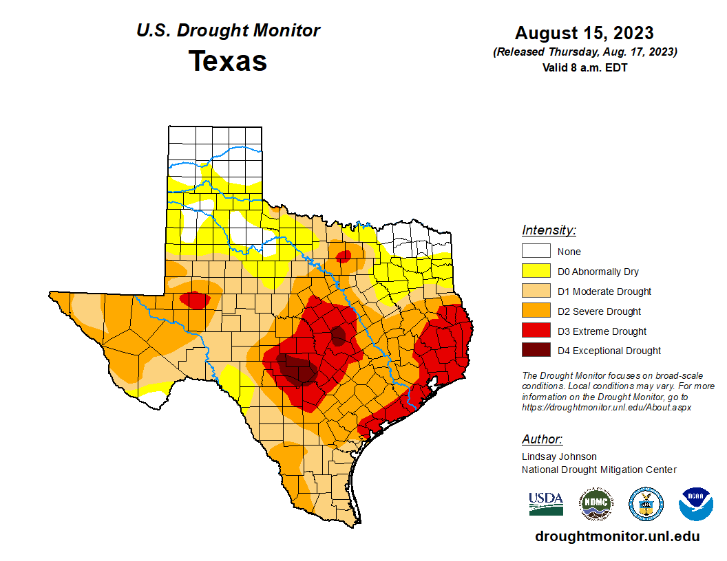
East Texas and the upper Texas coast are in extreme drought, with pockets of exceptional drought in Hill Country northwest of San Antonio. A quick moving tropical system would be virtually 100 percent positive in Texas right now. This will help. Rain totals of 1 to 3 inches with higher amounts are expected for South Texas, mainly south of Corpus Christi into the Rio Grande Valley and west toward Laredo. Northern Mexico will also receive healthy rains from this.

Rainfall of 1 to 3 inches on average will be expected in South Texas, with pockets of higher amounts in parts of Brush Country and in the mountains of northern Mexico. (Pivotal Weather)

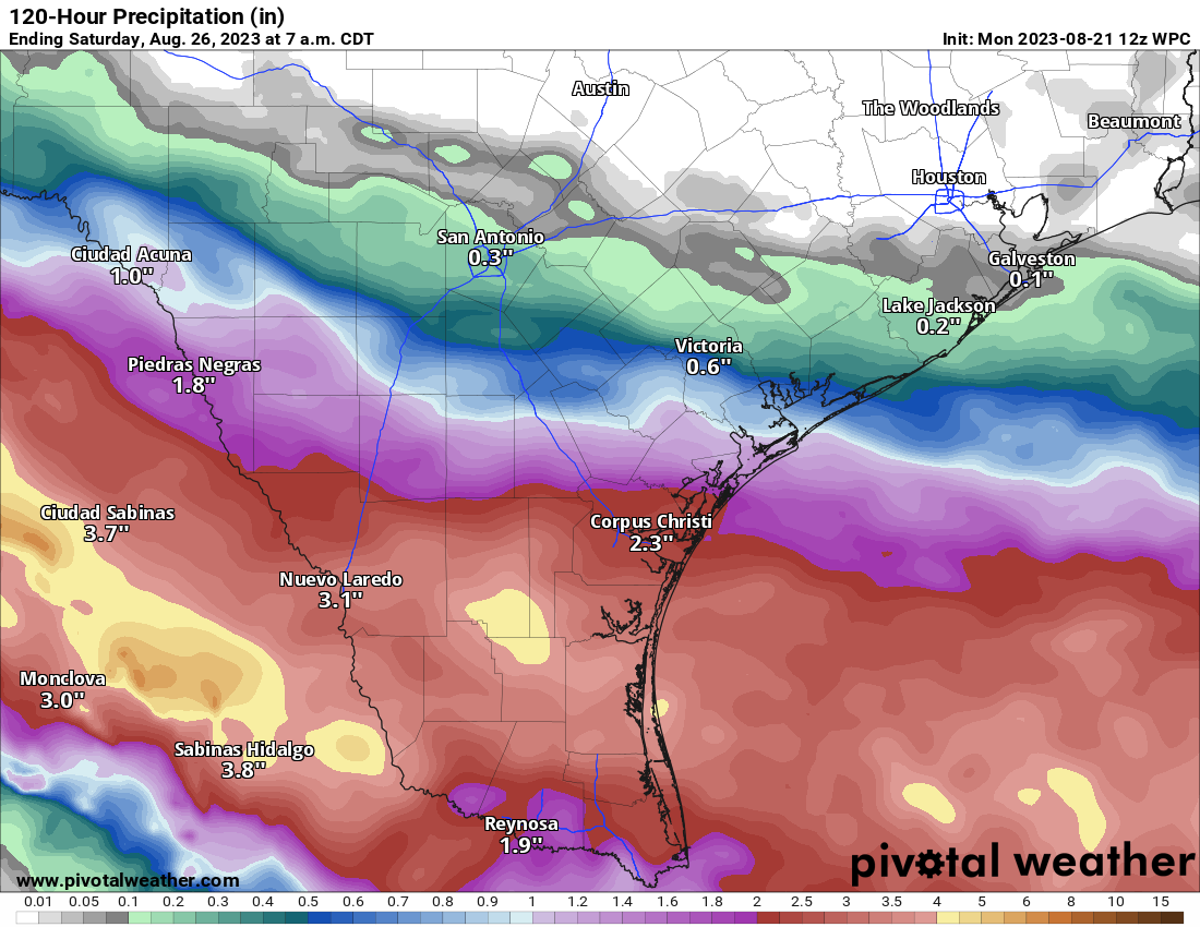
While this will not end drought for South Texas, it will greatly help. Unfortunately, the hardest hit parts of the state are expecting little to no rain this week, meaning drought and fire danger will worsen. See our companion site, Space City Weather for more on that.

Franklin to turn toward Hispaniola

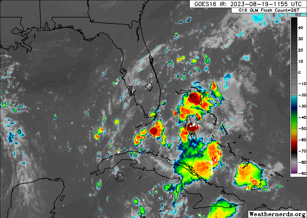
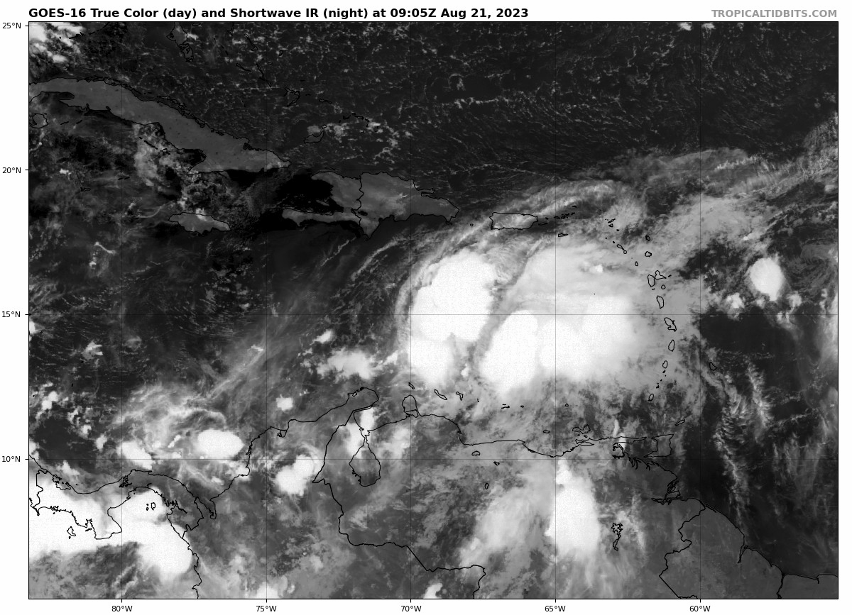
Yesterday afternoon, Invest 90L in the Gulf was upgraded to Tropical Storm Franklin. Franklin is impressive looking this morning, less so for organization and more for how much moisture it is carrying.

Tropical Storm Franklin should make a hard right tonight toward Hispaniola, bringing very heavy rain to the Dominican Republic. (NOAA NHC)

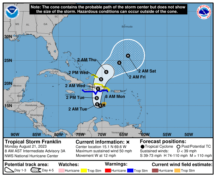
Franklin is expected to turn to the north, almost like something you’d see in autumn. Why? An upper level low and a fairly deep trough for August over the western Atlantic will act to scoop it up, as high pressure over the southern Plains effectively acts as a “block” to letting this come west.

The sun rises on a moisture-laden Tropical Storm Franklin in the Caribbean (Tropical Tidbits)

So Franklin will make a hard right toward Hispaniola tonight or tomorrow. Exactly where this turn happens will determine where on Hispaniola Franklin comes ashore. This will have implications on specific rain totals for both Haiti and the Dominican Republic. As of now, the heaviest rains from Franklin are poised to hit on the Dominican Republic side of Hispaniola, where upwards of 8 to 12 inches or more will be possible, especially in the eastern part of the country.

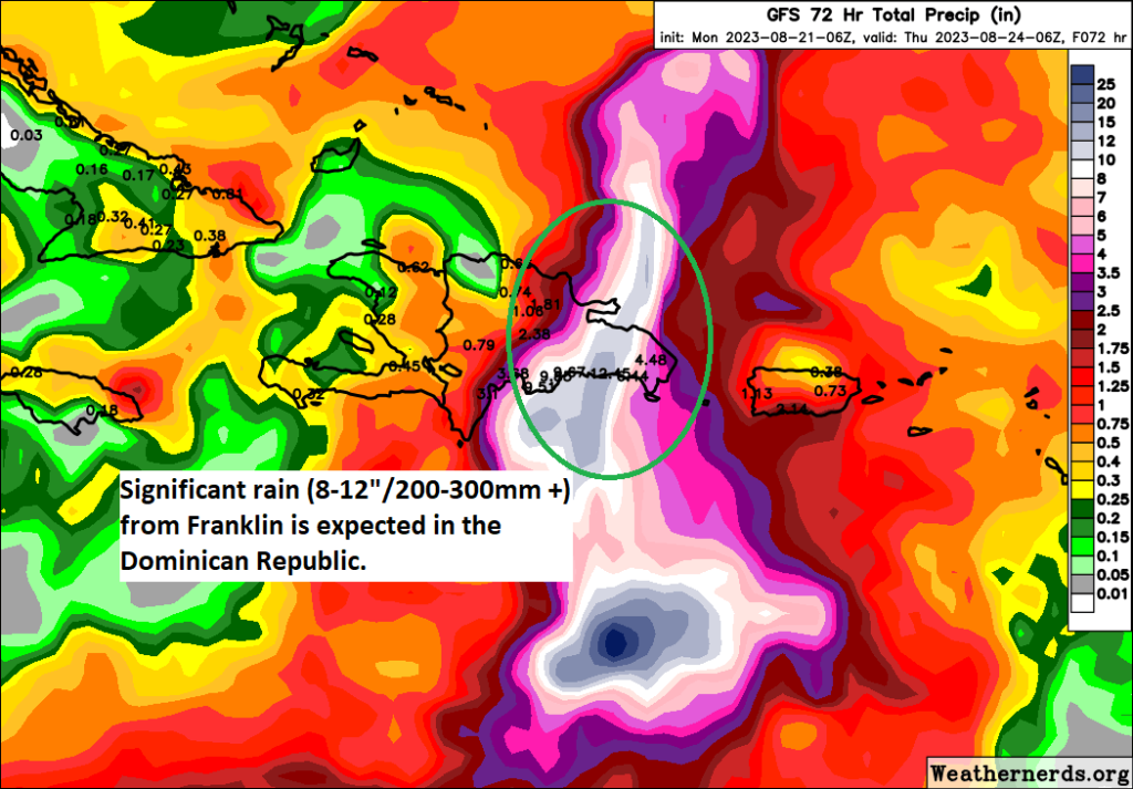
Flooding is possible there, and some of it could be relatively significant, in addition to tropical storm conditions. For Puerto Rico, you’ll be on the eastern flank of Franklin’s circulation, which should allow for occasional bands of rain to push north into the island, and this too could lead to some more localized heavy rain or flash flooding issues with totals of 3 to 6 inches possible in the worst cases.

Franklin will likely hit Hispaniola as a moderate to strong tropical storm. The island will weaken it somewhat as it emerges to the north, but then it may find a more hospitable environment out ahead of it to gain strength. There is a good chance we could have Hurricane Franklin by the end of the week over the open Atlantic. Initially, Franklin will turn north or northeast. Except there’s a bit of a problem. Models indicate a ridge in the eastern Atlantic may try to build west enough to bump Franklin back off to the northwest, which means there is at least some chance Bermuda will be in play for this as it goes north. Eventually Franklin will turn back out to sea, but where that happens relative to Bermuda is impossible to say right now. So interests in Bermuda will want to follow Franklin’s progress closely in the coming days.

Additionally, if Franklin can get its act together in the Atlantic, there may be some rough surf and rip tide conditions possible on the U.S. East Coast next weekend.

The rest of the Atlantic

Tropical Depression 6? Now Tropical Storm Gert and soon to be history. Tropical Storm Emily formed yesterday from Invest 98L, and that should dissipate today. It is no threat to land. Behind Emily, we have Invest 92L, which has a solid chance at becoming a named storm in the next few days.

Invest 92L will gradually get its act together and has a good chance of developing while on its way out to sea in the open Atlantic. (Weathernerds.org)

It will likely also turn out to sea.

What’s next?

Looking out in time, once we unclog the Atlantic of the current logjam of systems, we can focus our attention more on two areas. One will be the potential that a system can spin off a potential “gyre” circulation over Central America, but that is looking a bit less impressive today than it did last week. The other area will be off Africa, where additional waves may emerge and threaten development in the next couple weeks. In truth, nothing looks especially concerning right now as we head into the start of September. Obviously, we’ll keep you posted.

Hilary’s rains and winds arrive in the Southwest today as the Atlantic churns out a lot of noise

For those of you just interested in the Atlantic & Gulf activity, scroll down. We will begin again today with Hurricane Hilary. For folks in California, charge your phones, as power outage risks will increase today with Hilary coming north.

Some people will be apt to call this a “bust” already. As those of us in Houston know all too well, when round one of rain ended and the sun even came out for a time, a lot of people were caught off-guard by Harvey’s main event that night. Hope for the best, but the forecast data has not markedly changed and severe impacts remain a likely outcome, especially in the desert.

One-sentence summary

Hurricane Hilary is expected to impact the Desert Southwest today with extremely heavy rain and a high risk of significant flooding, while South Texas eyes beneficial rains from a tropical wave this week, one of several Atlantic disturbances right now.

Hurricane Hilary: Still likely to bring severe rain & flooding to the desert

The majority of the forecast is on track, with a few noteworthy changes today, mainly in the form of higher wind forecasts in southeast California, Nevada, and southwest Arizona. Hilary is approaching the coast of Baja this morning with its 85 mph winds, mostly as expected.

Hilary should make landfall somewhere in northern Baja later this morning or this afternoon. Moisture extends well out ahead of it, and tropical moisture will arrive in the Southwest today. (Weathernerds.org)

Very little has broadly changed in terms of the track, but a few nuances lead to a little more wind for the Southwest U.S. Hilary should come north as a tropical storm into California, transitioning to a depression near Death Valley, and then getting absorbed into the U.S. weather pattern over Nevada.

Hilary will maintain tropical characteristics deep into the Southwest U.S., before becoming “post-tropical” over the Great Basin. (National Hurricane Center)

Let’s walk through impacts again today.

Coastal SoCal Metros (Santa Barbara-Ventura-LA-OC-San Diego)

For most in these areas, Hilary will be a considerable inconvenience. However, there will be issues with flooding in spots. There will also be concerns about mudslides and debris flows in the foothills and near burn scars. While the majority of valley and coastal locations will see 1 to 3 inches of rain, that will be enough to cause flash flooding of roads, and travel later today may become a little difficult. Urban flooding is always a concern when you get rain rates of an inch an hour possible, which may be what occurs in spots.

Wind gusts will peak in coastal SoCal later this morning and this afternoon into evening as Hilary comes north. Power outages are likely in spots. (NWS San Diego)

Flood watches are posted, and honestly if you don’t need to be out later today, it’s best to stay put.

While winds may not look dramatic on the map above (with 30 to 40 mph wind gusts on the coast), there will be stronger winds in spots and likely some power outages.

Conditions from Santa Barbara through San Diego will improve tomorrow.

Rainfall will range from 1-3″ between Ventura County and San Diego. Higher totals are likely in the mountains and deserts and in localized spots.

Inland SoCal Metro Valleys and Mountains

The impacts inland from the coast will vary. North and east-facing mountain slopes will likely see the heaviest rainfall with 3 to 10 inches likely and higher amounts not out of the question. Rate rates will be intense, and in those particular mountains, we may see mudslides, rock slides, and the potential for significant, rapid-onset flooding. This will include the mountains east of San Diego, the north side of the San Gabriels, San Bernardinos, and Ventura County mountains. The Antelope Valley north of LA may be very susceptible to flooding due to rain in the mountains upstream.

A “high” risk of excessive rainfall and flooding is in place today for the eastern half of San Diego County into Palm Springs, the Antelope Valley, Morongo Basin (including Joshua Tree), much of the Mojave Desert, Death Valley, into Nye County, NV/the Amargosa Desert. (Pivotal Weather)

Flash flooding or debris flows will be likely in some of the foothills and mountains, and travel, particularly into the mountains or across the Antelope Valley will be discouraged later today.

Winds will mimic patterns that we usually see in these regions during Santa Ana wind events, with gusts locally up to 50, 60, or 70 mph possible. This isn’t a Santa Ana, but because the wind direction of an approaching tropical storm is similar to how winds setup in Santa Anas, you’ll get that pattern. Prepare for power outages in some of these areas.

California Deserts

As noted above, the Antelope Valley will be particularly susceptible to heavy rainfall, but the Mojave Desert as a whole will be as well. That high risk from the NWS Weather Prediction Center remains in effect today, as it has since a few days ago. Confidence is high in major, damaging flooding impacts in these areas, which may see the equivalent of a year or more worth of rain today. Areas from the Imperial Valley and Salton Sea north to Death Valley are at highest risk for poor outcomes today. Locally, mountain peaks will enhance rainfall some, including the Panamints near Death Valley. Travel is discouraged today in the deserts and between the coast and interior.

Winds will also be an issue here, with 40 to 60 mph gusts widespread and risk for higher in spots. Prepare for power outages in these areas.

Tropical storm and high wind warnings are in effect for most of Southern California, including the deserts, with gusts of 40 to 60 mph and higher likely in some of the interior areas. (Pivotal Weather)

Arizona

Conditions tend to lessen some in Arizona, but there will still be issues with flooding and strong winds in the western part of the state.

Strong winds are likely in southwest Arizona, and power outages are a possibility in these spots. Rain totals (right) don’t look impressive, but there will be pockets of heavier rain and flash flooding possible, perhaps in some of the mountains north of Phoenix or in and around the Colorado River above Lake Havasu City. (Pivotal Weather)

Rain totals were dropped a good bit near Yuma today, as it appears a “dry slot,” or an area of dry air in between rainy bands may set up near Yuma.

Nevada

For Las Vegas, the threat of flash flooding is real, even if the highest risks are to the west of there. Urbanized desert is especially susceptible to flooding, so if a cell or band of heavy rain just happens to set up over the Las Vegas Valley, you will have a recipe for significant urban flooding. Be aware and prepared today in Vegas.

Heavy rains will be likely in Nye County in particular from Hilary. Significant flash flooding is possible there. Strong winds will extend well north into the Great Basin as well. (Pivotal Weather)

The heaviest rain may occur near Mount Charleston. As the NWS in Las Vegas noted this morning, the Nevada 24 hour state rainfall record previously occurred there. The 7.78 inch total on Mt. Charleston may get challenged today.

In addition to the rain, strong winds will be an issue here as well and power outages are possible in southern Nevada.

Conditions should improve from south to north tomorrow.

Lots of Atlantic nuisance and noise

Shifting into the Atlantic basin now. The NHC’s outlook map looks more like a leaked flag football playbook or something.

There are a lot of items on the outlook map today, but none of them look particularly serious in terms of impacts. (NOAA NHC)

Right out of the gate, let me just say that none of these systems look particularly menacing or troublesome for any areas. Busy as it may be, we’ll call this a nuisance setup. Let’s walk through these things.

Gulf wave: A rainmaker in South Texas

The tropical wave we’ve been talking about for several days is finally in the Gulf of Mexico this morning, and based on satellite imagery, it is not terrible looking. Organized, no, but vigorous, yes.

A tropical wave in the Gulf with a 50% chance of developing over the next couple days is robust looking but disorganized for now. (Weathernerds.org)

This will continue due west across the Gulf and make it into Texas by Tuesday morning. This has a 50/50 shot of becoming a depression or low-end tropical storm as it approaches Texas, but it is unlikely to surpass that level. The main impact from this system will be rainfall in Texas, a needed commodity. Sadly, for Houston and drought-stricken east Texas, this will do next to nothing. However, South Texas needs the rain too, and they will get some as this system moves in.

1 to 3 inches of beneficial rain is expected for South Texas, including Corpus Christi into Laredo and across northern Mexico. (Pivotal Weather)

Look for about 1 to 3 inches of rain for areas south of Matagorda Bay and lesser amounts north of there, to near 0 rain for the I-10 corridor in Houston and SE Texas.

Invest 90L: May develop today, rain for Hispaniola, Bermuda in the future?

The next wave to discuss is Invest 90L, which is located in the southeast Caribbean. It is beginning to attempt to develop there, and there’s some chance this becomes a depression or even Tropical Storm Emily today.

A robust tropical wave in the southeast Caribbean has a good chance at becoming a depression or storm in the next 24 hours. (Tropical Tidbits)

If you look at the NHC map above, you can see how 90L’s potential development takes on an “L” shape. The good news is that 90L should be drawn up north and out to sea rather quickly. The bad news is that it could impact Hispaniola, particularly with heavy rainfall. Bermuda may also want to keep an eye on 90L’s progress over the coming days. We will watch this closely for those areas this week.

Tropical Depression 6: Heads for the exits today

Invest 99L turned into TD 6 yesterday, and it will degenerate back into a wave today. Thanks for joining us.

Invest 98L & Africa waves

We expect development of Invest 98L in the next day or so, at least to a depression, maybe a tropical storm. But it will stay out at sea. Subsequent waves off Africa will likely behave similarly in the coming days.

Hilary heads north, aiming to drench the California deserts, while low-end Gulf development odds inch up a little

One-sentence summary

The forecast for Hilary is basically unchanged with a severe to historic rainstorm coming for the California deserts and parts of Nevada, while the odds of lower-end Gulf of Mexico development have nudged up a little and some welcome rain heads for South Texas.

Hurricane Hilary: Major flooding potential still likely in the California deserts

We’ll start with Hilary today. Hilary is beginning to feel the influence of cooler water and begin the transition from major hurricane to moderate hurricane and major rainstorm.

Hilary will graze central Baja as a hurricane tonight, then meander north as a tropical storm and major rainstorm in northern Baja, southern California, and Nevada. (NOAA National Hurricane Center)

Hilary’s forecast track remains basically in line with the forecast since yesterday, coming north into SoCal as a tropical storm, a status which it may maintain all the way into Nevada. There are currently tropical storm warnings across most of Southern California, a first for them in modern history. Rain will actually start today as Hilary interacts with an abnormally strong trough off the California coast. This is an event we call a PRE, or predecessor rain event. I don’t want to oversaturate you with science, but you can read about what they are here. Suffice to say, this is not a common feature in California, Arizona, and Nevada.

Hilary is sitting off the southern tip of Baja this morning, racing north, while rain breaks out ahead of the storm. (Weathernerds.org)

These types of rains can just help juice things up for the main event (tomorrow) from Hilary itself. Let’s talk things out by region to give you a sense of the impacts.

LA, Orange County, and San Diego

From what I’ve seen on social media, some people in Los Angeles think a hurricane is coming for them. While there will be impacts from Hilary in LA, the OC, and San Diego, the impacts will be worse inland in the deserts. Still, preparations for the summer equivalent of a big winter storm should probably be made, particularly along the immediate coast.

Forecast peak wind gusts for the California desert, Orange County, and San Diego areas will be 35 to 45 mph or a bit stronger on the coast from LA south to San Diego. (NWS San Diego)

Wind gusts won’t be incredible, but they will probably push on tropical storm intensity along the coast and in the Channel Islands. Terrain in these areas means that wind will vary. With the storm going east of the mountains, winds will basically mimic a Santa Ana wind event, at least in terms of direction. So basically, areas that see the strongest winds in Santa Ana events in LA and San Diego will probably see the strongest winds with Hilary.

Rain totals in LA and San Diego will be 1 to 3 inches, enough to certainly cause some flooding, but the most serious impacts would be very limited in these areas I think to the immediate coastline and any burn scar areas, where heavy rain could lead to debris flows or mudslides. For the vast majority of metro SoCal, this will be a curiosity and inconvenient event, not a catastrophic one.

This also includes places like Riverside and San Bernardino, metro Inland Empire cities that are generally west of the north-south mountains.

Mojave Desert, Palm Springs, Imperial Valley, Death Valley

This is the area that those of us that are meteorologists are most concerned with in terms of extreme to catastrophic flooding impacts.

Rain totals of 4 to 7 inches are likely in the desert regions of Southern California, with extremely dangerous and damaging flooding possible in places like Death Valley, Joshua Tree, and the Imperial Valley. (NWS San Diego)

This is basically San Diego County east of the mountains, Imperial County, eastern Riverside and San Bernardino Counties, and Inyo County in California. Rain totals will equal 1 to 2 years of rainfall over 1 to 2 days for some of these areas. For those of you scoffing at 5 inches of rain leading to catastrophic flooding, remember that the deserts and areas with terrain are nowhere near as equipped as many places in the East to handle this type of rain and these type of rain rates. Land composition is much different in the West than the Central and East, and that means thresholds for severe outcomes are different.

Anyway, this is the region we are most concerned with. Travel between the coastal metros and places like Death Valley, Vegas, Kingman, Phoenix, and Yuma will almost certainly be disrupted for a time due to flooding and/or infrastructure damage. Damage in some parts of Joshua Tree National Park and Death Valley could be severe and extensive. As someone who has spent time in both parks, this saddens me a bit. Hopefully it’s not as bad as it could be, but these forecast totals are definitely troublesome. Please heed the warnings of your local National Weather Service offices (most likely San Diego, Phoenix, or Las Vegas) as this event unfolds.

Las Vegas and southern Nevada and Utah

Depending on exactly how the storm unfolds, impacts across Nevada may range from modest to severe. A high risk for flooding on Sunday is posted into Death Valley, but it does not include Las Vegas or southern Nevada at this time.

A moderate risk (level 3/4) of excessive rain is posted in Nevada on Sunday. (NOAA)

A moderate risk (level 3 of 4) is posted for most of Nevada tomorrow for excessive rainfall. We expect some degree of flooding here, particular in isolated spots and in favored mountain locations. Total rainfall in Las Vegas is expected to be on the order of 1 to 3 inches, an amount that will surely cause some flooding issues, but hopefully not the severe issues we’ll see in the California deserts.

Rainfall of 1 to 3 inches is expected in the Las Vegas metro, with higher amounts in the mountains. A widespread 1 to 4 inches is expected across the southern half of Nevada. Impacts will be less significant in northern Nevada. (Pivotal Weather)

Even up into southwest Utah, rain totals of an inch or two are possible for places like St. George and even not far from Zion National Park. Flood watches are posted for all of Nevada except Reno/Tahoe and north. Much of Utah is also under a flood watch.

Flood watches extend north of Nevada into southwest Idaho and southeast Oregon as well, where remnant rain will produce localized flooding.

Arizona

Heavy rain and pockets of flash flooding are likely in western Arizona as well from Hilary.

Rain totals of 1 to 3 inches are likely along the Colorado River downstream from Lake Mead in Arizona. Flood watches are posted west of Phoenix and Flagstaff. (Pivotal Weather)

Flood watches are posted for all of western Arizona, including Prescott, Yuma, and Kingman. Rain totals of 1 to 3 inches are likely here with lesser amounts in eastern Arizona. Flooding is not currently expected to be an issue in Phoenix.

The bottom line: Hilary will bring varying impacts across the southwest, but the most concerning ones will occur in the deserts of California where we are very concerned about flooding. Please be ready for a rough Sunday and/or Monday in those areas.

Gulf of Mexico development chances inching up

The National Hurricane Center has upgraded the potential for the Gulf system to attain tropical depression or tropical storm status early next week to 50 percent.

There is a 50 percent chance that the tropical wave entering the Gulf of Mexico can become a depression or tropical storm before coming ashore in South Texas next week. (NOAA NHC)

Looking on satellite this morning, the disturbance aiming to come into the Gulf is showing some spicy thunderstorm activity, but it lacks any real organization still at this point.

There are definitely thunderstorms erupting around a disturbance moving into the Florida Straits today, but there remains little to no organization from this system. (Weathernerds.org)

This currently is just a few blobs of heavier thunderstorms moving into the Gulf. As this comes west, it will probably encounter a little bit of a less hostile environment and may begin to slowly organize. But it’s going to be hauling west and will have less than 48 hours over the Gulf meaning even if does organize, it will likely come ashore in South Texas as depression or low-end tropical storm, at worst.

The main impact from this, besides some modest marine impacts, will be rainfall, much needed rainfall at that. However not all of Texas gets to play.

Rain over the next 5 days is expected to be highest from Corpus Christi to Brownsville and inland into Mexico. (Pivotal Weather)

In fact, much of the Houston area may see little to no rain from this system. Perhaps a bit south of I-10 or near the coast. Corpus Christi? Brownsville? Laredo? Perhaps 1 to 3 inches of extremely beneficial rain. That will extend into Mexico, which also could use some rainfall. But drought conditions that have taken hold in much of East Texas are going to remain or worsen. As we head into early September, the persistent ridge that has been bringing day after day after day of high heat to Texas may begin to weaken some, but it does not want to let go just yet. Sadly, there is no well-defined “next best” chance of rain for drought-plagued parts of Texas after this.

Elsewhere: Multiple Atlantic waves

A quick look at the NHC fruit basket shows three Atlantic disturbances, from left to right Invests 90L, 99L, and 98L.

Invest 98L has the best odds of developing over the next few days out over the open Atlantic, while newly minted Invest 90L has about a 40 percent chance of doing so in the Caribbean. (NOAA NHC)

Of the three, Invest 98L still has the best chance of forming into something, though it will remain out over the open Atlantic. Invest 99L is a nothingburger. Invest 90L may draw in most people’s eyeballs. We’ll keep an eye on this one, but at this point development looks sluggish and lower-end. Just wanted to make sure you knew we weren’t ignoring the rest of the Atlantic!

Hilary continues to look like an extremely serious flood threat for California, Nevada, and parts of Arizona

One-sentence summary

Morning forecast models continue to underscore the seriousness of the flooding threat facing the Southwest via Hurricane Hilary’s abundant rainfall.

Happening now: Hilary holds as a major category 4 storm

Hurricane Hilary remains a powerful Category 4 storm. It has about 12 to 18 hours left before ocean conditions begin to cool, which should allow for Hilary to weaken somewhat as it comes north.

Hilary is close to a textbook looking storm as it turns northwest off the coast of Mexico. (Tropical Tidbits)

Hilary’s forecast track has not changed too terribly much so far today. In fact, one could argue that aside from a little nuance, Hilary’s future track is now mostly locked in and likely has little deviation expected.

Despite a little nuance, Hilary’s track is mostly locked in for the next 48 hours, with a path just off Baja, comfortably west of Cabo, and hurricane conditions possible in central or norther Baja as Hilary treks close by. Hilary is likely to make landfall near San Diego as a tropical storm on Sunday night or Monday morning. (Tropical Tidbits)

The message for folks in northern Baja, southern California, Nevada, and far western Arizona is pretty clear: While there may be a few details-oriented changes between now and Monday, the overall impacts you should expect will likely change very little. In other words, what you see (now) is what you (should) get.

The rain risk in the Southwest: It is very serious

I don’t want to bury the lede here. While there will be tropical impacts, including and especially to parts of Baja, the main and most severe impacts from Hilary will likely be in the form of flooding and extreme rainfall in the Desert Southwest. We don’t take these situations lightly, and if you’re new to our coverage, you might ask why we’re writing so aggressively about this. In the current media landscape, they’re valid questions, but in this case the answer is that this actually is that serious.

Click to enlarge the rainfall forecast through next week for California, Nevada, and parts of Arizona. (Pivotal Weather)

The current rainfall forecast for Indio, CA is about 4.7 inches. In a typical year, Indio expects just under 3 inches of rain. So, this is a place that already struggles to handle rain and has a chance to see more than its annual average rainfall over 2 days. This is exactly why the Weather Prediction Center issued their first high risk in this region for excessive rain on Sunday. As a Houston-based forecaster who has worked closely with the WPC and their rainfall products, I can assure you that issuing a day 3 high risk is not a decision they take lightly.

The day 3 high risk for excessive rainfall is a rarity to begin with, let alone in the California desert. (Pivotal Weather)

They issue high risks only when they are very confident that what they think will happen will happen. High risk rainfall days are associated with most of the flood damage that occurs in the United States.

Over 80 percent of all flood-related damage in the U.S. occurs on high risk forecast days. (NOAA WPC)

So I just want to be clear with folks that this is a big deal. If you live in the Coachella Valley or Palm Springs in particular, as well as “downstream” from any burn scars in SoCal, you need to be prepared for flooding Sunday or Monday. Travel between Vegas, Phoenix, or northern Arizona and LA may very well be disrupted in spots on I-15, I-40, or I-10 due to desert flooding. Same goes for I-8 between Yuma and San Diego. The area between Mexicali and Palm Springs is at highest risk, but there will be pockets of flooding elsewhere, including in the major metros on the coast (LA and San Diego), as well as in Yuma and Las Vegas. Please heed warnings from your local NWS offices. Now is a good time to get to know their websites and follow them on social media.

But the tropical storm part is cooler!

Some of you may be excited by the fact that a tropical storm is coming and big winds and big surf are on the way. And in fact, for the first time since they’ve been issued by the U.S. government, a tropical storm watch was posted today between the US/Mexico border and the Orange/LA County line, as well as Catalina Island. The hurricane warnings are confined between Punta Abreojos to Punta Eugenia in central Baja.

The watch and warning situation in the Southwest as of Friday afternoon. (Pivotal Weather)

The max wind gusts expected aren’t terrible in the major cities of SoCal, with both Los Angeles and San Diego likely to see gusts as high as about 40 mph or so, perhaps a bit stronger on the coast of Orange County or in the North County portion of San Diego and just offshore. Gusts will likely pick up in the mountains and then be at their worst in portions of the desert over a narrow but long-ish region between Ocotillo and Joshua Tree up toward Baker on I-15.

Maximum wind gusts are expected to be generally around 40 mph in LA and San Diego, higher in the nearby mountains, and very strong in the Low Desert, with 50 to 80 mph over a narrow but long area. (NWS San Diego)

Overall, Hilary remains on track to be a highly impactful, potentially historic event for the deserts of California and possibly Nevada. Please follow your local NWS office and heed any warnings if they’re given in your area. Be prepared to stay put for a day or two Sunday into Monday. We’ll have another update for you in the morning.