In brief: The Gulf tropical disturbance will come ashore in Texas later today, unlikely to develop at all, but bringing some locally heavy downpours at times to Houston and Lake Charles. A tropical wave next week in the Atlantic may (or may not) develop. And today’s flooding risk is highest near and southwest of Kansas City.
Gulf tropical disturbance
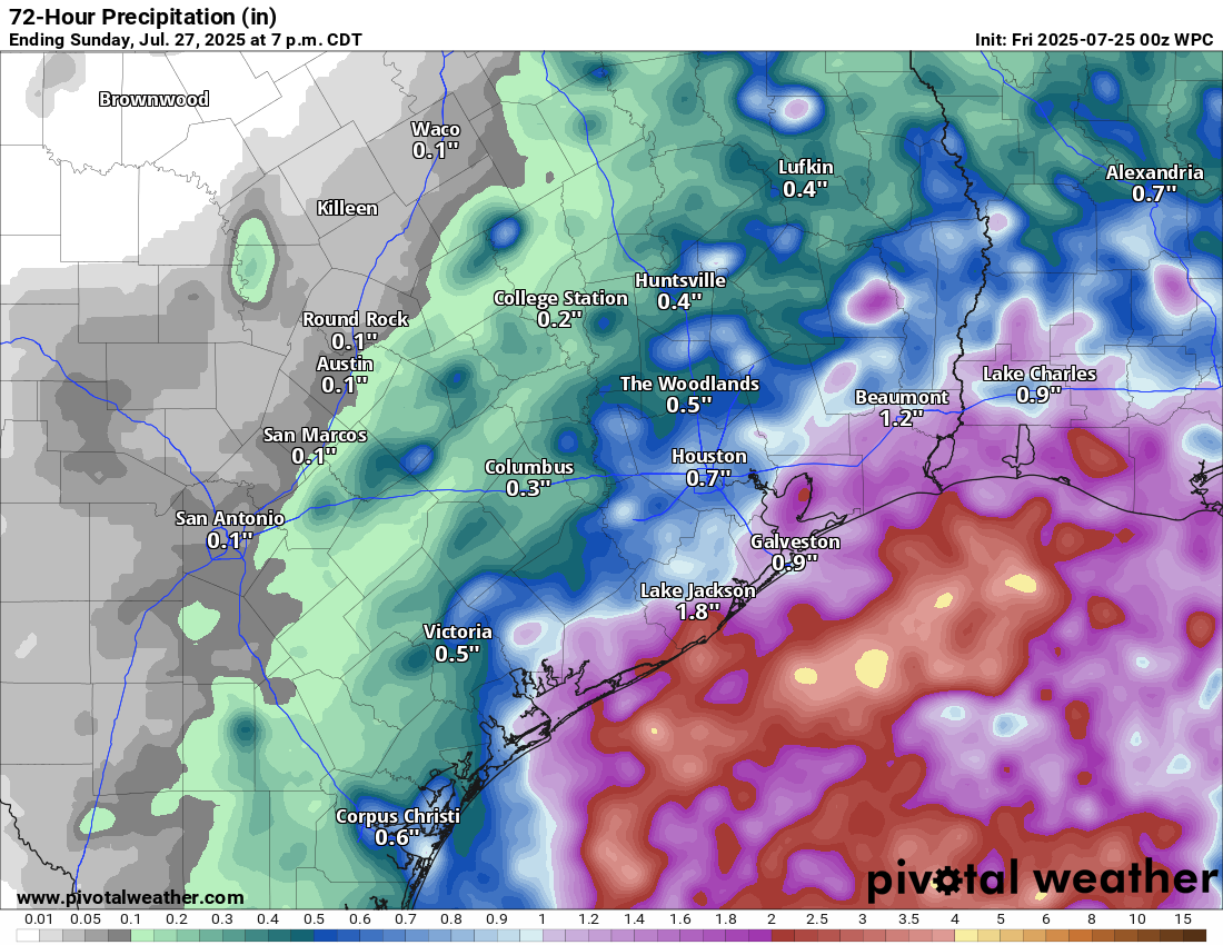
The disturbance in the Gulf that’s been carrying a 10 percent risk the last few days is at the end of the road. It will crash ashore in Texas today, bringing some downpours to the Houston area.
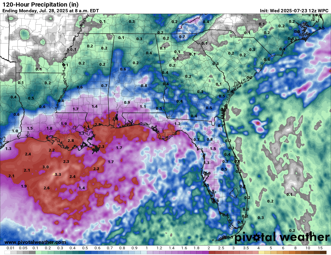
Forecast rainfall in the Houston area through western Louisiana today into Sunday. (Pivotal Weather)
Overall, this should be a manageable event, but perhaps one or two places will see some street flooding concerns crop up from Houston through Beaumont into Lake Charles.
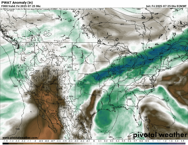
Interestingly, this system is going to continue to race west across Texas. Some of the added atmospheric moisture from it may get tired up within the monsoon pattern out West, which could lead to some enhanced moisture for New Mexico, Colorado, Arizona, and Utah.
Above normal atmospheric moisture (green) associated with the Gulf disturbance will work across Texas and get entrained into the monsoon pattern by Monday or Tuesday. (Pivotal Weather)
Otherwise, assuming nothing major changes, we’ll close the book on this one today.
What’s next in the tropics?
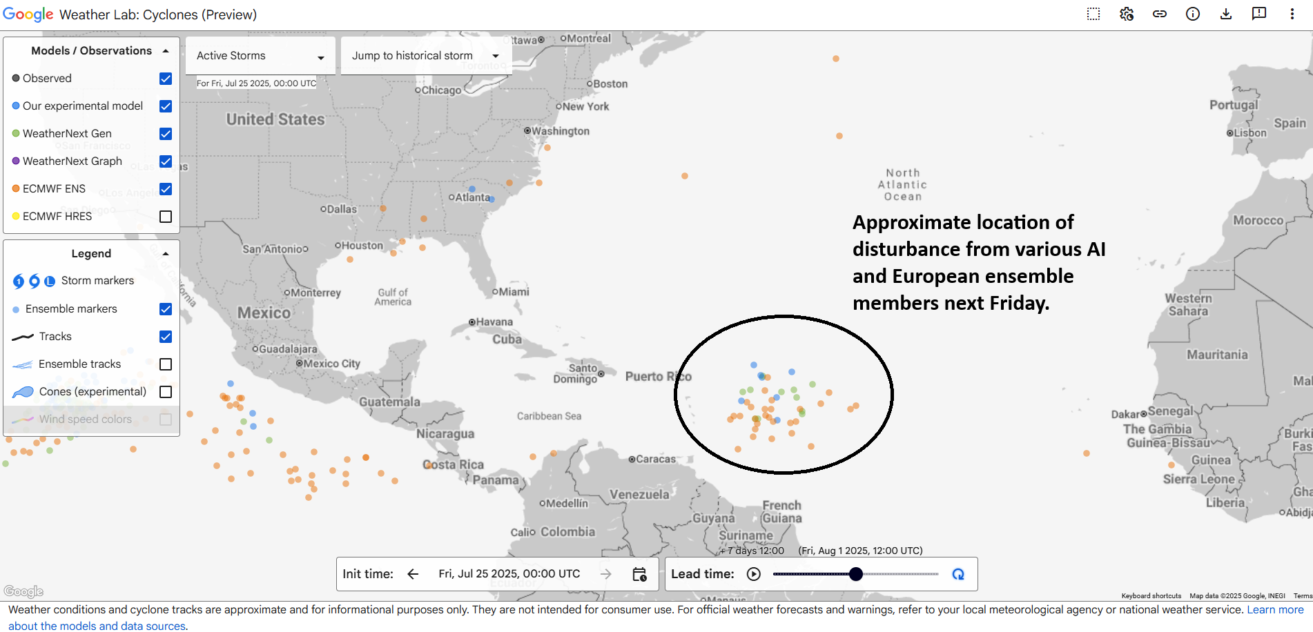
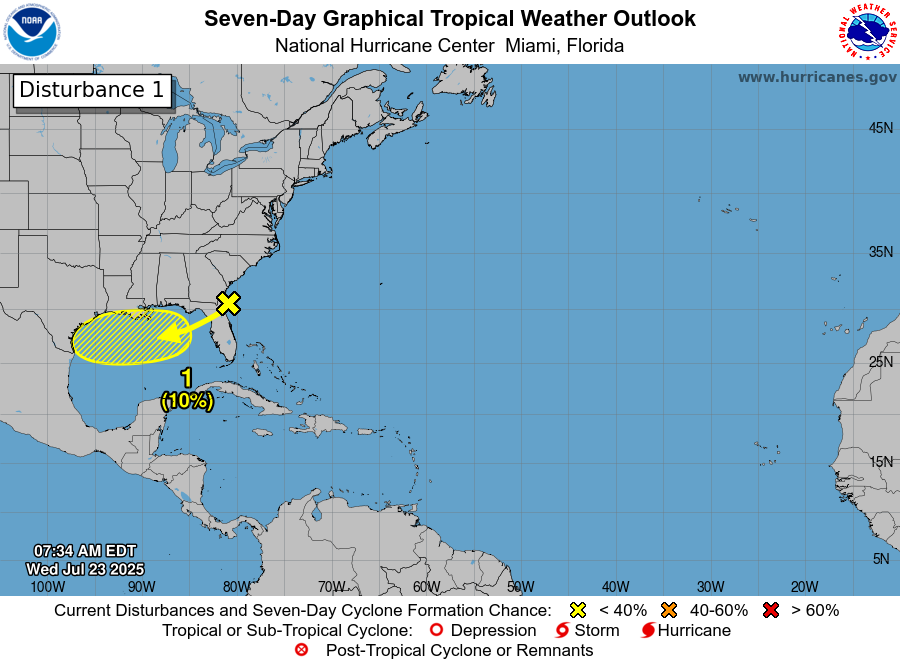
Well, it appears that we’re going to have our first true item to watch in the Atlantic next week. The system this past weekend only sort of counted. Next up, we’re watching models (and some of the usual social media suspects) get a little worked up about a tropical wave expected to emerge in the Atlantic next week.
Dots showing various European ensemble and Google AI ensemble member locations of tropical disturbance next Friday in the Atlantic. (Google Weather Lab)
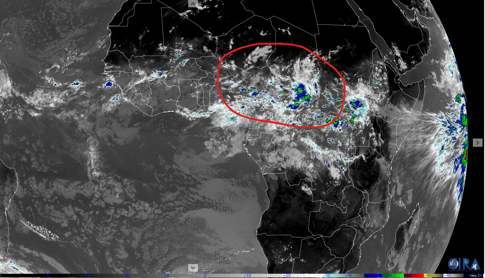
So, ok, that’s actually not terrible agreement for a 7 day forecast for a nascent wave that hasn’t developed yet. Where is this disturbance now? Wayyyyyy over Africa.
Area of thunderstorms over Africa that appears to be the disturbance to focus on for late next week. (Colorado State CIRA)
This thing has 2,000 miles of land yet to traverse before it even emerges in the Atlantic. And then from there, it’s got about 7 more days to get to the Caribbean. So, we’re at least 10 days out from something making it to the islands, let alone to the U.S. or elsewhere in the Western Hemisphere. So what can we say today? Models are latching onto a disturbance that has at least some chance to develop as it traverses the Atlantic later next week. But it’s far too soon to speculate on anything else, and thus, not worth hypothesizing or fantasizing about what may happen in 14 or more days.
Bottom line: We’ll keep watching and leave the rampant speculation to others.
Flooding risk focuses on Kansas and Missouri
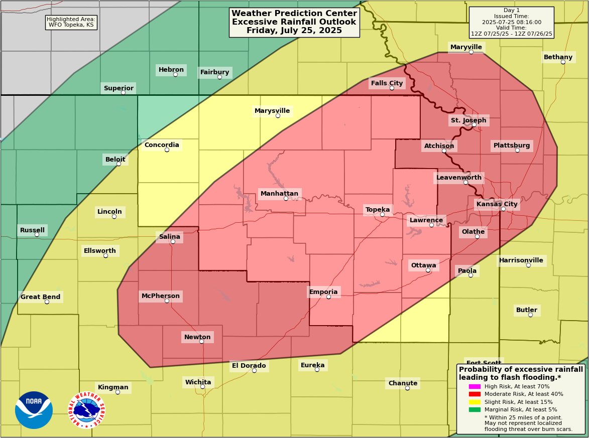
Some parts of Missouri and Kansas on either side of Kansas City saw anywhere from 4 to 6 inches of rain yesterday, with even some higher radar estimates. Those same areas are now in a moderate risk (3/4) today for excessive rainfall and flooding.
A moderate risk (3/4) is in place for flooding from north of Wichita through Topeka into the Kansas City Metro today. (NOAA WPC)
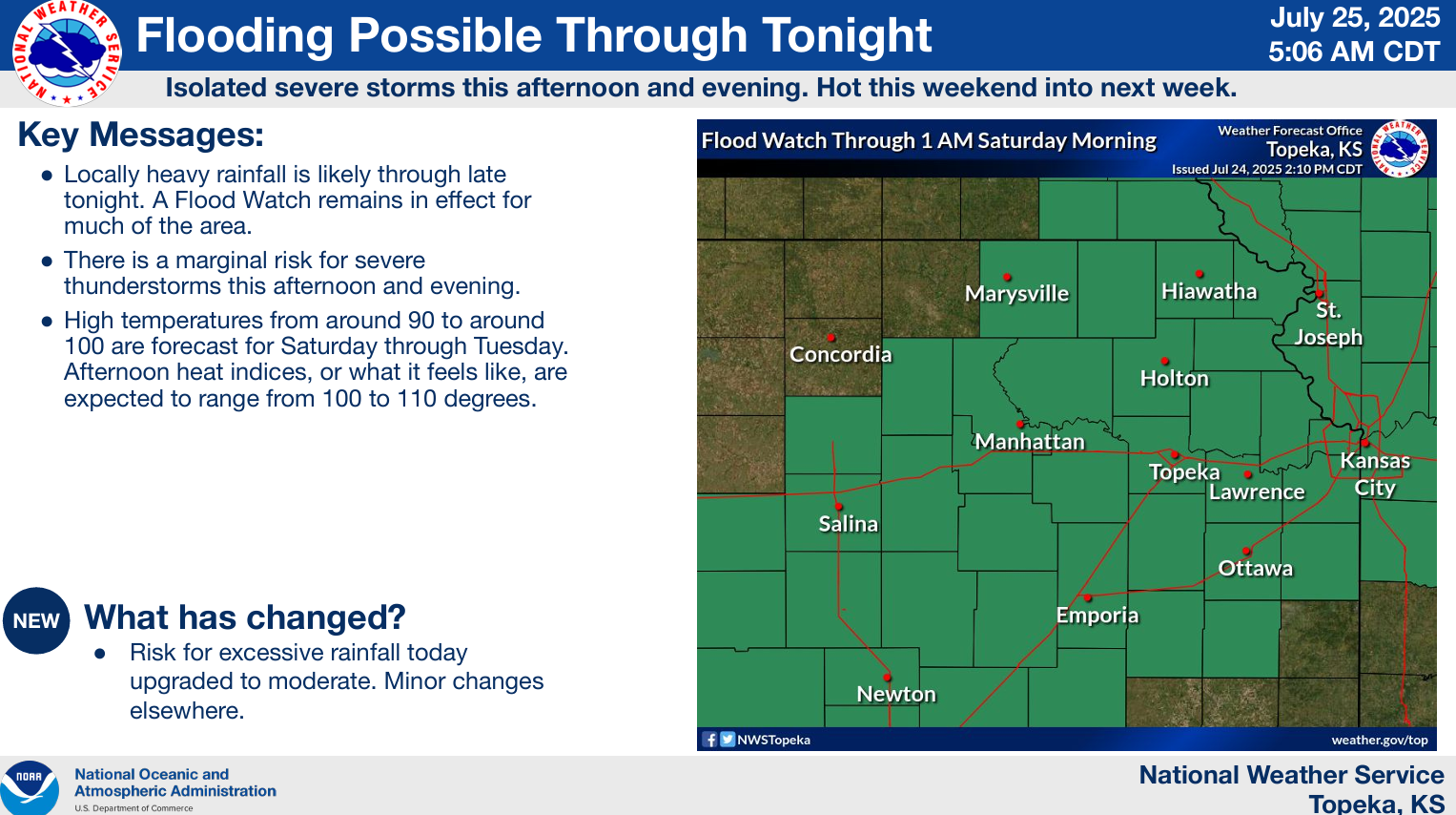
Flash flood warnings are already ongoing in some of these areas, including for the southeast half of the KC Metro. An additional 2 to 5 inches is possible in spots through the day today.
(NWS Topeka)
Showers and storms will wax and wane through the day.
In brief: No development is expected from the Gulf tropical disturbance, and while heavy rain is possible on the Gulf Coast, no serious flooding is expected either. There is a fairly healthy chance of at least some flash flooding today from New Mexico through Kansas and into the Chicago metro.
Gulf tropical update, participation award edition
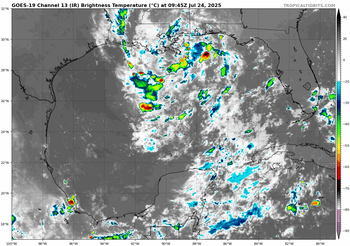
The Gulf tropical disturbance is maintaining about a 10% chance of development, and based on satellite this morning, even that may be somewhat generous.
A very disheveled and poorly organized tropical disturbance is near the coast southeast of Louisiana this morning. (Tropical Tidbits)
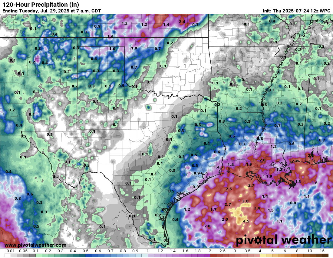
So, I don’t think this will be what gets us a tropical depression and/or Dexter. However, this will still bring some locally heavy rainfall to the Gulf Coast from Florida to Texas. At this point, the rain looks manageable in most places, and there are currently no Flood Watches posted. Still, we could see 1 to 3 inches of rain on the Gulf Coast from this.
Rain totals of 1 to 3 inches on the immediate coast are possible between Matagorda Bay in Texas over to Pensacola, FL. (Pivotal Weather)
This should probably be a mostly positive outcome for the coast, with the exception of perhaps a few places in Louisiana that have seen enough rain for a bit.
Flooding risk in the Midwest and Southwest
A place where there are flood watches? Eastern Kansas and Northern Missouri.
(NWS Kansas City)
Thunderstorms tonight into tomorrow could produce some impressive rain totals. You can see from yesterday evening how there was a good bit of spread in potential rainfall there near and north/west of Kansas City. That spread continues today, with pockets of the HRRR model suggesting north of 5 inches of rain south of Topeka and the HREF model showing potential of 3 to 5 inches in those spots.
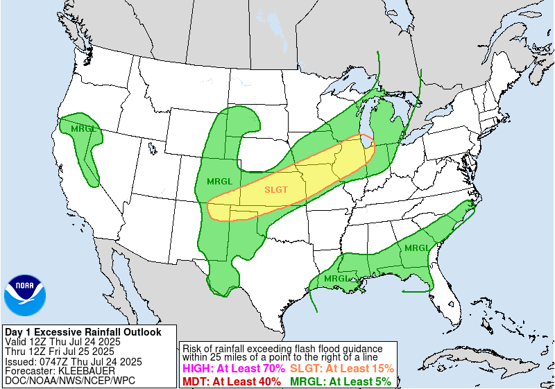
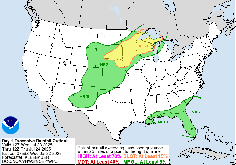
A broad slight risk (2/4) for excessive rain and flooding exists from New Mexico through Chicago today. (NOAA WPC)
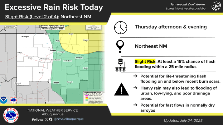
A slight risk (2/4) of excessive rain and flooding is in place for the Kansas City area and most of Kansas today. Another area with a flood watch is northeast New Mexico, where some flash flooding is possible near burn scars and in typically flood prone places like cities and arroyos.
(NWS Albuquerque)
The flooding risk will not move a whole heck of a lot tomorrow, mainly focused on Kansas, Missouri, Iowa, and Illinois.
In brief: The odds of a tropical system in the Gulf remain low, but we explain the evolution of things below. Also, we look at the ridiculous duration of flooding risks we’ve seen since June. We also talk about the ongoing and continuing heat wave and why despite not setting a bunch of records, it’s still a big deal.
Gulf tropical system
Late yesterday, the National Hurricane Center tagged the disturbance heading into the Gulf on their outlook map, giving it about a 10% chance of development. That still seems fair today.
(NOAA NHC)
Currently, the disturbance is very, very sloppy and spread out a good bit between the Gulf and off the east coast of Florida.
The majority of thunderstorms are about 300 miles west of the disturbance itself. (Weathernerds.org)
Wind shear in the Gulf is not exactly hospitable right now for development, as this disturbance will probably at least initially encounter a good bit of that. Wind shear tends to limit tropical development because storms prefer a less hostile environment in which to thrive.
But as this chugs west today and tomorrow, it may encounter a few periods of time where it will be less hostile, and that could lead to at least an attempt to organize. The only model suite right now that seems to be supportive of organization (and even in that case, it’s not particularly much) is the European ensemble. It seems to lack support from most other modeling, including the typically more aggressive ICON and Canadian models. Even in the Euro ensemble’s case, despite the ensemble mean showing 60 to 70 percent probabilities of a depression, only about one-third of members show any real organization.
The European ensemble is only a little more excited today about low-end development risk than it has been in recent days. (Weathernerds.org)
Yes, it’s the Gulf, and yes, you should probably check back in tomorrow to see if anything has changed. However, it seems unlikely that this will develop beyond tropical depression status if it gets there at all.
What it will do is drop some locally heavy rain along the Gulf Coast.
Rainfall this week looks to be locally heavy along the Gulf Coast. (Pivotal Weather)
Flooding concerns aren’t zero, but as we’ve noted this week there’s some breathing room here, and with a generally progressive moving system, rainfall amounts in any single location will probably be manageable.
So bottom line on the Gulf? Yes, something may try to briefly develop before moving into Texas on Friday. However, the ceiling is low and model support is extremely limited. The main impact from this system regardless will be locally heavy rain, and that should hopefully be manageable everywhere through Saturday.
It’s rain o’clock somewhere
The daily Weather Prediction Center excessive rainfall outlooks, or what we call the EROs are required consumption if you’re a meteorologist. Most of us look at them daily and read the discussions fairly regularly. The WPC does a phenomenal job at identifying and homing in on areas of excessive rainfall and flooding risk.
A slight risk (2/4) is once again in place today from the central Plains into Minnesota, Wisconsin, and the U.P. of Michigan. (NOAA WPC)
The risks are on a 4-level scale, from marginal to slight to moderate to high. Not that serious flooding can’t occur on a marginal risk day; it can, but typically, once you see the slight risks (2/4) or higher, you sit up a little more and pay a little closer attention. The last day that saw no slight risks of flooding was over a month ago, June 22nd. It has been non-stop somewhere in the country since then. One day it’s Texas, the next it’s the monsoon, the next it’s the Carolinas, after that it’s Iowa, then it’s New Jersey and New York City, etc., etc. Almost all corners of the country have been blanketed by a slight risk of flash flooding at some point in the last month. It has been exhausting for forecasters in many spots.
Today’s risk is highlighted in the Upper Midwest, once again a slight (2/4) risk. Some of those areas saw 1 to 3 inches of rain yesterday, and today’s forecast will probably lead to another 1 to 3 inches of rain.
Rainfall today and tomorrow should tally 1 to 3 inches more across Minnesota, northern Wisconsin, and Michigan’s Upper Peninsula. (Pivotal Weather)
Flash flooding is a possibility, as are locally higher amounts as some of these storms pass repetitively over the same areas.
Heat wave: All bark, no bite? It’s complicated
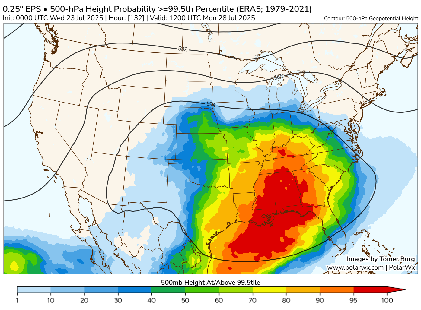
The interesting thing about this heat wave that’s ongoing across the country and likely to expand even farther afield next week is that very few record temperatures are being attained. Usually when you see a setup like this, you expect a fair number of records to fall. In reality, we’re getting the upper-level signal in the atmosphere of a pretty healthy heat wave. For example, if you look at the probability of 500 mb heights hitting the 99.5th percentile (or a high-end event) next Monday, you see a broad section of the Deep South, Mid-South, and Ohio Valley in play.
The European model’s ensemble probability that 500 mb heights will reach or exceed the 99.5th percentile is pretty high across the South on Monday. (PolarWx.com)
The 500 mb height is a good metric to use to analyze whether we see ridging or troughing, hotter than normal or cooler than normal. It tells us what the pattern is about 20,000 feet up, and for next week it says it’s gonna be hot!
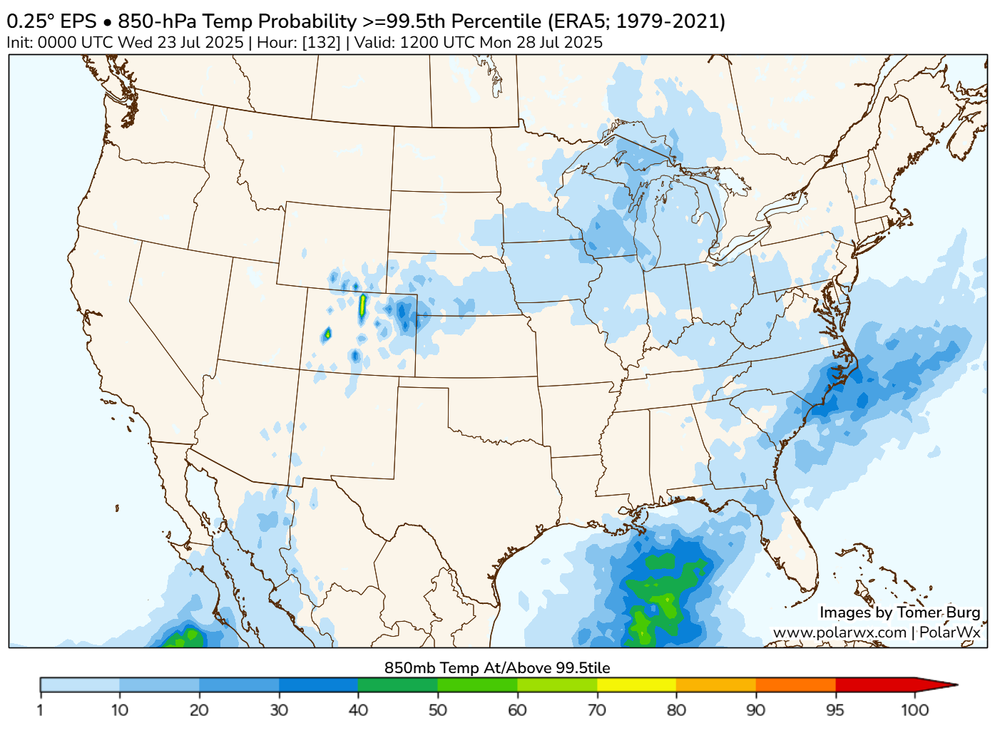
But then if you look at temperatures in the lower levels of the atmosphere, up around 5,000 feet, you can see that the potential for a 99.5th percentile (or a high-end event) is quite low.
The probability of 850 mb temperatures (or the temperature of the air mass about 5,000 feet up) reaching the 99.5th percentile on Monday is quite low.
So in theory, we have a couple conflicting pieces of information here. The upper pattern strongly supports heat, but the actual air mass we’re pulling from isn’t ridiculously hot for this time of year. The outcome? A lot of heat over a broad area, but very little record heat. I would also speculate perhaps that since we’re sitting right near the climatological peak of summer right now, it just is genuinely more difficult to see record highs. It’s hot during the hottest time of year; that’s not terribly abnormal.
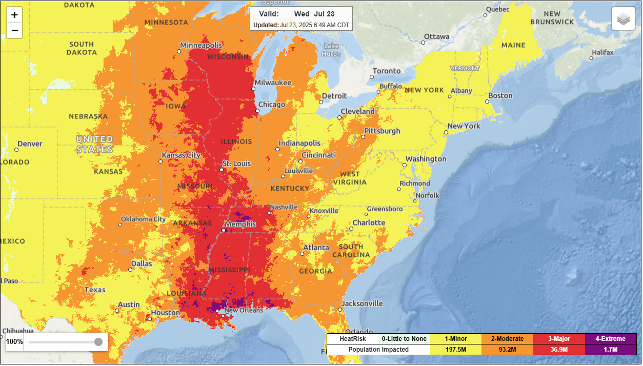
NWS HeatRisk for Wednesday has much of the Mississippi Valley under major to extreme levels of heat. (NOAA)
But the duration is what’s at play here. Multiple days of this type of mid-grade heat in a row plus humidity can take a toll on the human body, particularly in vulnerable communities, and that’s why it’s an important event to discuss and cover.
In brief: Invest 94L has bitten the dust in the Atlantic. A Gulf tropical disturbance shouldn’t develop, and it will be only a modest rainmaker for the Gulf Coast. Flooding risks focus on the Duluth area today with additional heavy rain chances on the periphery of the heat wave heading into next week.
Invest 94L outta here
In the tropics, Invest 94L is out of time in the open Atlantic. It’s been declassified, and the NHC has removed it from their outlook map this morning. It will soon run into a much too hostile environment for development, and at worst we’re looking at some added rain showers in the Windward Islands today and tomorrow. With that, we’ll close the book on Invest 94L. Thanks for playing.
Gulf tropical disturbance a modest rainmaker
The odds of a Gulf tropical disturbance becoming anything are so low right now that the National Hurricane Center isn’t even tagging it on their daily tropical weather outlook. But we’re focused on impacts, and while the impact from this disturbance won’t be substantial, it will bring a fair bit of rain to the Gulf Coast and Florida.
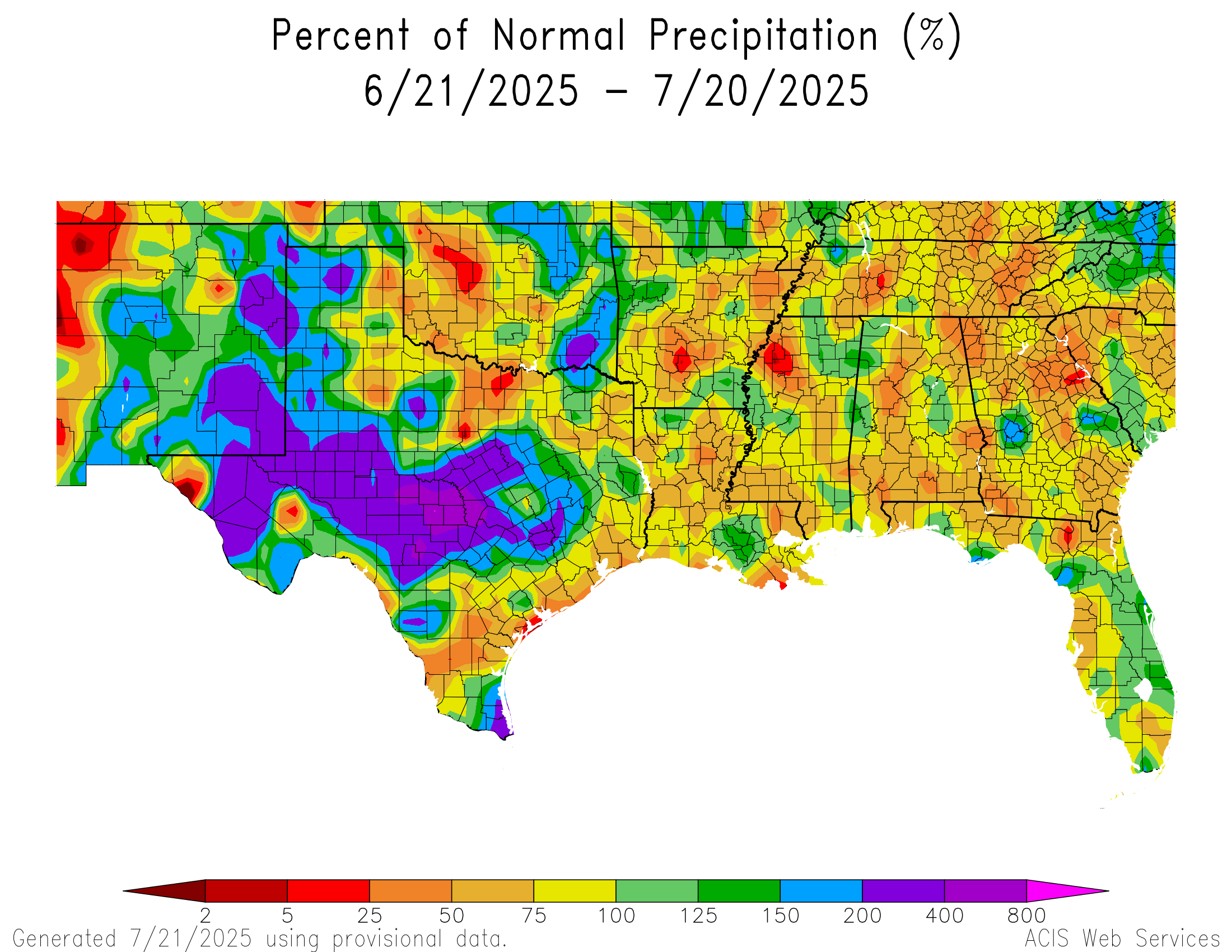
Rainfall has been surprisingly average along the Gulf Coast over the last 30 days. (High Plains Regional Climate Center)
While Louisiana has certainly seen a good bit of rain in the last week or so, and isolated pockets of Florida have been hit good, the majority of the region between Corpus Christi and Pensacola have been fairly blah over the last 30 days with nothing worse than isolated pockets of locally heavy rainfall. Rain totals increase some if you go back about 60 days, but still. Although there’s a good chance of some decent rain along the entirety of the Gulf Coast as the resurrected disturbance circles back in, there’s also a fair bit of breathing room to accommodate that rainfall in most cases. This should keep flooding concerns not at zero levels but relatively low.
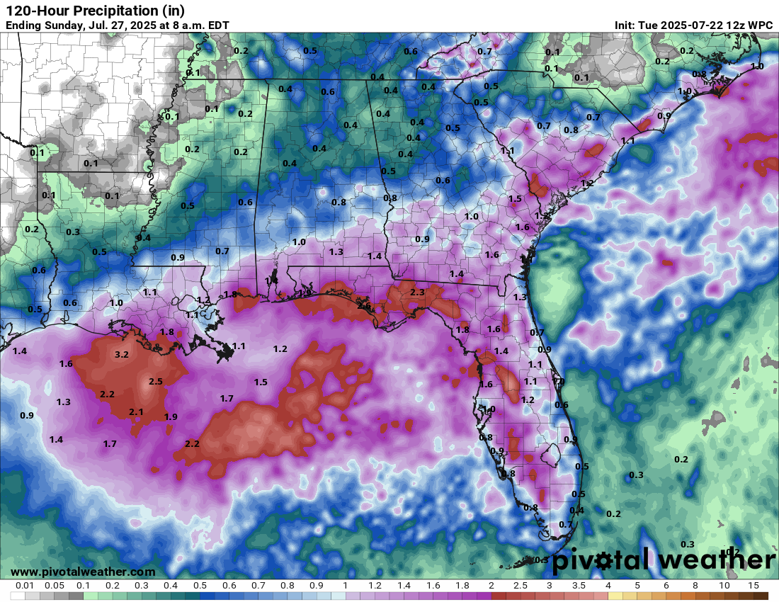
Rain totals of 1 to 3 inches over the next 5 days across the Gulf Coast should be manageable, with nothing worse than some localized flooding concerns. (Pivotal Weather)
The disturbance should barge into Texas at the end of the week, cooling down the Houston area and bringing widespread rain chances to East Texas and possibly some inland locales. Some of this moisture may survive all the way across Texas and get lumped in with the monsoon pattern in the Southwest, perhaps adding a small dose of extra precip for places like New Mexico next week.
Upcoming Central U.S. flooding risks and the “ring of fire”
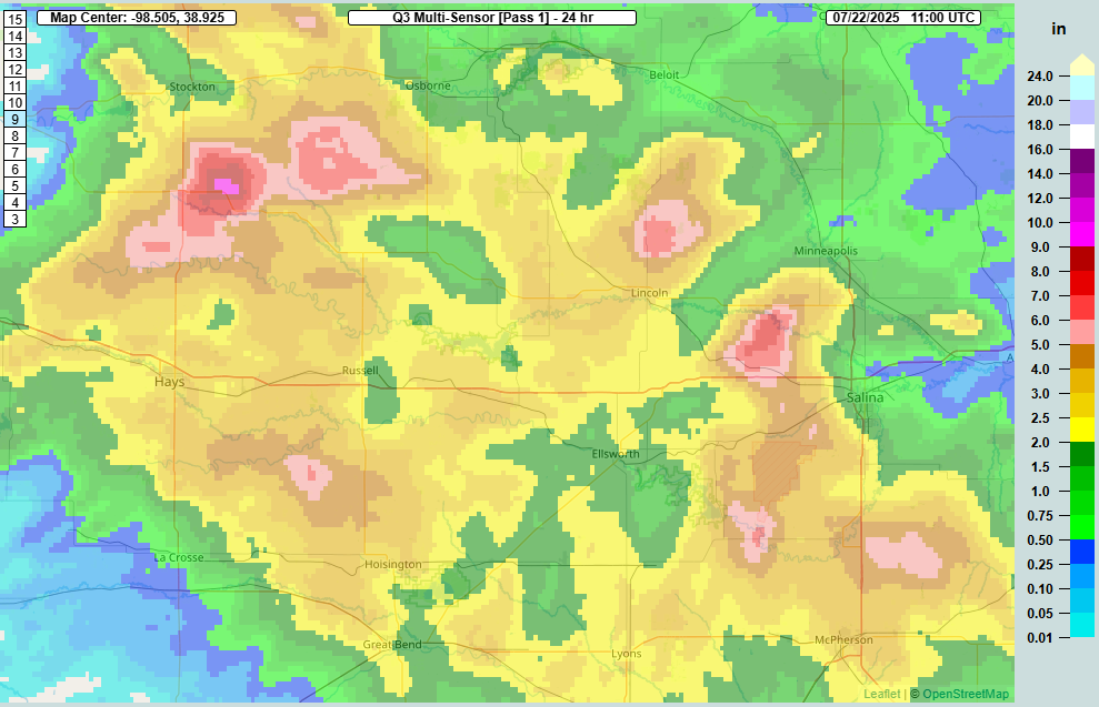
Even as dry weather is expected to take firm hold in the Southern Plains next week, Kansas got smacked with heavy rainfall yesterday, as rainfall estimates hit 3 to 7 inches or more from north of Hays to west of Salina.
24-hour rainfall estimates in central Kansas with pockets of 3 to 7 inches or even more from north of Hays to near Salina. (NOAA MRMS)
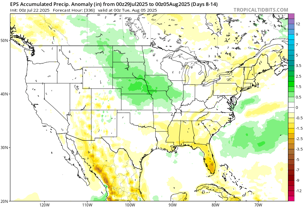
As ridging builds into the Southern Plains next week, look for the axis of some of these soaking rain events to shift northward, more into Nebraska or the Dakotas, particularly South Dakota. We’ll have to watch adjacent locations like Iowa and northern Missouri as well for flooding, as they have seen some substantial rains in the last few weeks.
Rainfall for days 8 to 14 looks above normal from Missouri and Iowa back into Nebraska and the Dakotas. (Tropical Tidbits)
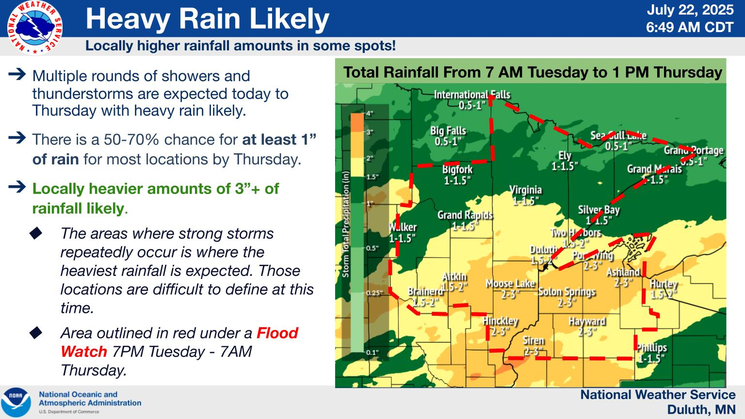
We may actually get an initial preview of this perhaps in Minnesota today and tomorrow, where weather models are pretty bullish on rain totals. Flood watches have been hoisted to include the Duluth area.
(NWS Duluth)
Storms will come in a couple waves between today and tomorrow up there. The flood story is not quite ready to go away.
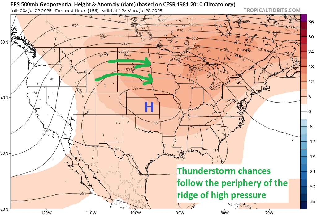
Basically, the setup for the heat wave continuing into next week will help initiate the storm chances on the periphery. Thunderstorms will tend to follow the northern fringe of the ridge, what we often refer to as a “ring of fire” in meteorology. Look for this to be the case next week as the ridge blossoms in the Plains.
The ring of fire, as we often call it will be in play next week in the Northern Plains and parts of the Upper Mississippi Valley. (Tropical Tidbits)
Thus, we could be talking both about some severe weather and a flooding risk in some of those areas.