September 11, 2023 Outlook: Lee turns north this week, with an out to sea escape scenario becoming increasingly unlikely

Just a quick note: We are aware of some email issues some of you are having where you get the post title and no other content. We’re investigating the reasons that may be causing this and hope to have a resolution soon. Sorry for any inconvenience!

One-sentence summary

Hurricane Lee should peak once again today or tomorrow before beginning a weakening trend but also a period that has it grow in physical size as it comes north, increasingly unlikely to turn out to sea.

Hurricane Lee: 120 mph, moving NW at 7 mph

Lee is wobbling between WNW and NW motion, which should continue through midweek before a more decisive turn north, passing west of Bermuda. (Tomer Burg)

What’s changed since yesterday?

Lee has re-intensified to a Category 3 hurricane with winds of 120 mph. It is expected to peak once more in intensity today or tomorrow before beginning a gradual weakening trend as it encounters more shear and cooler water temperatures. Lee’s track forecast continues to flop around some, keeping eastern New England through Atlantic Canada on guard for potential direct impacts late this weekend.

Lee’s intensity forecast

Lee is by no means a perfectly healthy storm, but it has gotten some of its act together since yesterday.

Sunrise on Hurricane Lee this morning shows a storm continuing to fight off shear and some dry air, trying to intensify further. (Weathernerds.org)

Lee became a category 3 storm again yesterday, and it’s likely in the middle of a gradual intensification cycle that should peak today or tomorrow. After that, Lee begins to encounter cooler water and more wind shear from an approaching upper level trough in the jet stream which should allow for steady weakening.

It’s important to note that just because Lee is unlikely to be a major hurricane at high latitudes, it does not mean that Lee will not be a significant storm. Its wind field is likely to expand as it comes north. So it will compensate for weakening by growing in physical size. Folks potentially in the path of Lee should continue to watch it closely.

Lee’s track forecast

It’s becoming increasingly unlikely that Lee is going to turn out to sea. Over the next 2 or 3 days, Lee will track generally west-northwest or northwest, before turning northward. Lee will be steered around the western flank of weak high pressure in the Atlantic and toward a trough moving through New England.

The upper level map on Thursday morning shows some of the things we’ll be watching to determine where Lee ends up, but the “out to sea” solution is becoming increasingly unlikely. (Tropical Tidbits)

The trough is going to play an increasingly important role in Lee’s future, with the exact intensity of it this weekend up for some debate. That will determine if Lee is captured closer to New England or more toward Atlantic Canada. That may also determine how big, broad, and strong Lee’s wind field is when it gets there.

Lee’s track forecast spread has actually *widened* a little since yesterday, but confidence in a track, loosely somewhere between New England and Newfoundland is increasing. (Tomer Burg)

The bottom line at this point: Folks from eastern New England to Newfoundland should be closely monitoring Lee’s progress. Any direct impacts from Lee are likely to not arrive until Saturday if it tracks toward New England or early Sunday if it tracks toward Atlantic Canada.

Potential impacts through midweek

In the meantime, we have rough surf and rip currents that are expected to overspread most of the western Atlantic this week. This will impact most areas in the Bahamas, Turks and Caicos Islands and north facing shores of Hispaniola, Puerto Rico, and the Leeward Islands. Bermuda will also see this occur, but we’ll be watching to see there just how close the core gets to the island. For now, I would anticipate we’ll see Tropical Storm Watches hoisted for Bermuda by late tomorrow or Wednesday.

Elsewhere: Margot and what’s next?

Tropical Storm Margot is likely to become a hurricane today as it moves generally due north. It will not impact land over the next 5-6 days, but it may get tied up in awkward steering currents in the open North Atlantic that could lead to it wandering about well into next week.

Margot is likely to become a hurricane tomorrow as it tracks north. Eventually it will slam on the brakes and probably meander for a bit west of the Azores. (Tomer Burg)

Off Africa, the next system seems most likely to follow (broadly) Lee’s track, which hopefully keeps it north of the Caribbean and eventually turns it out to sea. It will merge with Invest 97L. I’m not sure if the protocol will be to tag it as Invest 98L or keep the 97L label, but whatever the case it comes broadly west-northwest through the week, and the vast majority of model guidance keeps it north of the Caribbean.

Other than that, we see absolutely no signs of any Gulf or Caribbean activity through midweek next week, with wind shear mostly ripping in that part of the basin.

September 10, 2023 Outlook: Lee struggling and slowing down as it continues over the open ocean

One-sentence summary

While the final forecast for Lee is no clearer today than it was previously, there are some signs that we can begin to hone in on a region more likely to see Lee eventually.

Hurricane Lee: 105 mph, moving WNW 9 mph

What’s changed since yesterday?

Lee has continued to have to battle shear, and as a result it has weakened back to a category 2 storm with 105 mph winds. Lee has also slowed its forward speed down as expected by about 5 mph versus yesterday.

Lee continues to fight off some shear, which has helped weaken it back down to a category 2 storm today; still powerful but clearly not the same Lee from the other night. (Weathernerds.org)

Everything else is mostly on track as forecast.

Lee’s intensity forecast

I had sort of expected to see that Lee would organize a bit more yesterday evening, but that failed to materialize. Modeling suggests that shear may relax a little over Lee, but I’m wondering if that ever happens. The direction of the shear may change, which could, I guess, lead to some readjustment on the intensity outlook here. In general, modeling forecasts intensification again over the next 2 days or so before a slow weakening trend. Lee will probably compensate a bit for weakening by growing its wind field over the next week as it goes north.

Lee should begin to turn north on Tuesday or Wednesday, ending up west of Bermuda by late in the week. (Tomer Burg)

Lee’s track forecast

I’ll preface this by saying that confidence in Lee’s final outcome isn’t higher today than it was yesterday. However, there have been a few trends worth noting. First, the forecast track of Margot seems to have come into better agreement among models since yesterday, taking it more straight north than north-northwest. This tends to reduce the odds of an interaction with Lee. Perhaps one less variable in the equation then.

Second, there seems to have been a bit of a boost in agreement in Lee’s track as it comes north, or what I would say is “less spread” in the track. We now have ensemble modeling in moderate agreement on a track aimed broadly toward Nova Scotia late.

Lee’s track confidence is improving, slowly, with a broad N or NNW track toward eastern New England or the Canadian Maritimes by next weekend. (Tomer Burg)

Now, a few big things to note here. First, just because we now have moderate track agreement toward Nova Scotia does not mean a.) that Nova Scotia is the target for Lee when it comes north or b.) that impacts will not be felt far outside that track. The ultimate track of Lee continues to bounce around in both time and space. The timing differences have narrowed a bit today along the track of Lee, which means by tomorrow or Tuesday we can probably peg the timing of impacts a bit better. Secondly, while most modeling broadly points it to between Downeast Maine and Nova Scotia, it does not mean that Cape Cod or Newfoundland can unplug here. There is still a wide array of tracks and options, including a handful that try to nudge it back northwest toward even Long Island or southern New England.

So, we’ve been slowly “clearing” places from Lee, and I think today that may include North Carolina. Modeling shows this staying well east of North Carolina now, so from there south to Florida, this isn’t your storm. Bermuda? Still needs to watch closely. I would probably continue to watch this from Virginia to New Jersey, watching it fairly close from Long Island through Rhode Island, and watch it very close between Cape Cod and Newfoundland, including New Brunswick and Prince Edward Island.

Again, no one knows for sure where Lee will go. The best we can do is gradually narrow the focus a little. In the meantime, expect rough surf and rip currents to be prominent issues in the Bahamas, Bermuda, and up and down the East Coast this week. More on Lee tomorrow.

Margot and 97L

As I noted above, Tropical Storm Margot’s track is coming into better focus today. Margot is expected to go basically due north or maybe just slightly west of due north over the next several days. It is also expected to become a hurricane.

Margot remains a non-issue for land right now. (Tomer Burg)

Margot is still not expected to impact land.

Behind Margot, we have now established the new Invest 97L, which is located just west of the Cabo Verde Islands. Some operational modeling has gone wild with this one, bringing it to the Gulf or up the East Coast. We continue to not really see that as a major concern right now. We’ll keep tabs on 97L, but the odds of developing are only around 30 percent or so in the meantime.

Otherwise, the Gulf and Caribbean continue to look quiet for the next 7 to 10 days or longer.

September 9, 2023 Outlook: Lee fluctuating in intensity as it continues off to the west-northwest

One-sentence summary

Hurricane Lee will continue off to the west-northwest before turning northward east of the Bahamas/Turks & Caicos and heading off the East Coast and to the north.

Hurricane Lee: 115 mph, moving WNW 12 mph

Lee is expected to continue off to the west-northwest through Monday or Tuesday before turning northwest and then north-northwest, avoiding the Caribbean islands, Turks & Caicos Islands, and Bahamas. (Tomer Burg)

What’s changed since yesterday?

Lee has fluctuated back down to a category 3 hurricane, but there are some indications that Lee may be beginning another cycle of intensification today. Fluctuations up and down in intensity are expected over the next several days.

Lee’s intensity forecast

As noted, Lee has ebbed to a category 3 storm with 115 mph winds. It does seem as if it wants to begin another cycle of intensification, however, and the official NHC forecast brings it back up to a category 4 storm tomorrow or Monday. Lee is battling some wind shear right now, and it has taken on a rather ragged look, but per the most recent discussion from the Hurricane Center, it’s pretty evident that Lee still has plenty of punch. Reconnaissance flights were unable to get into the northeast eyewall of Lee this morning due to safety concerns around the thunderstorm activity in that part of the storm.

Lee is more ragged than it has been this morning, but that inner core is holding on, complete with an obscured eye and violent thunderstorms. (Colorado State University)

The shear is sort of a wild card with Lee right now. If it holds on more than forecast, Lee may sort of oscillate between category 2 and 3 intensity over the next few days. If the wind shear can relax enough, Lee would be capable of intensifying again back to category 4 or so. The NHC has taken this into account in their forecast, which shows some strengthening in the near-term, followed by a drop in intensity late.

Regardless of “what” Lee is, it will remain a potent storm over the next 5 to 7 days. Rip currents and rough surf will be a feature along the U.S. East Coast, Bermuda, the northern Caribbean islands, and the Bahamas. Eventually the rough surf will make it to Atlantic Canada as well.

Lee’s track forecast

Everything is in line with what has been expected through early next week, which is to say that Lee should comfortably avoid the Caribbean islands and avoid the Turks and Caicos Islands as well. While there is still a bit of uncertainty on exactly where Lee will turn northward, there is *strong* model agreement that it will occur before Lee gets close enough to bring direct impacts to the southeast Bahamas and Turks & Caicos Islands.

If you live in Florida, you remain in the clear from Lee and do not need to worry about this storm. Easier said than done, I know, but no reliable modeling shows Lee coming remotely close to making it that far west.

Farther up the East Coast, we have little to no additional clarity today on Lee’s future track. The good news I guess is that we do have confidence that Lee will turn northwest, north-northwest, north, and eventually north-northeast. But exactly how that happens remains to be seen and everyone from about Delmarva through Atlantic Canada, as well as Bermuda should be continuing to monitor Lee’s progress.

Lee’s track forecast track density remains elusive after it makes the northward turn. Significant timing differences among modeling leads to low confidence on exact track, intensity, and timing of impacts. (Tomer Burg)

The map above shows track density, or roughly how many of the dozens of ensemble members agree on where Lee will go. Notice that the confidence is actually moderate that Lee will turn north and end up somewhere west of Bermuda. But from there, confidence drops.

One of the biggest problems right now is timing. We know Lee will slow down once it gets just east of 70° longitude. How fast does Lee come north? There is significant, massive model disagreement on timing of that speed once the turn gets made. For example, the European ensemble’s 51 members (not shown) have the center of Lee anywhere between just east of Cape Hatteras to north of Prince Edward Island next Saturday. That is roughly a 1,000 mile along-track spread. So we have high confidence in the turn, high confidence that it will go northward and pass just west of Bermuda but low confidence in how quickly it goes north, and that has implications on what to expect if you live in Halifax or Boston or Montauk.

I will say, it appears that the threat of direct impacts is fairly low right now from Long Island into the Mid-Atlantic. You should still monitor things, but the consensus view of modeling is that Lee will pass to the east of the areas hard hit by Sandy. New England? A slightly different story, as there is still a good deal of modeling bringing Lee close to Cape Cod or the islands. Still, most of it keeps it east, but it’s close enough. Maine and Nova Scotia into western portions of Newfoundland may be most at risk in the current environment. Again, the timing and intensity and exact track are impossible to nail down right now. But you can plainly see above that modeling is skewed right now toward the Maritime provinces.

We’ll continue to keep you posted.

Elsewhere: Margot and the MDR

Tropical Storm Margot continues to plod along in the open ocean.

Margot is a low-end tropical storm that should become a low-end hurricane in time. It will remain out at sea. (Tomer Burg)

Margot has a good bit of warm water to work with over the next 3 days, so it should intensify close to hurricane strength before it approaches the cooler waters of the North Atlantic. Margot remains a bit of a wild card in terms of Lee’s track and we’ll likely be talking a little more about this storm later next week.

There continue to be some hints of another wave emerging off Africa and trying to make a go of it in the Atlantic Main Development Region (MDR) next week. As of now, there is not much else to say about that storm except that we are likely to see some outlier solutions on operational model guidance, so try not to read into that too much. Most reliable data says that this will be a slow developing system and may even struggle some.

September 8, 2023 Outlook: Lee’s exceptionally rapid intensification makes it a category 5 in the open Atlantic

One-sentence summary

Hurricane Lee has rapidly intensified into a powerful category 5 storm, and while it will not threaten land for at least a week or so, it will stir up rough surf and rip currents from the Caribbean to the East Coast of the U.S. in coming days.

One-image summary

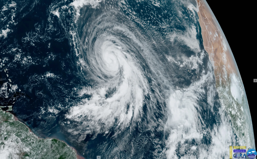
Hurricane Lee around sunset on Thursday as it was in the middle of its rapid intensification to category 5 intensity. (Colorado State University)

Hurricane Lee: 165 mph, moving WNW 14 mph

What’s changed since yesterday?

Lee went from an 80 mph storm yesterday to a 165 one today, an extraordinary rate of intensification that places it on the leaderboard in recent years. Lee is on the cusp of being one of the strongest Atlantic hurricanes on record.

Lee continues west-northwest, and while models continue to agree on an eventual northward turn, the timing, speed, and location of that turn will be important in determining the next steps next week.

Lee is expected to maintain its current trajectory through the weekend with a gradual decrease in forward speed. (Tomer Burg)

Lee’s impacts through the weekend

Lee will not directly impact any land mass over the next few days. But it will make itself known. Large swells generated from Lee are expected in the northern Caribbean, including Puerto Rico and eventually Hispaniola, the Turks and Caicos Islands, and the Bahamas. Rough surf and very strong rip currents are expected, so if you live in these areas or are planning to swim in these areas this weekend or next week, please be very, very cautious.

Swells will build and begin to impact the U.S. East Coast, Bermuda, and eventually the Canadian Maritimes, probably building from south to north beginning around Sunday. Much of next week will feature rough surf and strong rip currents on the Eastern Seaboard.

Lee’s intensity forecast

We should be seeing peak Lee today. Normally, category 5 storms do not stay there. They become vulnerable to internal and some external forces that can cause them to fluctuate in intensity, sometimes considerably. Lee could Sisyphus its way along the intensity scale tonight through Sunday.

Beyond that, Lee is likely to drop back a notch, probably fluctuating between category 2 and 4 intensity next week as it turns the corner off the East Coast. Certainly still a powerful storm but not quite peak intensity. As Lee further gains latitude later next week, it should weaken further, but in compensation, it could expand in size or increase its forward speed some. Its impacts would still not be that of a category 5 in terms of wind, but it will be capable of causing problems should it make it to land or close to land.

Lee’s track forecast

We have little clarity on Lee’s track next week, except to say that it still is likely to miss to the east of Florida, Georgia, and South Carolina. As Lee advances forward, it will slow down. When Lee gets to a point somewhere just northeast of the Turks & Caicos Islands or southeast Bahamas, we will see it possibly slow to a crawl. This should occur Monday and Tuesday.

Lee is going to slam on the brakes just northeast of the Turks and Caicos Islands. The shift in color from red to yellow/green indicates the high uncertainty in exactly where Lee turns north. Forecast confidence plunges at that point right now with a wide berth of options ranging from just off the East Coast to out to sea. (Tomer Burg)

Lee will then turn hard to the north. Beyond that point, Lee will be fighting a battle with a trough (dip in the jet stream) over the Eastern U.S., high pressure to Lee’s east, likely-Hurricane Margot, and a fairly substantial area of high pressure that establishes over Newfoundland. You can see those features on the map below. Again, the placement and intensity of these features will determine if Lee goes toward New England, toward Nova Scotia, out to sea, or out to sea and toward Bermuda. But it is clear that any direct land impacts would probably not occur until the end of next week or even next weekend.

Lee will be directed by the exact placement of an East Coast trough, high pressure north of Bermuda into Newfoundland, and Margot’s location. Nailing the forecast of all of these is imperative to figuring out where Lee goes. (Tropical Tidbits)

I’m curious about two things today. First, the ridge north of Bermuda extending up to Newfoundland may be a key to all this. It’s going to essentially narrow the escape route. If that were not there, we’d likely see Lee get picked up and ushered out to sea, no problem. With that exit door now cracked instead of wide open, I just get the sense that this is not going to exit easily.

Second, how will Margot and Lee interact? Last night’s operational European operational model showed an interesting scenario where the two systems come close to interacting with the Fujiwhara effect. In that scenario, Lee could theoretically be forced to go a bit to the east and Margot a bit to the west. There is a trivial but not impossible scenario where Lee gets directed away from land or a specific land point because of this.

More importantly, all of this underscores just how difficult predicting Lee’s end game will be for another few days at least. It’s a good time to review your hurricane plans if you live along the Mid-Atlantic or New England Coasts or in Canada to be safe, but we have a long, long way to go here.

We will keep you posted each day this weekend on forecast developments.

Margot makes a splash

Tropical Storm Margot formed yesterday in the far eastern Atlantic. It will not be a threat to land over the next week.

Tropical Storm Margot is expected to become a hurricane next week over the open Atlantic. (NOAA NHC)

Margot is expected to become a hurricane, another feather in the cap of those who predicted an active season this year. As noted above, we’ll watch to see if it can’t have influence on Lee’s eventual track outcome late next week.

Anything else?

Nope. The basin, at this point looks as though it should quiet down a bit outside of Lee and Margot. No new systems are expected for most of next week, although some recent GFS and Euro ensemble runs are trying to spin up another Cape Verde system late in the week. Nothing else we need to fret over right now, however.