Debby is causing localized catastrophic flooding in parts of northern Pennsylvania and the Southern Tier of New York.
Debby’s remnants will exit into Canada tonight, bringing more flooding risks to Quebec, including Montreal, as well as northern New York and northern Vermont.
The next wave has increasing development odds in the Atlantic.
While no development is expected before Monday, interests in the Leeward Islands, Puerto Rico, and Virgin Islands should monitor this wave’s progress closely.
Debby on the way out
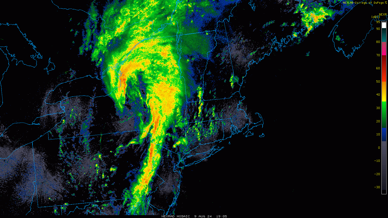
Debby, no longer a tropical storm, is exiting to the north today, but not before leaving more destruction in its wake. Several flash flood emergencies are ongoing in Pennsylvania and New York this afternoon as Debby’s rains lead to damaging flooding, including reports of rooftop rescues and numerous trapped people in Westfield, PA.
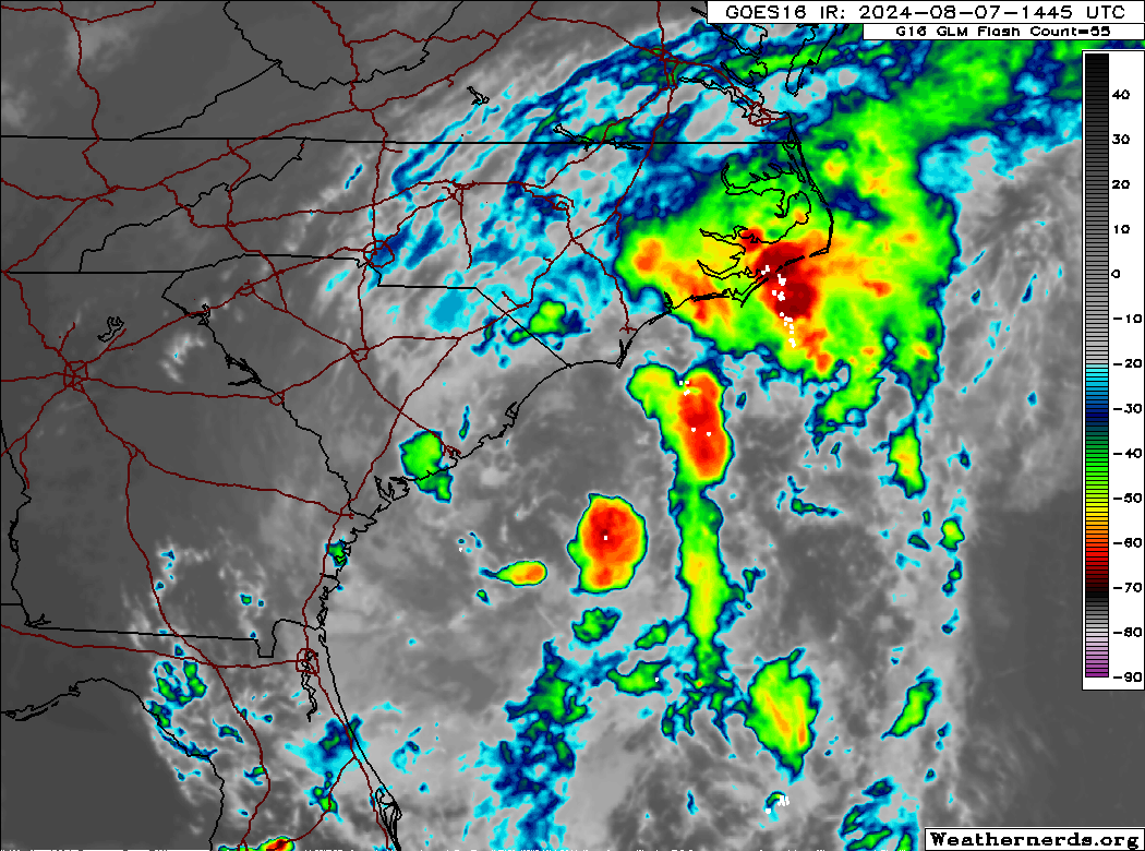
Debby’s remnants lifting through Upstate New York this afternoon. (College of DuPage)
Debby’s remnants will move into Canada and bring more flooding rain, with rainfall warnings hoisted for much of southern Quebec and parts of New Brunswick as well. Portions of northern Vermont, very vulnerable to rainfall are also under a flood watch as Debby’s rains move that way. Isolated tornadoes are possible as well.
Watching the next wave’s development odds increase
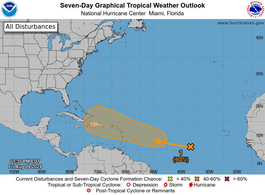
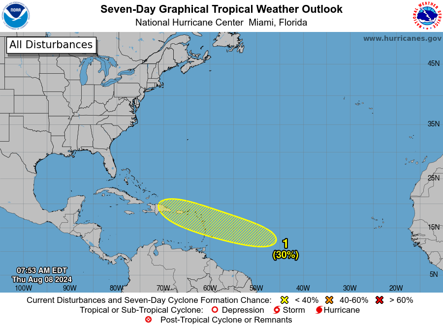
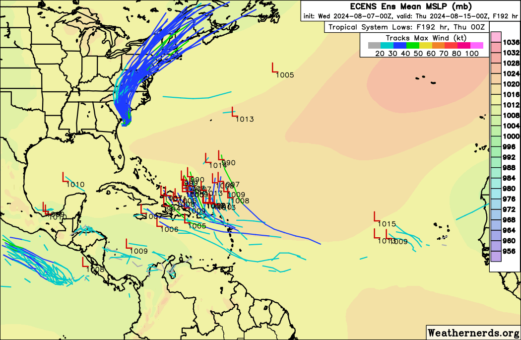
As I noted yesterday, I felt that the 30 percent odds of development from the next Atlantic wave were going to increase. A little over 24 hours later, and those odds are now doubled up to 60 percent.
The next tropical wave is up to 60 percent odds of development by next week. (NOAA NHC)
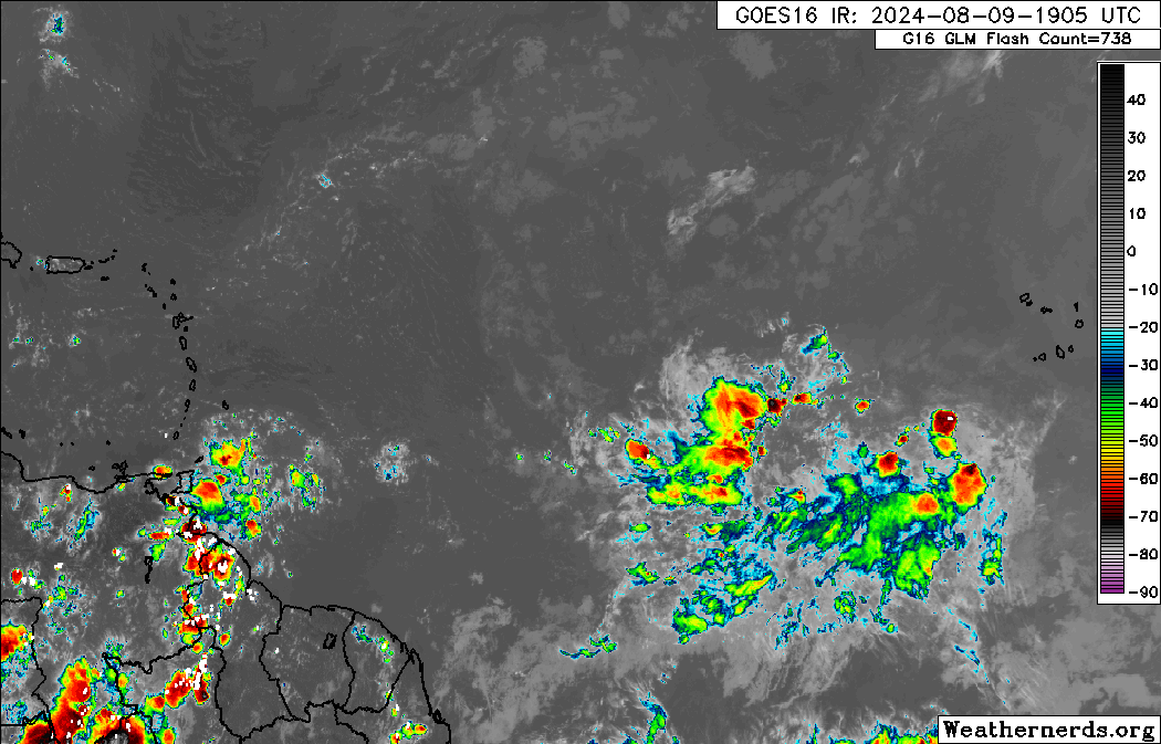
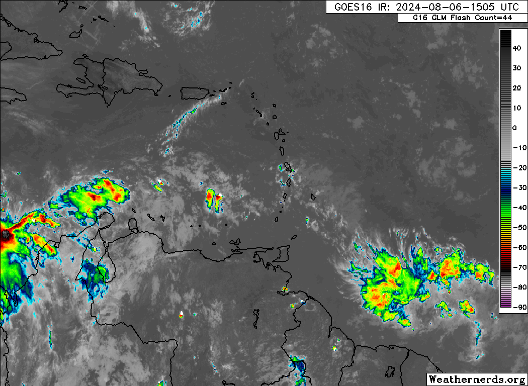
The tropical wave itself is not much to look at today, just an area of clouds, showers, and thunderstorms in an otherwise rather dusty Atlantic. You can see it east of the islands on the satellite image below.
The next wave looks disorganized but holding thunderstorm activity as it rambles west across the Atlantic. (Weathernerds.org)
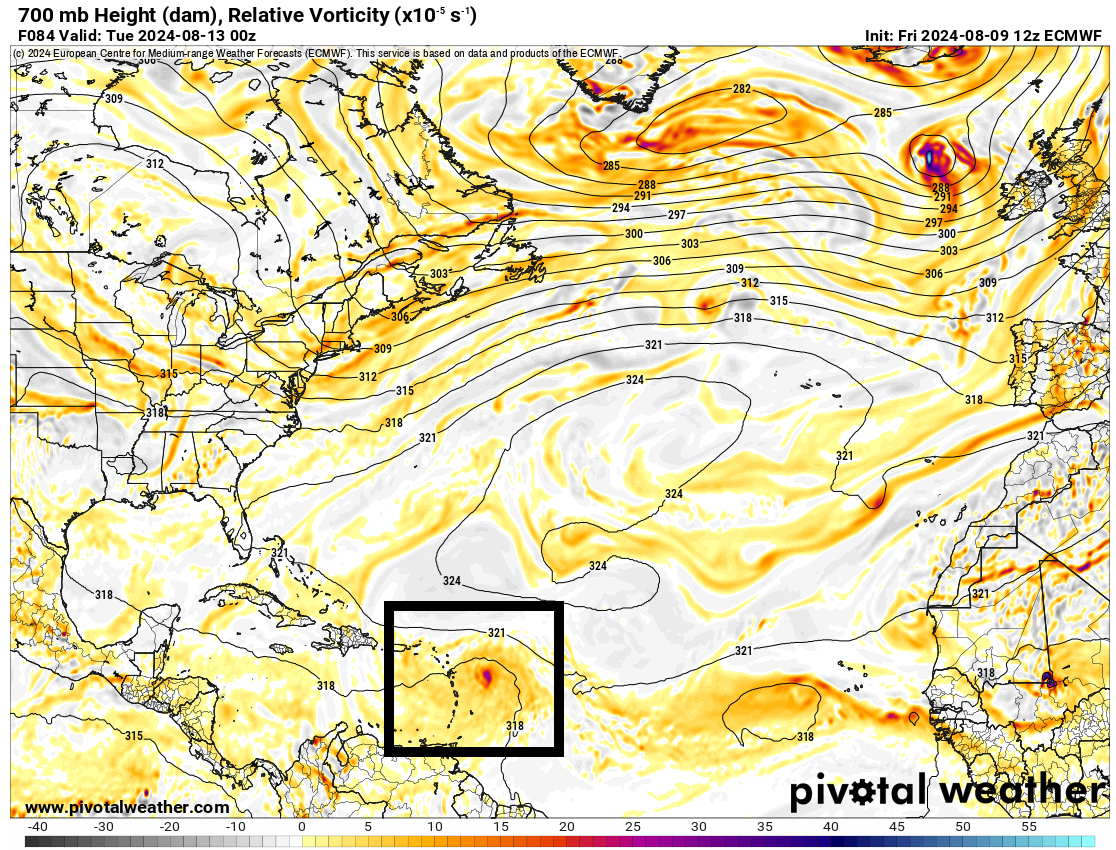
The first thing I can tell you about this one is that we do not expect any development probably before later Monday. So we have a couple days yet before this gets started. So for folks in the islands, this will probably not be bearing down on you as a big storm; it will probably just be getting organized as it arrives. Whatever the case, by Monday, we have a tropical wave on the cusp of organization, arriving just east of the Lesser Antilles and Virgin Islands.
The tropical wave will be arriving near the islands on Monday afternoon or evening, just likely beginning the process of development. (Pivotal Weather)
From here, the ballet begins. High pressure over the Southern U.S. and Texas, a trough digging into New England, and high pressure in the Atlantic will compete as this wave develops to help steer it. The current majority of modeling suggests this will develop steadily enough that it will probably go north in the islands and eventually into the open Atlantic. However, given that we’re about 6 days or so out from that happening and the inherent uncertainty from an undeveloped system, we can’t say much for sure. Here’s what we can tell you today:
The tropical wave is unlikely to develop before Monday.
Development may occur steadily, if not rapidly as the system enters the Caribbean or grazes the northeast Caribbean next week.
While the model consensus suggests an eventual north turn well off the East Coast, it is far too early to say much about this system’s future track.
A Gulf of Mexico track is unlikely at this time but not an impossibility.
I feel like when storms have had an opportunity to come a little farther west than expected this season, they’ve found a way, so I don’t want to write this off for Florida or the East Coast just yet. Right now, folks in the Leeward Islands, Puerto Rico, and the Virgin Islands should be watching this system closely, as once it gets going, it could start organizing fairly quickly. Beyond that, stay tuned this weekend for the latest. We’ll have another update for you on Sunday.
Debby is moving inland across South Carolina, spreading heavy rain and flash flooding across the Carolinas.
Significant rain and flooding will continue in North Carolina and expand into Virginia today.
Debby lifts north and exits tomorrow and Saturday, spreading flooding risks into Pennsylvania, New York, and Quebec.
The next tropical wave to watch will arrive near the Caribbean islands early next week, and it will be worth watching closely.
Debby brings widespread flooding northward
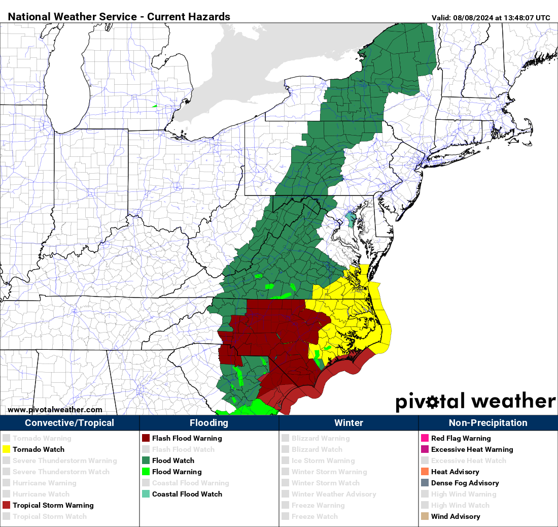
Tropical Storm Debby has come back ashore today near Bulls Bay, SC, which is just north of Charleston. It continues to slowly migrate inland and will lose wind intensity through the day. One thing it won’t lose is moisture, and virtually all of east-central North Carolina and northeastern South Carolina is under a flood warning this morning. Just a huge spatial area of flash flood warnings.
Flash flood warnings in maroon cover a massive chunk of North Carolina, including Raleigh-Durham, the Triad, and Charlotte. Flood watches extend north up the Appalachians into Central and Northern New York. (Pivotal Weather)
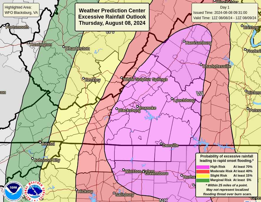
That heavy rain will migrate northward today into Virginia, where a high risk of flooding (level 4/4) extends up through Roanoke, Blacksburg, Lynchburg, and Charlottesville.
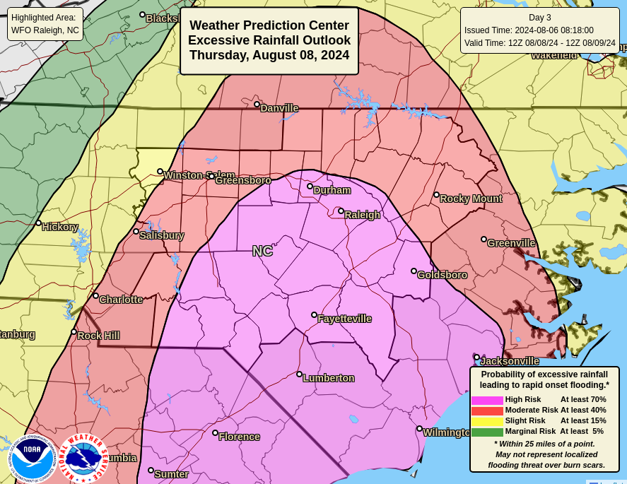
A high risk (level 4/4) of flooding exists again today, this time from North Carolina into the Shenandoah Valley. (NOAA WPC)
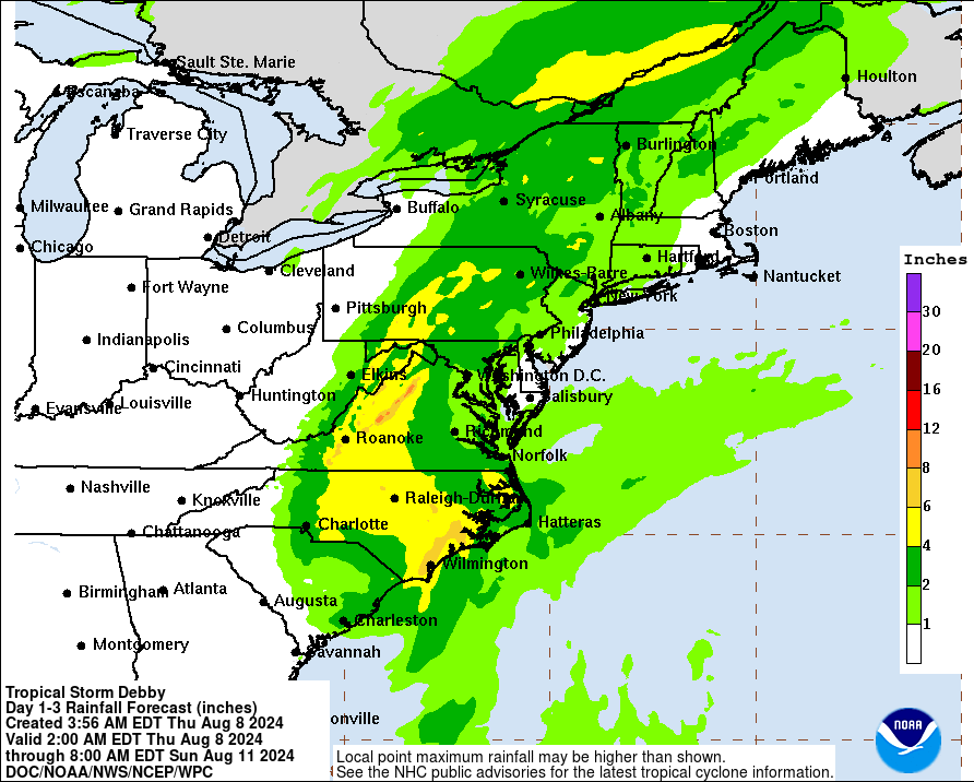
Heavy rain will expand north into Pennsylvania and New York as we go into tonight and tomorrow, as well as into Quebec. Basically, we’re looking at 2 to 5 inches over a wide area, with isolated enhancement in the mountains of Virginia, where the flooding could be the worst. Everything should exit late tomorrow. Some additional heavy rain will be possible east of the this peak axis, but it will be a more manageable rain. Severe weather, including isolated tornadoes are possible too.
Peak totals will basically follow I-81 north into Upstate New York, with another maxima in the St. Lawrence Valley in Quebec, mainly east of Montreal. (NOAA WPC)
And we’ll say goodbye to Debby after this.
Next wave up is increasingly intriguing
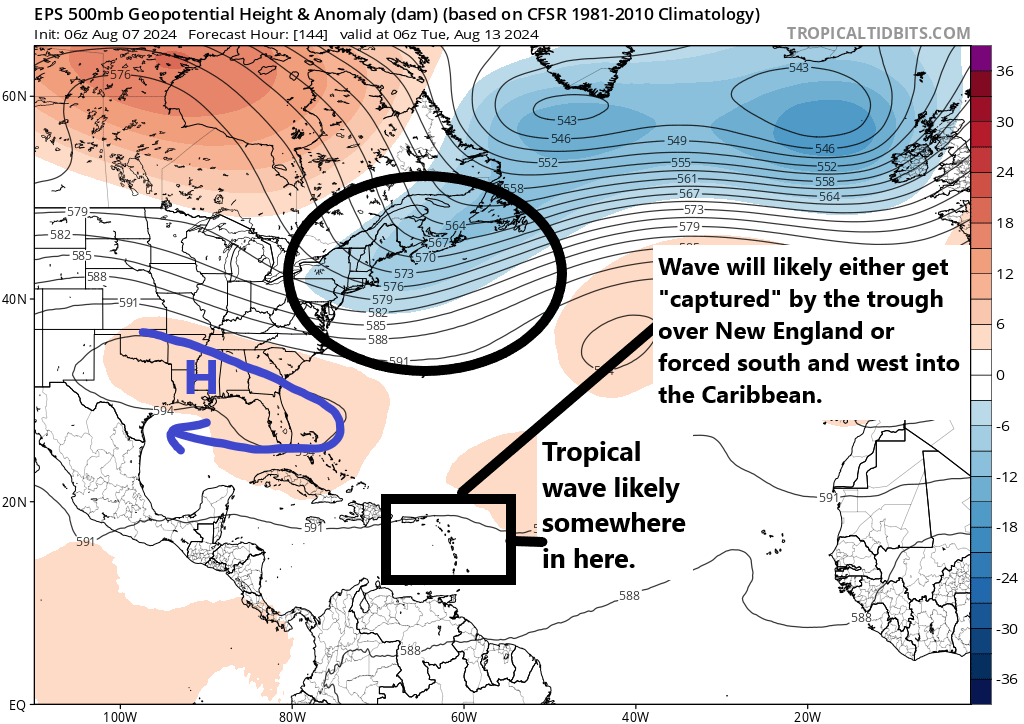
As I noted yesterday, while modeling was mostly leaning toward the next wave not being a big deal, there was reason to watch it. It has indeed been added to the area of interest map today by the National Hurricane Center.
The next tropical wave to watch will arrive near the islands in 4 or 5 days and currently has about a 30 percent chance of development. (NOAA NHC)
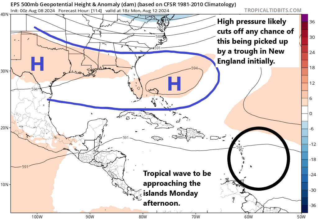
They open the bidding at 30 percent, but I truthfully think we’ll see this increase some in the next day or two. This wave is going to have an interesting future. First off, development with this one will be slow. There is a lot of Saharan dust to contend with in the Atlantic, and there is no reason to think we see much of anything through the weekend. By the time we get to Monday, the wave should be approaching the Antilles. At this point, development may start to unfold slowly. But with high pressure basically in control from the Bahamas into Texas, this system will probably be cut off from “feeling” the tug of a trough in New England initially.
A slowly developing tropical system is likely to move into the islands and/or Caribbean early next week. (Tropical Tidbits)
From this point, it becomes a bit of a fight. If this system struggles a bit, it will stay suppressed, likely south of Puerto Rico and Hispaniola. This means it may miss its ride out to sea from the deepening New England trough. However, if development starts moving along more aggressively, we will likely see this system gain latitude toward Puerto Rico and Hispaniola or to the north, making it more likely to ultimately be captured by the New England trough and sent north. Additionally, the specific location and strength of the trough and areas of high pressure will play a big role too. It’s far too early to say how this ballet will play out, but I have to admit, the model data today was a little more sluggish with the pull north, which starts creeping this system a little farther west than we’d care to see.
In terms of timing, impacts will arrive in the islands early to mid next week, and if they come west toward Cuba, the Bahamas, or Florida, it would be late next week. Any risk to the Gulf, if any, is unlikely before at least next weekend. We have a lot of time to watch.
Additional waves may try to get going off Africa around the 20th, but we’ll see.
Debby will cause heavy rain and more flooding in parts of the Carolinas today and tomorrow.
By Friday, Debby’s rain and flooding will expand northward to Pennsylvania, Central New York, and northwestern New England, as well as Quebec.
The Caribbean wave we were watching has been taken off the board and should not develop.
We are watching some other areas in the Atlantic later into next week.
We also introduce our sponsors page!
Debby readying to come back ashore — slowly
You might be confused when looking at Debby this afternoon. It barely resembles a tropical storm. But as has been the case with Debby since it was a tropical wave, it’s the size that really does it. Hurricane hunters found 60 mph winds about 100 miles away from the center, so Debby is currently a large, lumbering tropical storm.
Debby is slowly lifting back north toward the coast of South Carolina. (Weathernerds.org)
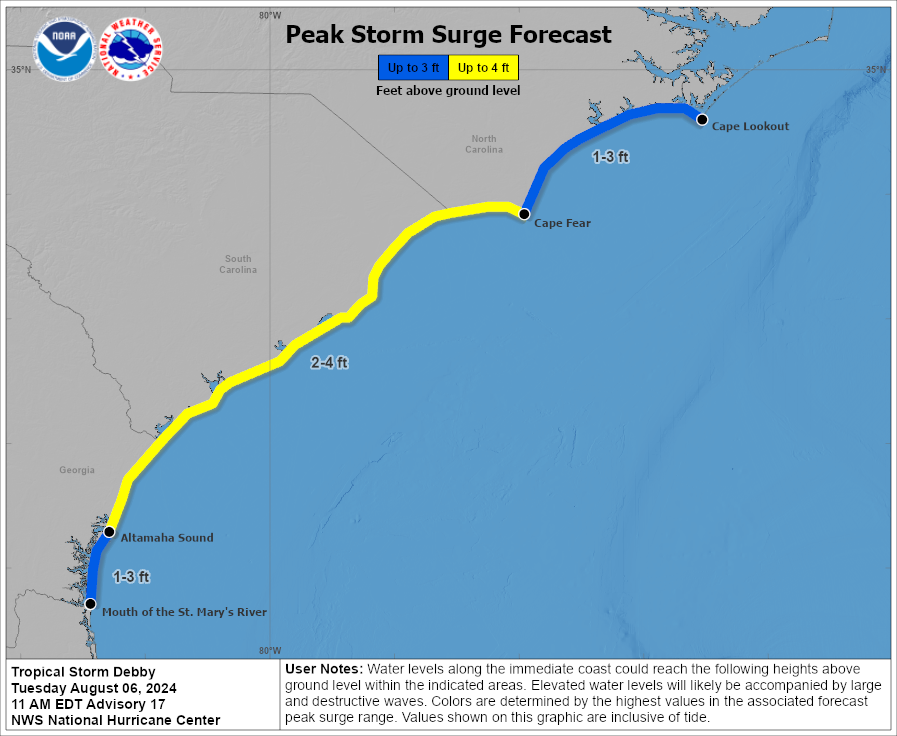
Tropical storm force winds extend out about 185 miles from the center. This also means Debby will have a bit widespread storm surge potential as it makes final approach tonight.
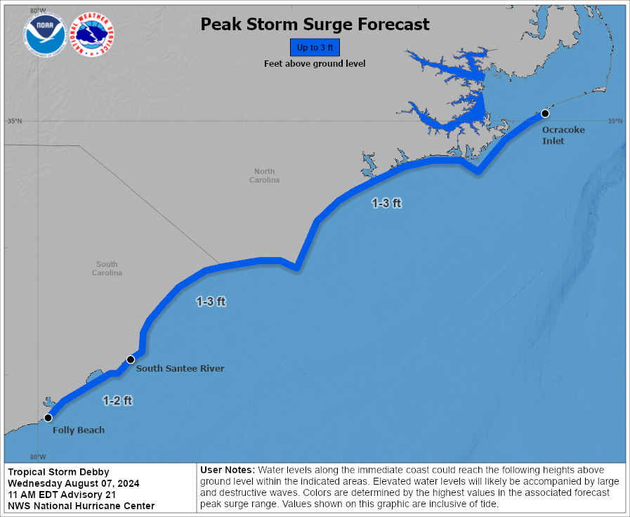
A 1 to 3 foot surge is expected between Folly Beach, SC and the Outer Banks as Debby maneuvers north today and tonight. (NOAA NHC)
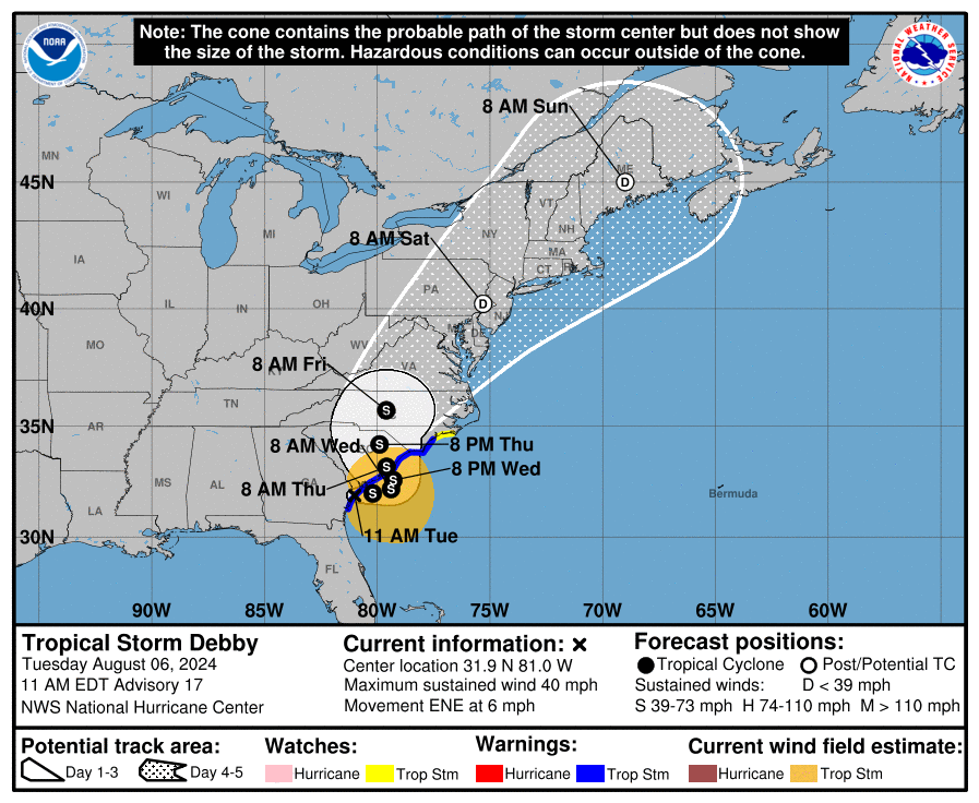
Certainly not the worst surge we’ve ever seen here, but spatially it will cover a wide area. From here, Debby will continue generally north and eventually northeast, accelerating and transitioning into an extratropical storm as it moves out of the Southeast.
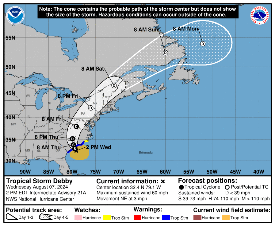
Debby’s track takes it up the Appalachians and into Quebec and Labrador through the weekend. (NOAA NHC)
Debby will track through North Carolina tomorrow, into Virginia early Friday, and across Pennsylvania and New York Friday afternoon and evening, into Canada this weekend.
Today’s concerns
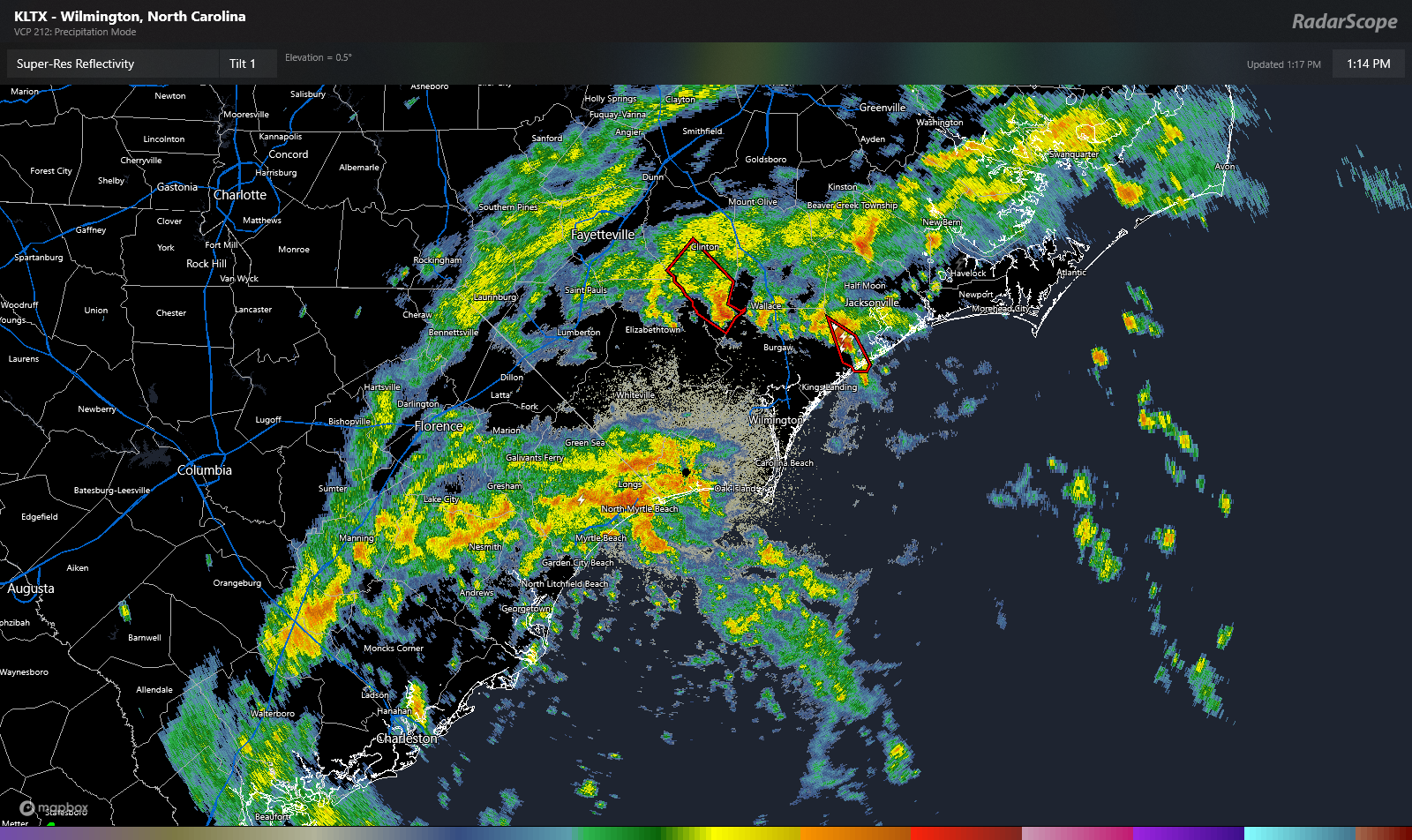
Heavy rain is ongoing again in South Carolina this afternoon. In addition, a couple tornado warnings are in effect in North Carolina as I write this.
Heavy rain is occurring in eastern South Carolina and portions of North Carolina. In addition, some storms are capable of producing tornadoes. (RadarScope)
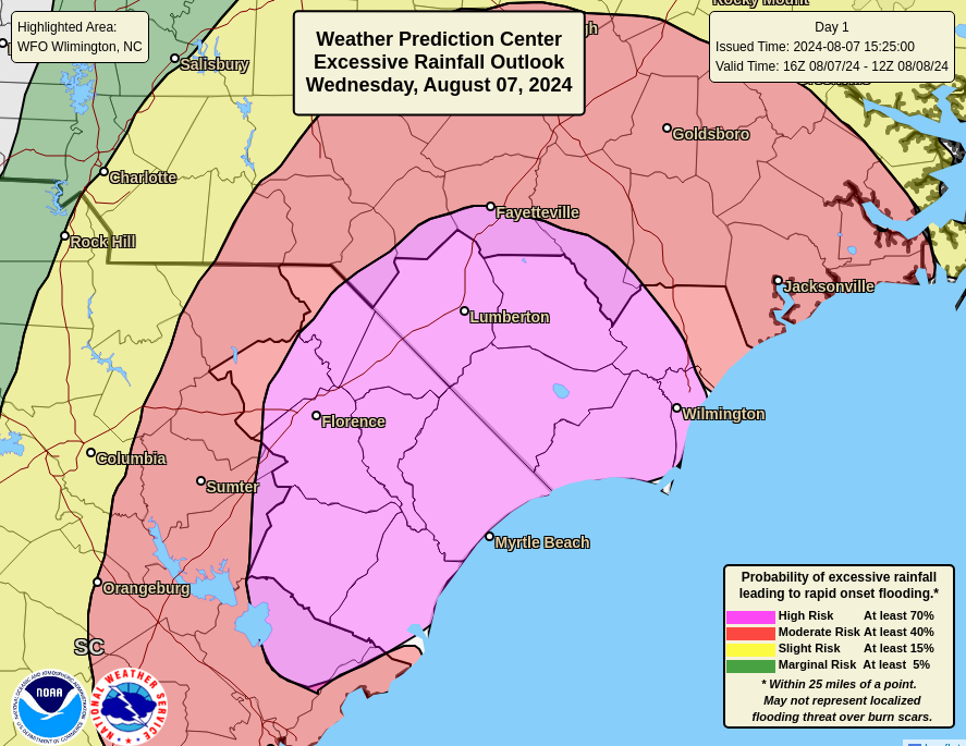
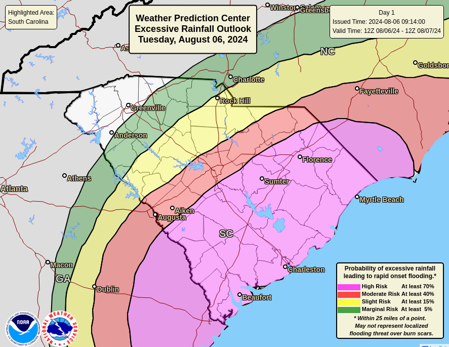
A high risk, level 4/4 of excessive rainfall is in place for much of southeastern North Carolina and northeastern South Carolina today. Some of the rain coming ashore now near North Myrtle Beach is quite heavy, and we’ll probably see flooding begin not too long from now in these areas.
A high risk of flooding exists today for portions of the Carolinas, including Lumberton, Wilmington, Myrtle Beach, and Florence, which also includes portions of I-95. (NOAA WPC)
Debby will only slowly come ashore today and tonight, so this rain isn’t going to move a whole ton. Hence why we see the flooding risks beginning to increase now.
Thursday’s concerns
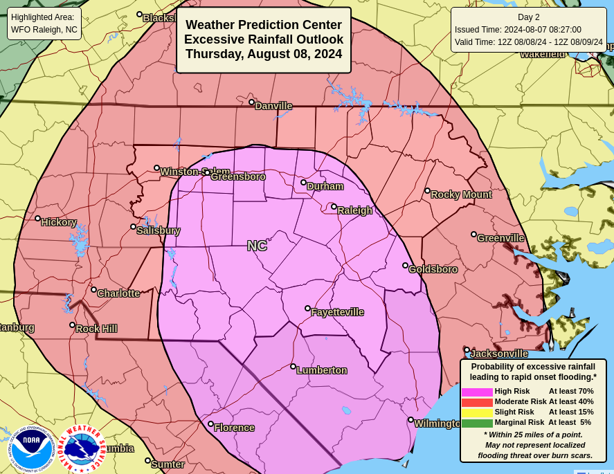
Debby will make an effort to get to the North Carolina border north of Florence tomorrow. This means that rain is only going to gradually expand northward. But that said, we will likely see a high risk again emerge for considerable flash flooding up into central and eastern North Carolina, including Fayetteville, RDU, and parts of the Piedmont.
The high risk (level 4/4) of flash flooding lifts north later tomorrow, expanding to include Fayetteville, Raleigh-Durham, and portions of the Piedmont. (NOAA WPC)
We could easily see 3 to 6 inches of rain anywhere in this region. Higher amounts are possible as well. Rapid onset flash flooding is likely to take place, so limiting travel in this area, and possibly avoiding I-95 south of Rocky Mount isn’t a bad idea tomorrow. Conditions should improve Friday in much of this area.
Friday’s focus comes north
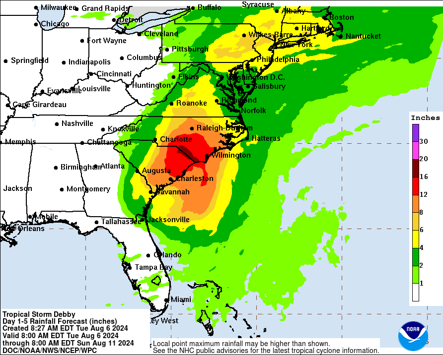
As Debby begins to accelerate north, getting absorbed into an upper atmospheric trough of low pressure Friday and Saturday, its heavy rain will also come northward. We expect to see a period of heavy rain as Debby’s core comes north along the eastern front of the Appalachians across Virginia, Central Pennsylvania, and Central New York. Some of these areas have seen very heavy rainfall recently, and it will take very little for flooding to unfold once more.
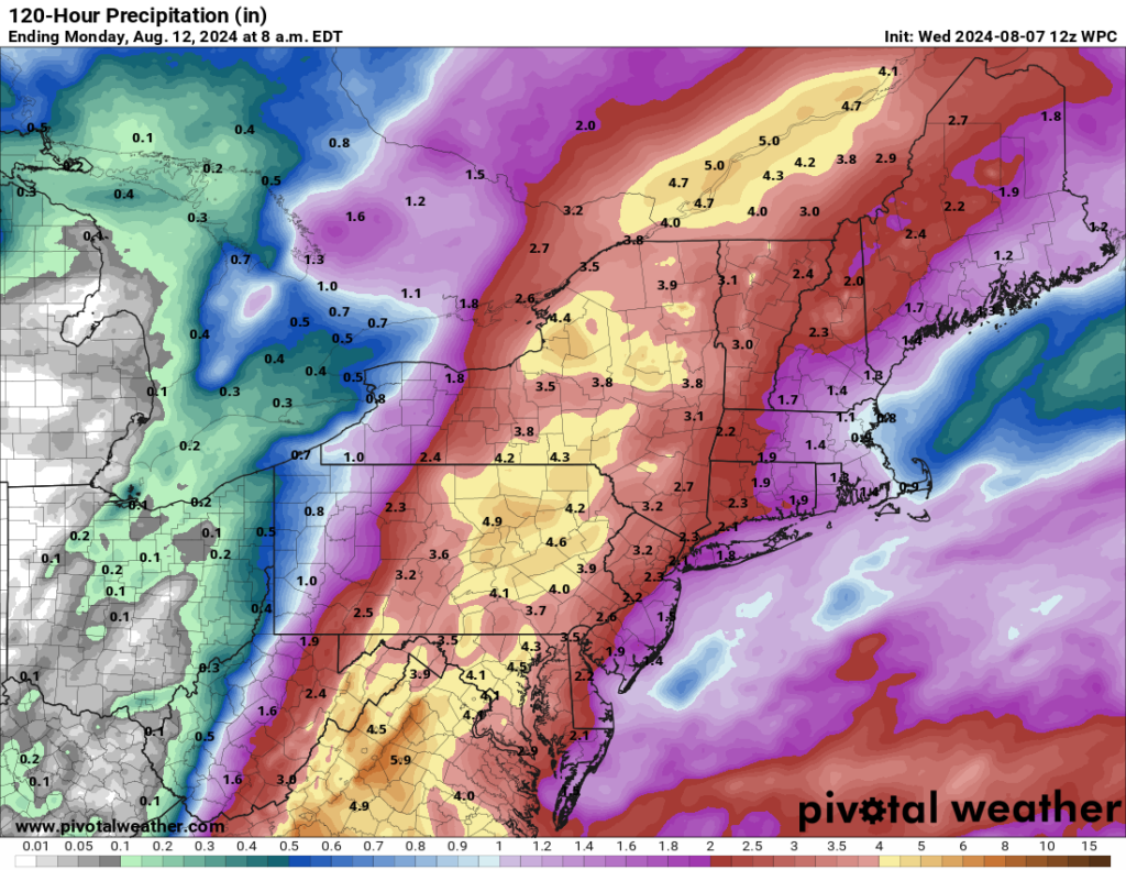
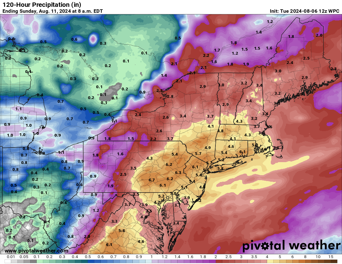
Total rainfall through Saturday and Sunday will be about 2 to 5 inches, with locally higher amounts possible between the Blue Ridge and Central New York into the St. Lawrence Valley of Quebec. (Pivotal Weather)
As of now, the moderate risk (level 3 of 4) for excessive rain does not include Philadelphia, New York City, or New Jersey, although some locally heavy rain is possible there too. It does include Harrisburg, Scranton, Syracuse, Utica, and Burlington, among other places. Portions of Vermont are extremely vulnerable to flooding right now, and any shift in Debby’s track could lead to a larger impact there.
From there, Debby heads into Canada, where heavy rain is likely across Quebec and Labrador. The heaviest rain should follow the St. Lawrence across Quebec. with perhaps even some locally heavy rain in Newfoundland’s Great Northern Peninsula. And then Debby will be gone. Goodbye.
Elsewhere in the tropics
Let’s get you caught up on some other issues in the tropics. First, the area in the Caribbean that we’ve been watching has seen a significant decline in development odds since yesterday. They’ve just been taken down to 0 percent, and as I noted yesterday, high pressure over Texas and the South should keep this wave firmly suppressed south of the Gulf. That’s that.
The Euro ensemble has multiple members showing some sort of signal for a system in the southwest Atlantic or northern Caribbean next week. (Weathernerds.org)
Looking farther east and farther out in time, we’re seeing a signal on European ensemble modeling for potentially two more waves to watch. The first one would arrive in the Lesser Antilles or nearby in about 5 or 6 days. No development is expected out of this one before then. Look for this to perhaps get added to the NHC big board tomorrow if model trends continue. Once in the eastern Caribbean or near the islands, it will sort of be at a crossroads. A weaker system or disorganized wave would probably get forced south and west back into the Caribbean and off to the west by strong high pressure over the South. A slightly better organized system would almost certainly feel the “pull” of the deep trough over New England.
Next week’s players as shown by the 06z European ensemble mean at 500 mb, 20,000 feet up. We’ll have a better idea on this in the coming days. (Tropical Tidbits)
It’s too early to speculate on what is more likely. The Euro ensemble certainly favors the “capture” scenario, but I’ve seen situations like this where the high is a little too strong and forces a southwest motion earlier, avoiding the capture. So I’m basically unsure about this wave. For now, it’s not a concern for anyone, but as is the case in August, check back in a day or two to see what’s changed.
Additional waves may develop off Africa heading into late month, but we don’t have any specific details as of yet.
Sponsors
I want to just highlight our brand new Sponsors page! I want to thank the businesses that have enthusiastically committed to supporting The Eyewall the rest of this hurricane season. I encourage you to check them out to see if their services support your interests or needs. Our readership extends from California to the Caribbean to Canada, but obviously we’re popular in Houston, our home base. If you want to sponsor The Eyewall and support our coverage around the Atlantic Basin, you can contact us from the sponsor page. We will work on a way for individuals to support the site in the future. Thanks as always for your support, and keep spreading the word.
Heavy rain from Debby will continue to impact South Carolina today and tomorrow.
Heavy rain expands northward after tomorrow with flash flooding likely into North Carolina and Virginia.
Combination of heavy rain today and Debby’s remnants may cause flash flooding in the Mid-Atlantic and New England by late week.
The 30% area in the Caribbean continues to look middling for awhile, and it is likely to stay somewhat suppressed to the south into next week.
Rainfall forecast for the next 5 days shows upwards of 10 to 15 inches or more of additional rain in the Carolinas, as well as a corridor of heavy rain in Pennsylvania, New Jersey, New York, and New England. (NOAA WPC)
Tropical Storm Debby’s heavy rain expands this week
Tropical Storm Debby is still a formal entity this morning, with 45 mph winds, and it is now drifting back offshore of Georgia, where it’s expected to meander through tomorrow night. It will then likely come back onshore Thursday and lift north and finally out on Friday. But before it does that, it will continue to dump copious amounts of rain on the Carolinas with an increasing signal for flooding to the north as well. Let’s walk day by day.
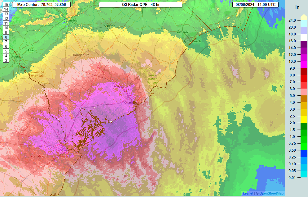
Radar estimated rainfall over South Carolina, showing maximum totals between Charleston and Savannah on the order of 8 to 14 inches or so. (NOAA MRMS)
Today
With Debby meandering offshore, expect heavy rain to basically continue in place. There will be rainfall rates of 2 to 4 inches an hour at times, mainly north of Hilton Head and south of Columbia. But, as 6 to 12 inches of rain has already fallen, flash flooding is underway, and it will continue.
A high risk of flash flooding (level 4/4) exists across eastern Georgia, much of southeastern South Carolina and southern North Carolina today. (NOAA WPC)
As Debby drifts a little farther offshore, the rain may become a little more scattered or intermittent, but it will continue to potentially flood areas through the day. Debby should not gain much intensity today as it meanders offshore, as it will be getting its bearings.
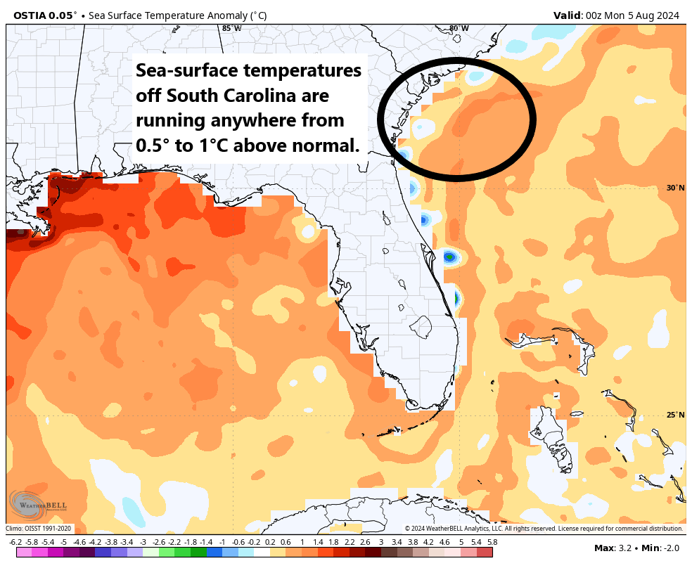
Debby will continue to meander offshore, but with generally low shear and warm water off the coast of South Carolina, it will likely begin to reorganize some. It could become a strong tropical storm again as it turns back northward toward the South Carolina coast later tomorrow.
Water temperatures off the South Carolina and Georgia coasts are running as much as 1°C above normal, favorable for Debby’s intensification. (Weather Bell)
On Wednesday, the flooding threat mostly exits Georgia and is confined to South Carolina and extreme southeastern North Carolina, including Wilmington, Myrtle Beach, and Charleston. Travel on I-95 may be a bit difficult as well through the Florence area, depending on exactly where the heaviest rainfall sets up. Another high risk is in effect in this area.
Thursday
Debby should move back inland across South Carolina on Thursday. Storm surge will again be a concern (as will high tides between now and Thursday).
Surge of 2 to 4 feet above ground level is possible along the South Carolina coast and nearby adjacent waters as Debby meanders offshore and comes back ashore Thursday. (NOAA NHC)
Surge of 2 to 4 feet will be possible along the South Carolina coast and possibly parts of Georgia and North Carolina as well with Debby moving around offshore and coming back onshore.
As Debby comes north a little more steadily Thursday, heavy rain will spread into North Carolina. While flooding risk will have mainly been confined to the extreme southeast corner of the state to this point, there will be a pretty significant expansion of heavy rain northward on Thursday that will engulf more of the state, including the Sandhills, the Raleigh-Durham area, and portions of the Piedmont in a moderate or high risk of excessive rain and flash flooding.
A high risk (level 4/4) of excessive rain and flooding will expand deep into North Carolina on Thursday, with moderate (level 3/4) risk surrounding it over a wide area even into Virginia. (NOAA WPC)
Most of the rain on Thursday will front run Debby, as the south side of its circulation will probably have lesser rain and more scattered showers. As the center gets across North Carolina late Thursday and Thursday night, we’ll see conditions slowly improve. But some serious flash flooding is a concern in both rural and urban areas of the eastern half of the state.
Friday-Saturday
Debby will continue to come northward on Friday, likely tracking across Virginia and eventually being absorbed by a trough digging into the Midwest and Great Lakes. What does this mean? Debby will become extratropical here, meaning it’ll transition from a tropical storm or depression into low pressure, a process that is meteorologically noteworthy but will have little impact on impacts seen. Heavy ran will spread across Virginia and into portions of Maryland, Pennsylvania, and New York here. These areas are expecting heavy rainfall today as well, so with soils saturated, additional rainfall from Debby will exacerbate issues.
Rainfall between today’s storms and Debby’s remnants will add up to over 6 inches in spots between Pennsylvania, New Jersey, New York, and New England. (Pivotal Weather)
Flash flooding is likely on Friday or Saturday as Debby’s exit strategy unfolds. This may include Philly, New York, and Boston.
From here, Debby’s remnants will accelerate out, likely bringing some locally heavy rain and gusty winds to portions of Quebec and Atlantic Canada. And we can finally close the book on Debby.
Rest of the tropics
We continue to watch a tropical wave with a 30 percent chance of development per the National Hurricane Center. This doesn’t look like much today, but as it comes west it may develop.
A tropical wave with minimal thunderstorm activity in the southern Caribbean has about a 30 percent chance to develop as it comes west. High pressure over Texas and the South will likely keep it tracking toward Mexico. (Weathernerds.org)
I will say that some of the more aggressive modeling with this wave has backed off considerably in the last 24 hours, and at this point there is minimal operational or ensemble model support for any development. 30 percent seems reasonable, if not a little aggressive right now. Regardless, high pressure over Texas and South will probably keep this wave fairly suppressed and tracking toward Mexico next week. We’ll continue to watch.
Behind this, there are no other areas of interest highlighted by the NHC, but the next wave emerging off Africa is showing some signs of developing in modeling. We have about a week to watch before anything happens with that one, so we won’t over-speculate. All in all, as we get into the mid-August period, things look average. That’s good. I’m sure it won’t last, but we’ll hopefully have a couple days after Debby to exhale and regain our bearings.