In brief: As the Atlantic presses the mute button, the Pacific is churning storms out like a factory. The one of most concern is Hurricane Lowell, which could directly or indirectly threaten Hawaii early next week.
First of all, a special thanks to all our new subscribers and followers over the last few days with Edouard looming. Hopefully you find The Eyewall to be a useful resource for your weather consumption diet.
Edouard latest
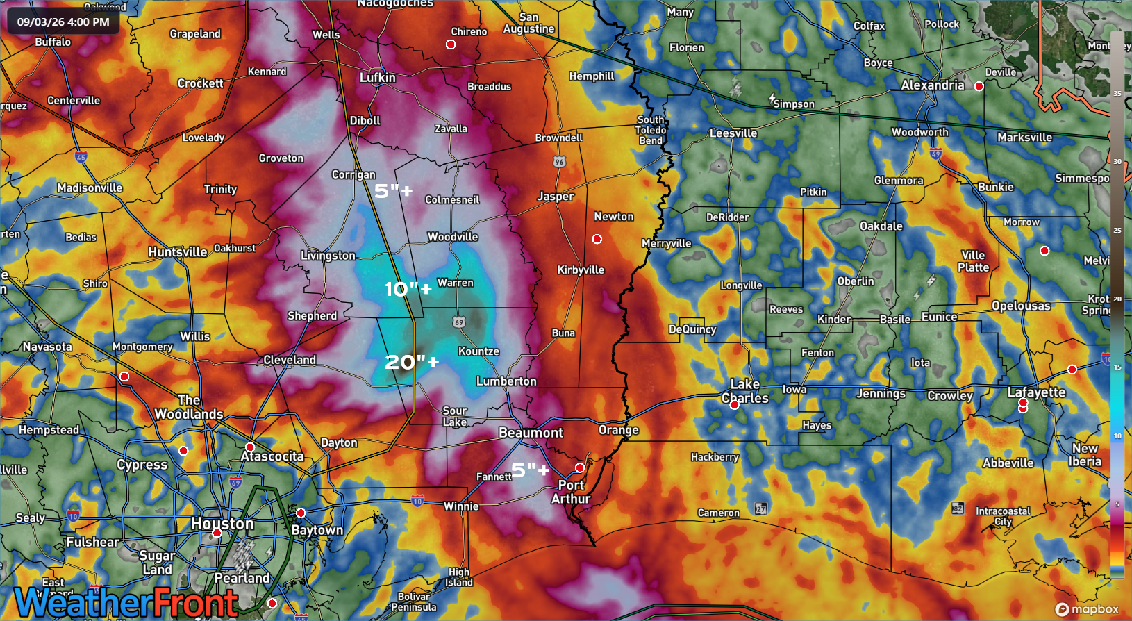
Rain totals are finalizing in parts of Texas worst impacted by Edouard. A gauge along Little Pine Island Bayou in Hardin County measured over 24″ of rain from Edouard. A gauge on the Hardin/Tyler County line reported almost 18″, and another one just north of there near Warren, TX reported just under 17 inches.
Gauge corrected rainfall estimates over East Texas from Edouard. (Weather Front)
A CoCoRaHS gauge near Kountze picked up over 13 inches as well. This was a truly classic inland flooding event. Given the impact region’s low population density, we’ve seen scattered reports of rescues and damage. I’m sure more details will reveal themselves in the coming days.
Atlantic tropics
It does not get any quieter than this in early September.
The next two weeks of tropical activity per the Google Deep Mind ensemble. (Weathernerds.org)
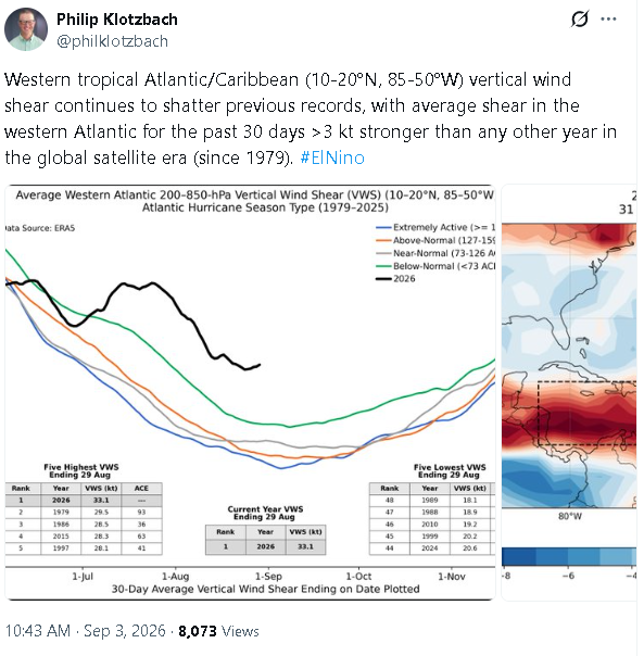
Google’s ensemble model shows next to nothing out there. The same can be said for most other modeling I’ve seen, from the Euro to the AIFS to even the usually more active GEFS. Subseasonal forecast data from the European Centre seems to imply activity will remain below 50% of normal over the next 3 to 4 weeks. This is par for the course in a near-record strong El Niño. As Dr. Philip Klotzbach, noted on X earlier today, wind shear is at record levels by a wide margin right now. Edouard showed the narrow way we can circumvent that. Dolly showed how the Atlantic will probably govern itself the rest of the season. If anything is going to occur through October, it will almost certainly do so close to home and at the last minute.
The Eastern Pacific has been very active and will likely remain very active over the next 4 to 6 weeks, as is typical in El Niño, further aided by abnormally warm water all the way up to Baja and California. We have Marie and Karina out there now. But we also have Lowell, and Lowell is a problem.
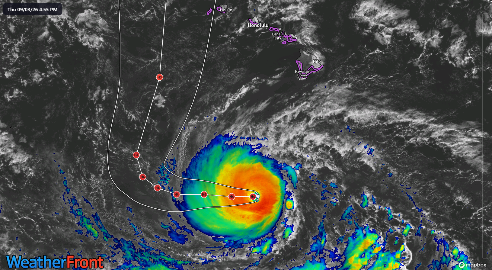
Hurricane Lowell about 500 miles south of Hawaii on Thursday evening (WeatherFront)
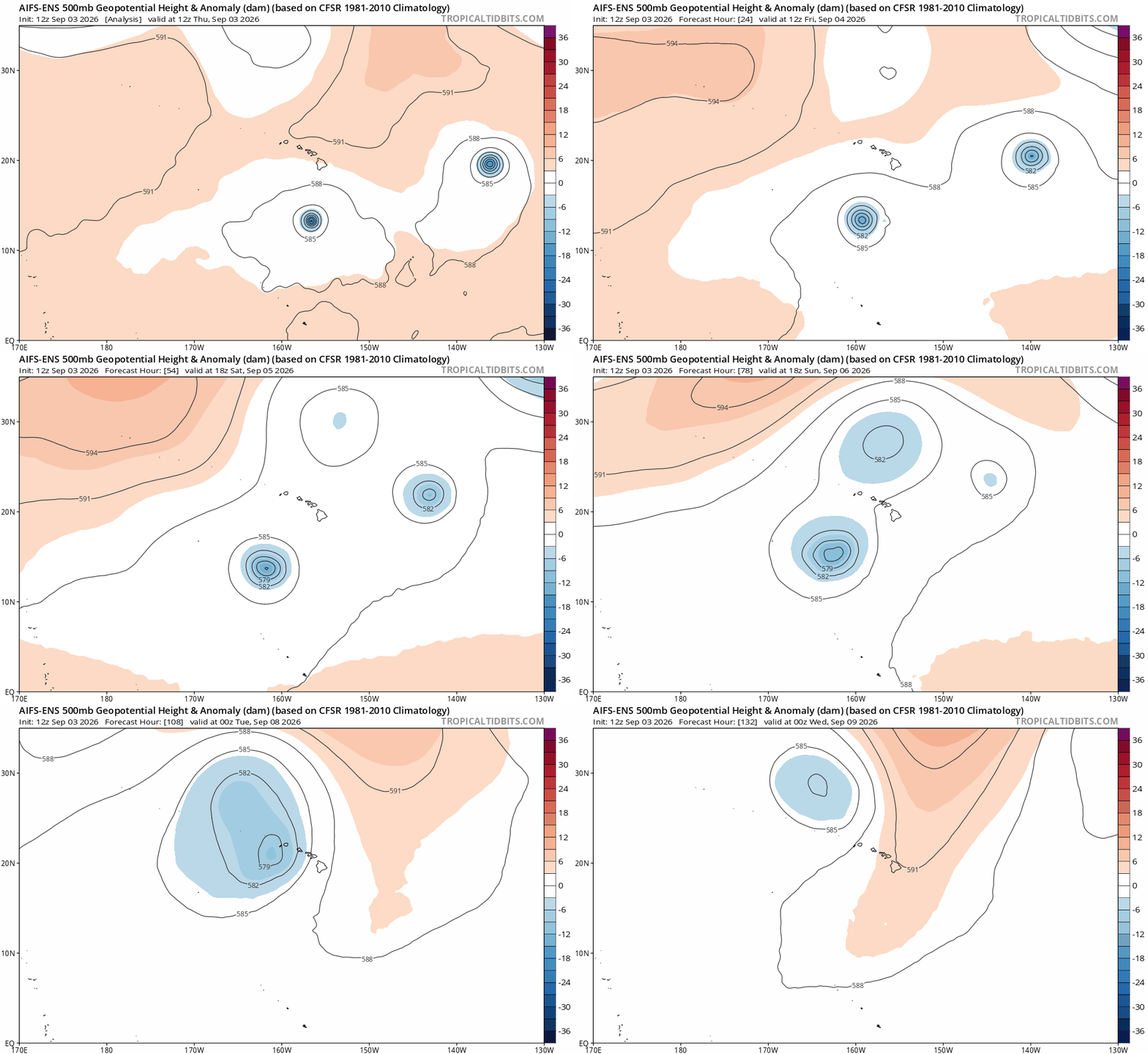
Lowell is currently a powerful hurricane with 140 mph maximum sustained winds. While it is fighting some shear, it’s core looks healthy, and the conditions over the next couple days should support a strong intensity, with occasional fluctuations. The general steeringpattern for Lowell is straightforward: It continues west before the ridge controlling that movement gets eroded, which causes Lowell to have an “exit” route north. There are two elements of this that make Lowell’s forecast decidedly not straightforward. First, at what point will the erosion of the ridge occur by an upper low east of Hawaii? That will determine when Lowell slows and turns. Second, how exactly will that upper low dictate Lowell’s trajectory?
Karina on the right, Lowell at the left, and an upper low materializing that will try to capture Lowell and force it closer to Hawaii. (Tropical Tidbits)
For a time, Lowell may actually turn north and then north northeast, tracking it back toward Hawaiian longitudes. The more aggressively that occurs, the more likely a direct impact will be felt on more of the islands. This is a “capture” scenario we see often in the Atlantic with storms coming out of the Gulf or curving back out to sea in the Atlantic. It’s all about trajectory and timing, and with upper lows, let alone upper lows in the middle of the ocean, it is notoriously challenging to predict specifics.
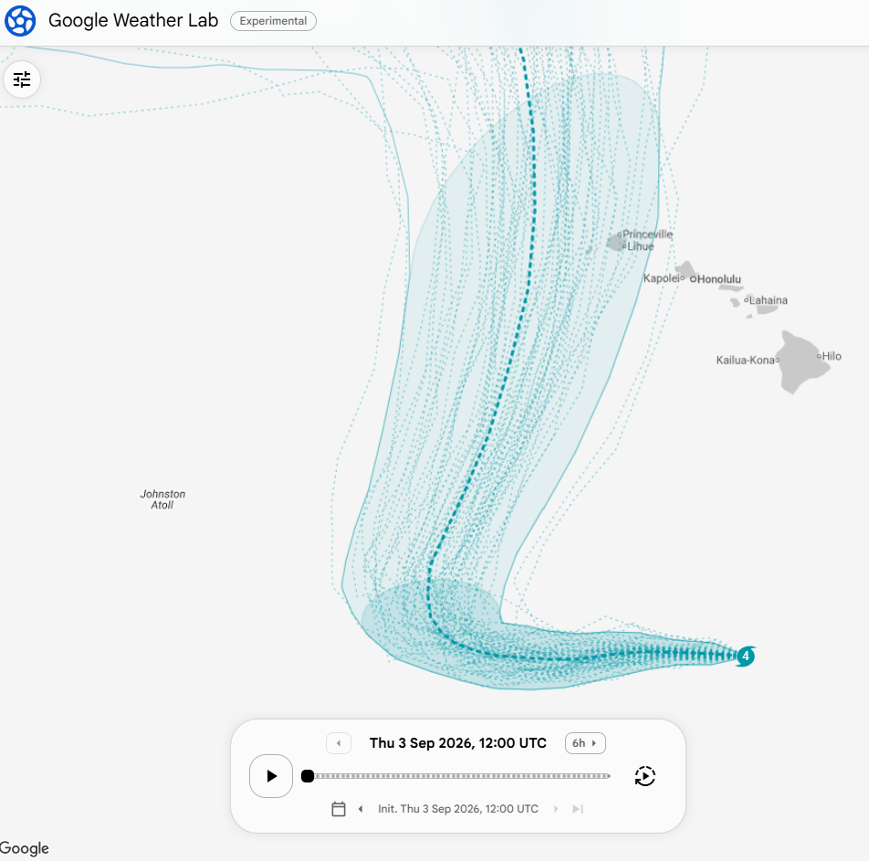
Google WeatherNext 3 ensemble forecast for Hurricane Lowell (their newest operational model) showing a very, very, very close call for the western Hawaiian Islands. (Google)
You can see how this manifests in the ensemble spread among Google Deep Mind ensemble members. (This is off their WeatherNext 3 model that they just released to the masses today) Many are west of Hawaii, but several are very close to the westernmost islands. The farther east within that ensemble envelope Lowell tracks, the greater the impact to the Hawaiian Islands.
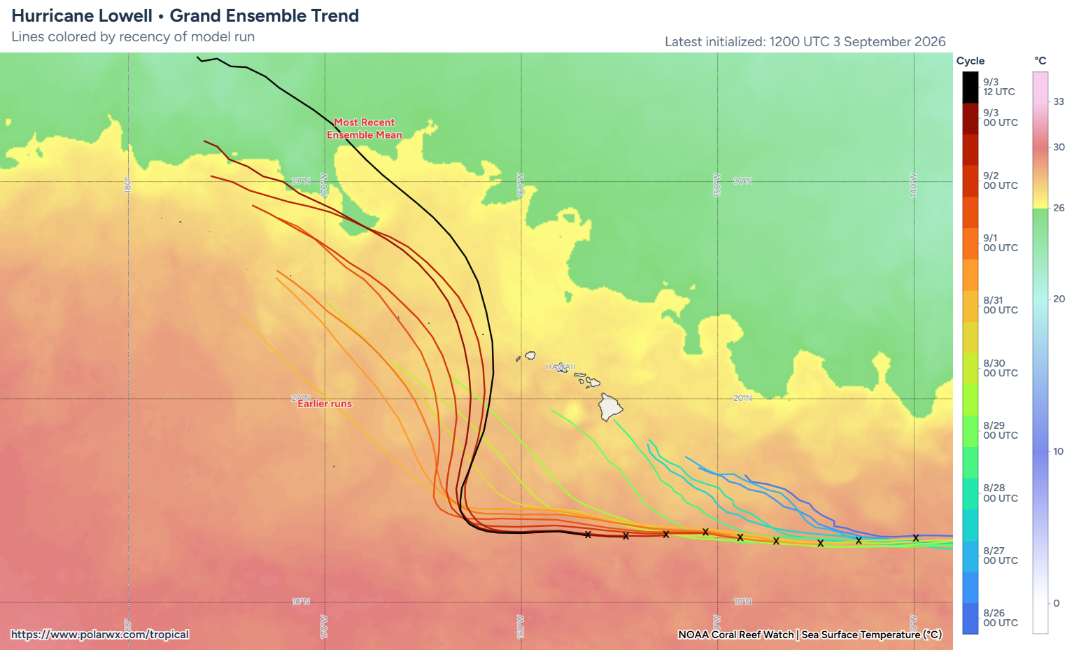
Ensemble mean trends over the last few days have been creeping back much closer to Hawaii. (Polarwx.com)
And indeed, we’ve seen other modeling besides Google trend closer and closer to Hawaii the last couple days. The most recent ensemble mean is the closest pass yet.
We know that these impacts, whatever they may be, will likely begin on Monday or early Tuesday sometime. Folks in Hawaii should continue monitoring this forecast closely, as Lowell will likely maintain a good bit of its intensity once up near Hawaii, possibly still even close to major hurricane intensity. It’s going to be an uncomfortable couple days watching this.
In brief: This post takes a look at how one specific tool we use performed during Edouard’s flooding overnight. The tool is slated to be decommissioned next month, but I want to highlight it as a success and one that perhaps should not be retired quite yet.
Overnight, terrible flooding played out in parts of East Texas. I hate the phrase “thankfully it occurred in a rural area,” because that devalues rural residents. You can read about what’s going on in that region here, but while it’s great that the toll wasn’t worse, it still impacted a number of folks northeast of Houston. Some will need support getting back to normal. Keep them in your thoughts.
Heavy rain is ongoing just north of those areas this evening, and overnight the focus should shift northward toward Lufkin or Palestine or Tyler, where modeling is indicating, again, the potential for double digit rainfall in some spots.
RRFS model run of forecast rainfall tonight in Texas, showing the risk of torrential, flooding rains near Lufkin, Tyler, or Palestine. (WeatherFront)
Here’s hoping the dry soils there help mitigate problems a bit.
Reality check: I’ve seen some conjecture by some prominent voices on social media about “brown ocean effect” possibly contributing to Edouard’s intense rains overnight. I highly doubt that was the case with Edouard, though we’ll see what researchers find. What is more likely the case is that Edouard did what many inland post-landfalling tropical storms do over Texas. There is what we call a “diurnal” cadence to thunderstorm development in these storms. You can go in depth on the mechanics of how this all works through various Google searches (I’ve yet to find a great link to share), but in a nutshell: Hurricanes and tropical storms are heat engines. They act to transfer heat energy from the tropics to the higher latitudes. So at night, as the upper atmosphere cools off, you are left with this gigantic (or in Edouard’s case, somewhat horizontally challenged) storm and a growing degree of atmospheric instability, thanks in part to the growing temperature gradient between the cooling atmosphere and warmer core storm. Add in a wide open gate to a hotter than normal Gulf of Mexico, and you have the recipe for torrential, efficient rain producers. This was one reason why we were quite bulled up about rain risk last night.
The brown ocean effect implies that a storm is literally gaining energy because the ground is so saturated that it’s acting like a marsh or bay. This was absolutely not the case in East Texas last night in my opinion. Edouard was not actually intensifying. It was producing better organized tropical rains at a very efficient rate, similar to previous storms like Imelda, Harvey, or Allison. Well-documented physical processes are cooler than cool-sounding terminology.
We’re retiring the HREF model. Should we be?
I want to dig into the weeds a bit here. Earlier this year, NOAA announced that a slew of modeling would be discontinued, ostensibly because it requires a good deal of computational power that is rapidly becoming outdated and inefficient. On its merits, it’s a reasonable decision. And it is one we have known was coming. One of the modeling products slated for decommissioning is the HREF, or high resolution ensemble forecast system. It’s to be replaced by a newer version, the rapid refresh (RRFS) ensemble forecast system, or REFS. All of this is scheduled to occur on October 6th.
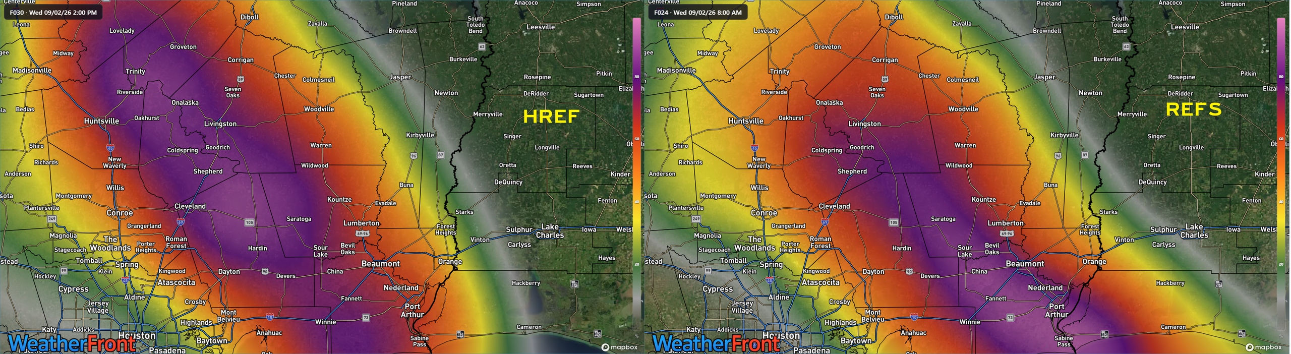
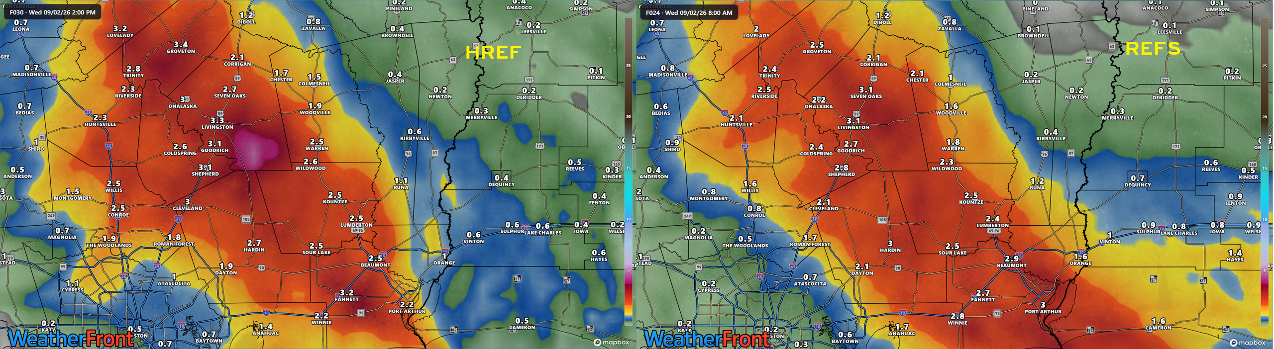
I raise this point for a very specific reason. First of all, let’s take a look at what both the older HREF and newer REFS showed for probability of 5″ or more of rainfall with Edouard from 8 AM Tuesday through 8 AM Wednesday.
Click to enlarge (WeatherFront)
Both indicated a good probability of 5″ or more somewhere in the corridor between Trinity, TX and Sabine Pass. Fair enough. Let’s see what their ensemble mean rainfall forecasts were for the same period at the same initialization time.
Click to enlarge (WeatherFront)
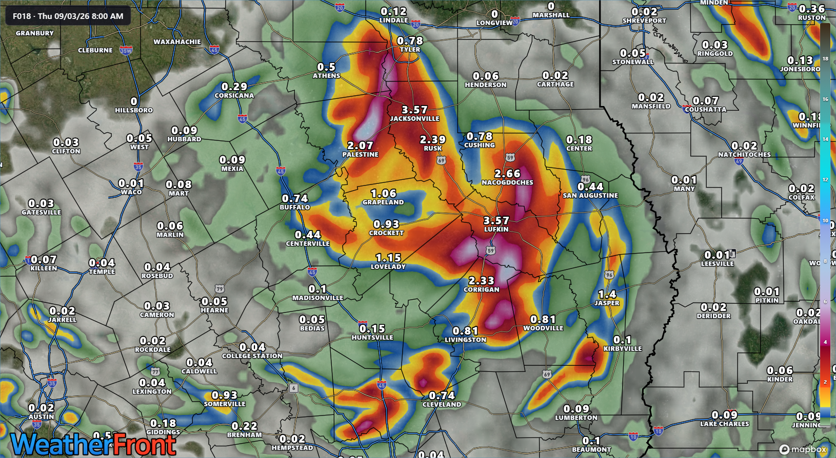
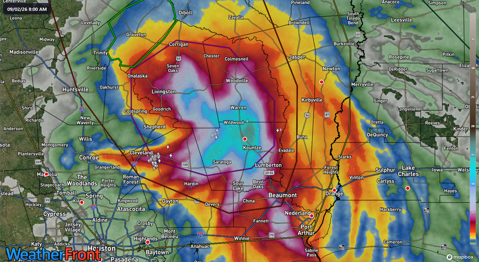
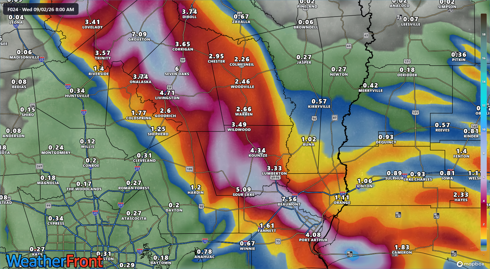
In this instance, the HREF actually outperformed the REFS in terms of indicating, explicitly 5″+ of rain in the forecast in a small area near Lake Livingston. This actually ended up being not too far off the bullseye of the final tally as of 8 AM.
24 hour rainfall gauge corrected estimates from MRMS as of 8 AM Wednesday. (WeatherFront)
Now, if you used the actual operational RRFS at 12z (same initialization time as the models above) for the rain risk overnight, you saw a much more aggresssive story.
RRFS model forecast rainfall from 8 AM Tuesday’s run. (WeatherFront)
This indicated at least the risk of double digit total rainfall, perhaps up to 10 inches.
Within the HREF there is a product called “probability matched mean” and “local probability matched mean.” It is defined as this:
Conceptually, PMM (probability-matched mean) is a variation of the ensemble mean with the original ensemble amplitude restored. At each grid point, the ensemble mean value is replaced with a value from the full distribution of individual member forecasts whose rank matches the point’s rank within the ensemble mean distribution.
LPMM (localized PMM) is a new technique from Clark (2017, WAF) wherein the PMM calculation is restricted to grid points inside some radius of influence, preventing precipitation in geographically distant areas from influencing the local value. On this site, we use r=110 km.
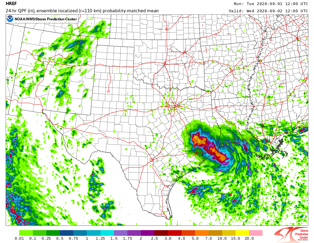
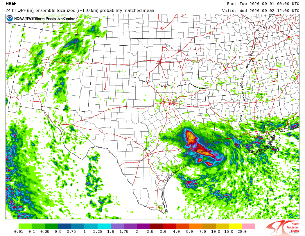
I recognize for most of our readers that’s a whooooooole lotta jargon. In brief: It’s another tool that we as meteorologists use to gauge how much rain may fall in a given location. Or what the maximum potential is in a situation where it could be realized, such as, say, in a landfalling tropical storm. Here’s what that LPMM product showed us yesterday after the same 12z run we have above.
24 hour localized probability matched mean rainfall from HREF on Tuesday morning. (NOAA)
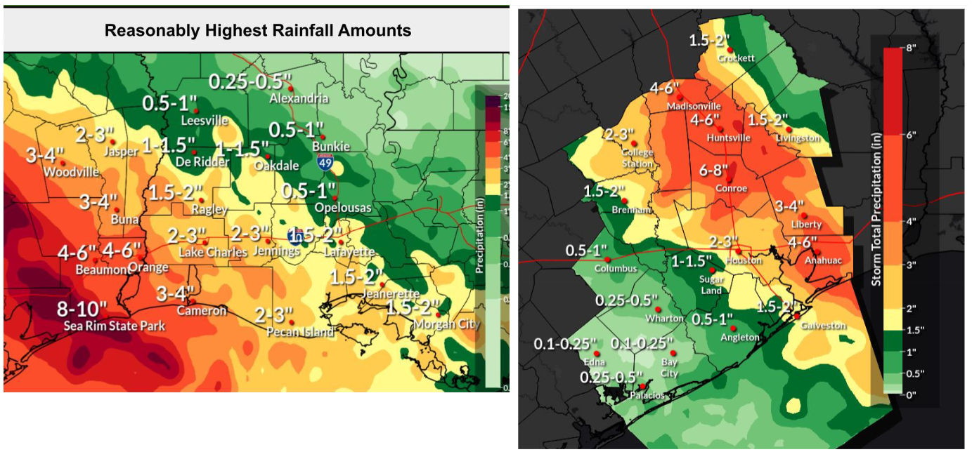
In that particular product, it shows that there was potential for 10 to 15 inches of rain or even more in the 24 hours ending this morning. Now compare that to the actualized rainfall map above. It did somewhat poorly on placement. But if you were a meteorologist looking at the forecast on Tuesday morning for the rainfall after Edouard made landfall, you had a really important data point from the LPMM. Not to throw anyone under the bus here, but no one’s rainfall forecast was particularly great overnight for East Texas. Here were some of the NWS forecast rainfall graphics from yesterday morning I cobbled together from social media.
A reasonably highest rainfall forecast at left and a total rainfall forecast at right from NWS. (NWS)
The signal in the LPMM product was consistent enough though. Even on Monday night’s run it showed potential for 10-15″ of rain near or just southeast of Lake Livingston.
Monday evening’s HREF run LPMM ending Wednesday morning. (NOAA SPC)
Astute readers might have noticed I included this in yesterday morning’s post.
This is somewhat speculative on my part, but the remnant center of Edouard should be in the Brazos Valley tonight, near Huntsville or Madisonville. We sometimes see the centers of these things try to pop up more numerous thunderstorms than forecast during the diurnal peak in convection overnight (the propensity for tropical systems to peak their thunderstorm activity in the overnight hours). There could be a localized flooding threat somewhere up near Huntsville, Madisonville, or Centerville overnight, so just be aware of that.
And this in yesterday evening’s post.
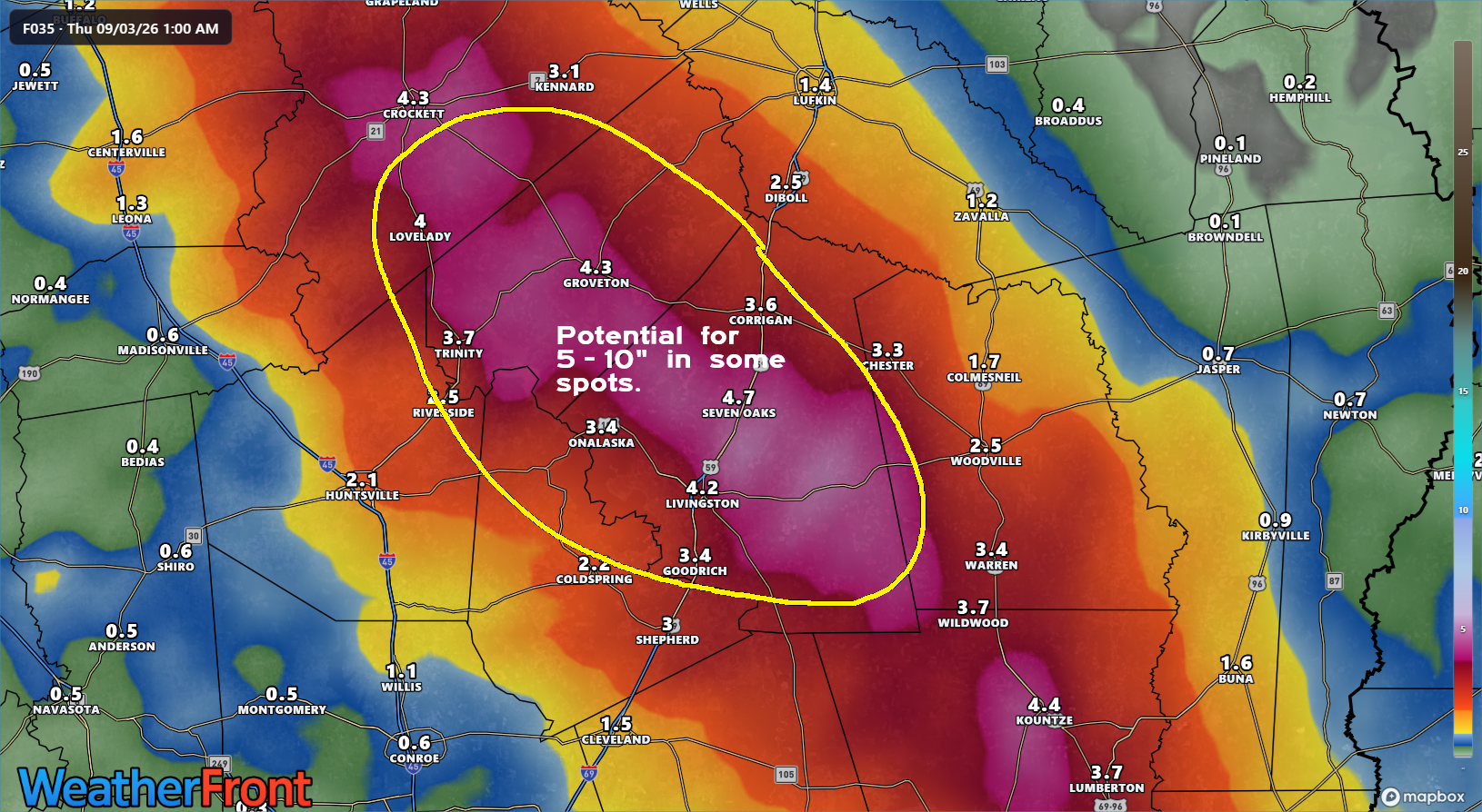
As we go through tonight, the heaviest rain will fall near the track of Edouard inland. That is currently expected to work toward Lake Livingston in southeast Texas and perhaps toward the Huntsville area. Depending on the exact track, we could see a period of torrential rainfall after midnight near the center of Edouard or just to the southeast. I mentioned this earlier this morning as a possibility, but I am more concerned about this now after looking at the latest model data. This does not include the Houston metro. This should theoretically line up somewhere between Crockett, Huntsville, and Lake Livingston. This is the area I am most concerned about with regard to flash flooding tonight. Some of the higher resolution modeling we use shows potential for 5 to 10 inches or even more of rain in that area, particularly near Lake Livingston.
Let me be clear here that I’m not self-aggrandizing. But one of the tools I always, always, always look at ahead of heavy rain events is the HREF’s PMM or LPMM product. In conjunction with other forecast data, it allows me and other forecasters to better understand the risk environment we’re in.
Progress is progress, and NOAA has been clear that these tools are heading for decommissioning. However, I know I am not the only forecaster that uses these tools regularly.
Many years ago, when I was early in my career, we had a model called the NGM model. It stood for Nested Grid Model. Several of us, the author here included, joked that NGM stood for “No Good Model.” It had exceeded the end of its useful life by the early 2000s when the ETA and AVN models were upgraded to the NAM and GFS models. Those models were superior in almost every way, and most forecasters saw that, so the NGM was retired. And yes, a few people pushed back. Change is inevitable. But I’m not sure the forecast community has gotten the reassurance it needs from NOAA.
There’s a case for reducing output because it’s inefficient. I worry that the momentum and pressure to forge forward comes at the expense of targeted forecast situations where that output excels (like last night). I’m sure I’ll hear from folks at NOAA about this that it’s been tested and is good and the NWS forecasters have been using it regularly. And that’s great. I have heard many good things about what’s coming. But remember, as non-government operational forecasters, as users every day of this stuff to communicate to the public, we are the ones who need to see the products regularly before we can just adopt them and take everyone at their word. Statistical analyses are important, but they do not factor in day-to-day operational utility or forecaster comfort of using a tool. Certain models may be “better” or “good,” but that does not instantly deem them useful.
The phrase in statistics is that “all models are wrong. Some models are useful.” And when you get a useful model, even if it’s a little outdated, you should probably hang on to it for as long as you can.
In brief: Edouard made landfall as a moderate to strong tropical storm this afternoon, with wind gusts of 60 to 70 mph in the Port Arthur and Sabine Pass areas. Tonight, the focus shifts to heavy rain, and there is a localized significant flooding risk outside the Houston Metro area near Lake Livingston and perhaps parts of the Piney Woods. We explain.
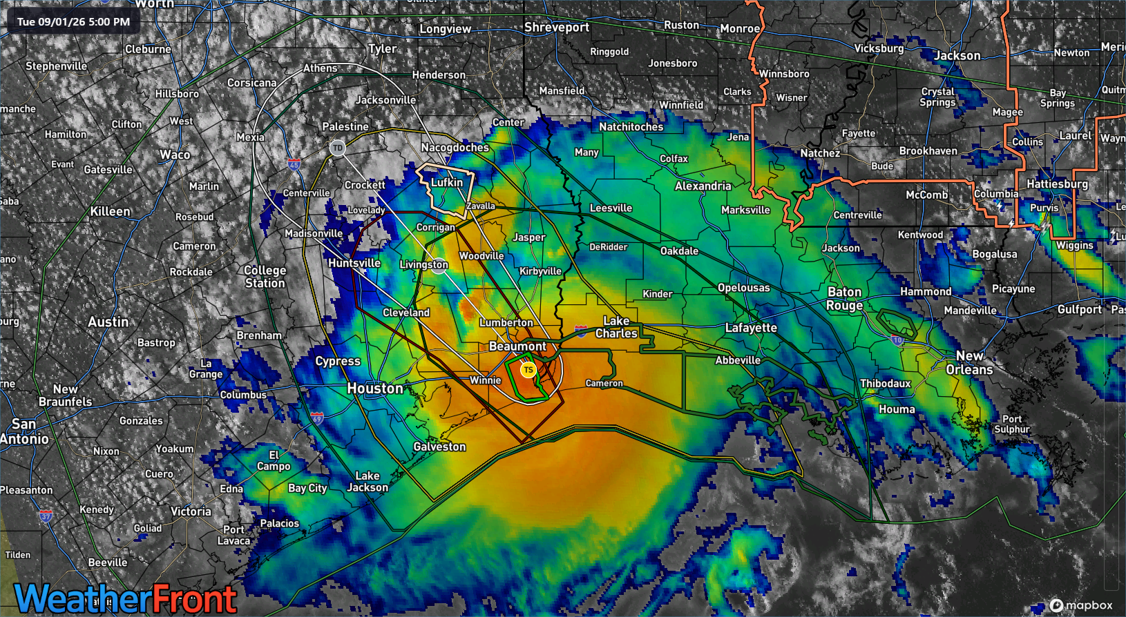
Tropical Storm Edouard gets a tip of the cap this evening. While it did not quite go to the maximum intensity risk we discussed last evening (as a possibility, not a likelihood), it did strengthen into a respectable tropical storm, outdoing all but Bertha this season in terms of accumulated cyclone energy.
Edouard moving inland over Texas this evening around 4 PM CT. (WeatherFront)
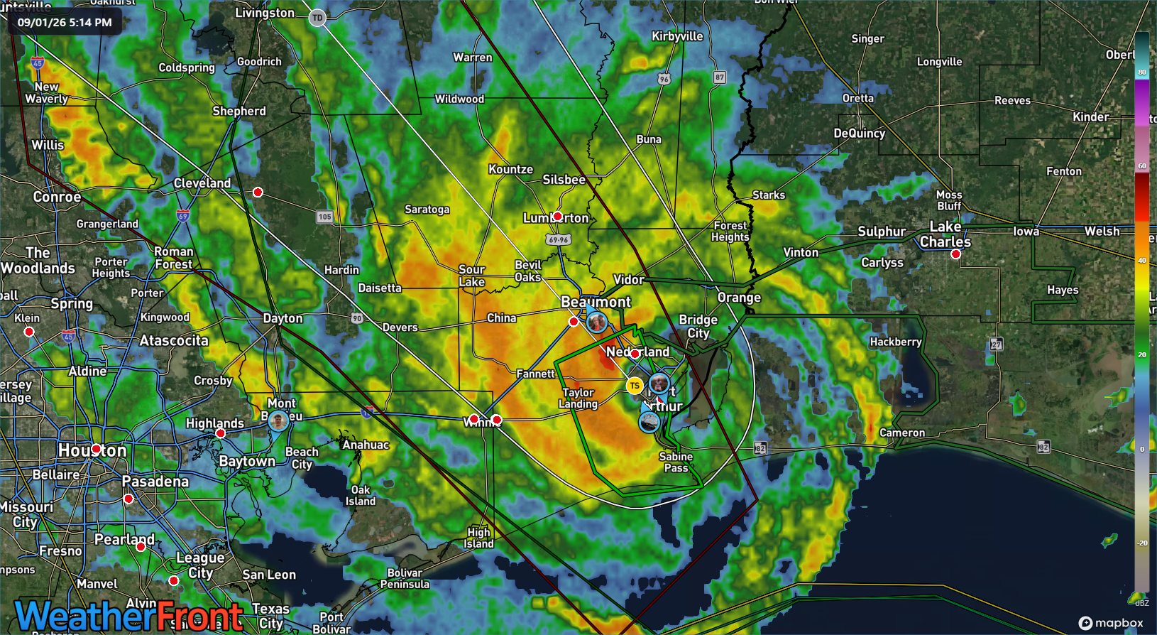
Heavy rain is moving inland with Edouard. Totals have been as high as almost 3.5 inches just west of Port Arthur. Heavy rains continue.
A radar capture just after 4 PM CT on Tuesday. (WeatherFront)
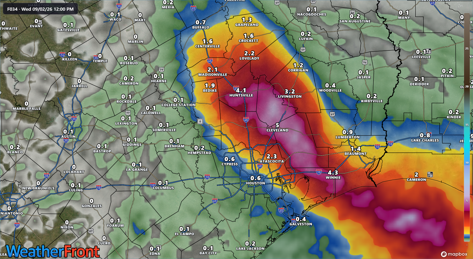
As we go through tonight, the heaviest rain will fall near the track of Edouard inland. That is currently expected to work toward Lake Livingston in southeast Texas and perhaps toward the Huntsville area. Depending on the exact track, we could see a period of torrential rainfall after midnight near the center of Edouard or just to the southeast. I mentioned this earlier this morning as a possibility, but I am more concerned about this now after looking at the latest model data. This does *not* include the Houston metro. This should theoretically line up somewhere between Crockett, Huntsville, and Lake Livingston. This is the area I am most concerned about with regard to flash flooding tonight. Some of the higher resolution modeling we use shows potential for 5 to 10 inches or even more of rain in that area, particularly near Lake Livingston.
Rain totals tonight should be highest well north of Houston and east of I-45, near Lake Livingston, TX. (WeatherFront)
I would encourage any of our readers in that area around Lake Livingston to take special care to pay attention to things overnight as the rain evolves.
After that, while Edouard is done, there may continue to be sporadic bouts of locally heavy rain in interior Texas, particularly between I-35 and I-45 east of Waco tomorrow and perhaps west of Waco on Thursday. Keep an eye on flooding chances in localized areas there. We know all too well how Texas geography sometimes manages with decaying tropical systems.
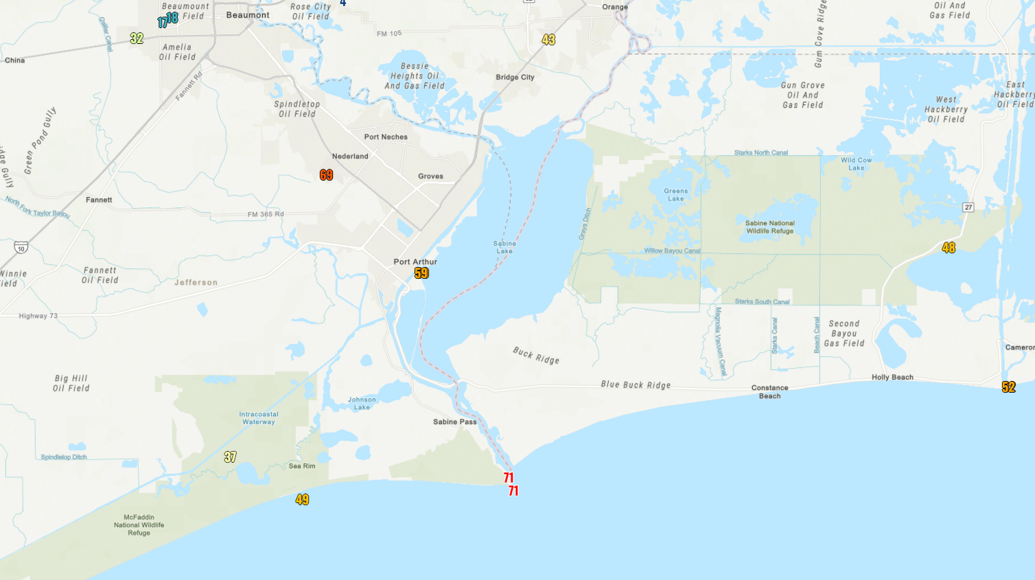
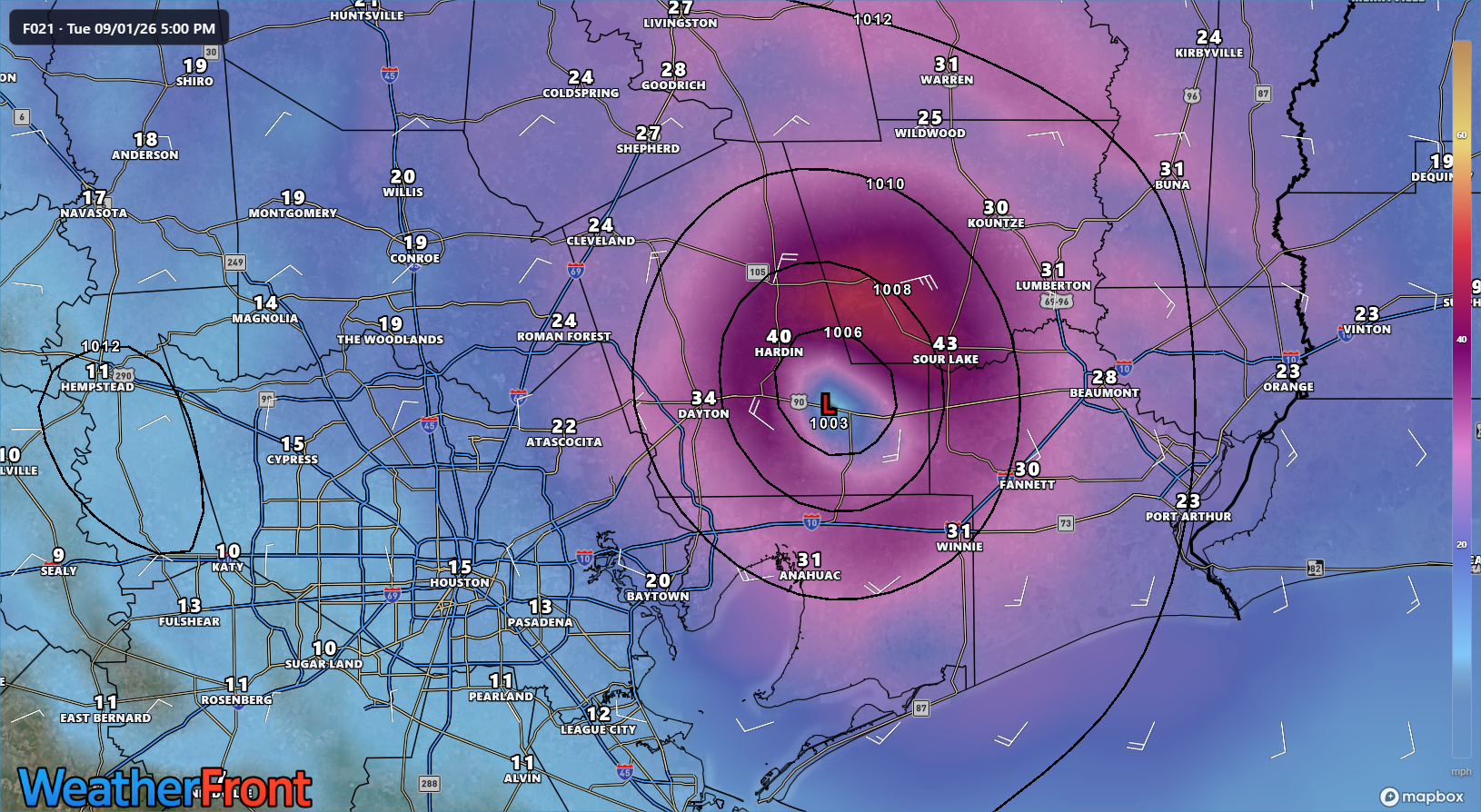
In terms of wind, Edouard will rapidly weaken over the next few hours. Current wind gusts stand around 35 to 45 mph in most spots, but the airport in Nederland just recently gusted to 69 mph and Sabine Pass is still seeing some 50 to 60 mph gusts right on the water. Maximum wind gusts were as high as 71 mph at Sabine Pass, near 60 mph in Port Arthur, and just over 50 mph at Calcasieu Pass.
Maximum wind gusts reported so far from Edouard at official stations. Other reports will also trickle in over time. (NOAA)
We’ll continue to watch the progress of Edouard inland. The good news? There’s absolutely nothing else on the Atlantic side of the tropics to worry about over the next 7 to 10 days. We’ll take that at peak season.
In brief: Tropical Storm Edouard has about 8 to 12 hours left over water to intensify, and it will make an effort to do so. But it will run out of time later, bringing some gusty winds, surge, and heavy rain to parts of Louisiana and Texas. We discuss the situation in detail below.
The good news is that Edouard managed to make it through the night without intensifying much. In fact, maximum sustained winds this morning remain around 40 mph. The less good news is that “under the hood,” Edouard seems poised to try and make a go at intensifying a bit before it makes landfall in about 8 to 12 hours from this writing. Basically, Edouard has what it needs to try and intensify quickly up to landfall but whether its able to put all those things together is an open question and the difference between a sloppy 40 mph tropical storm making landfall and a compact 60 to 70 mph tropical storm making landfall.
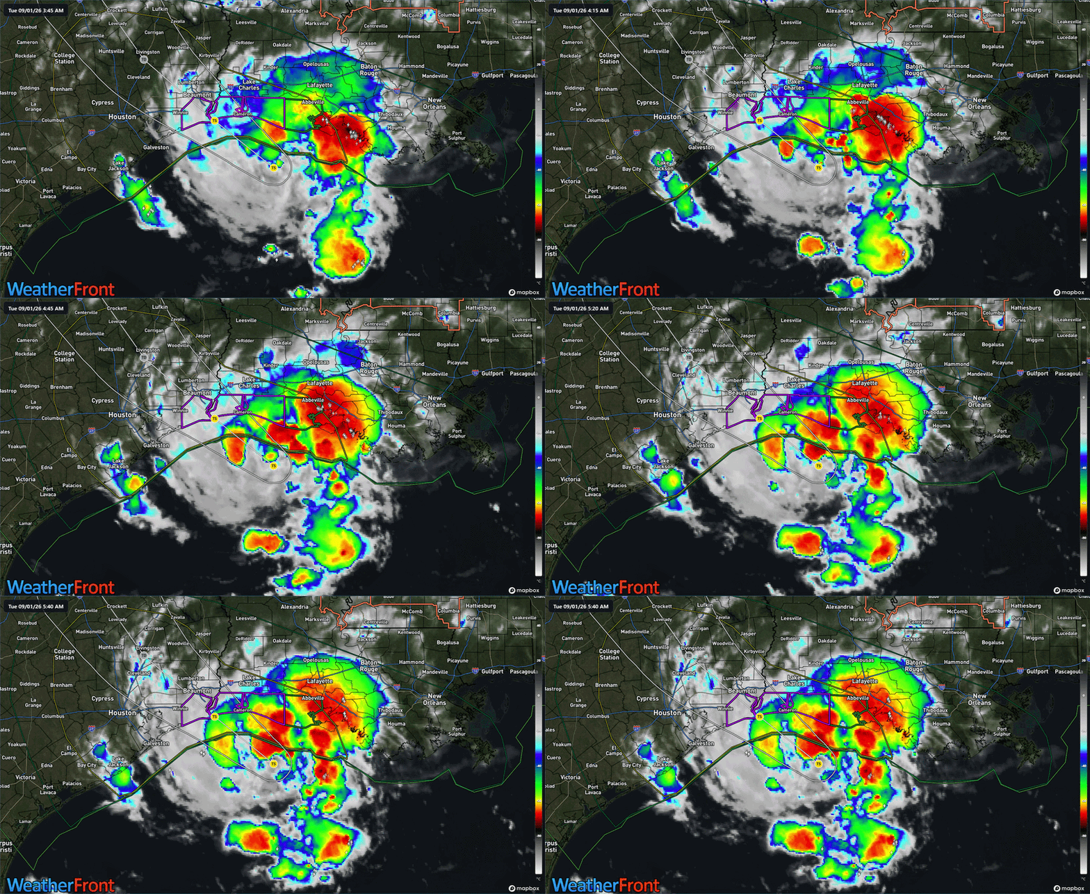
Edouard is trying to wrap some stronger thunderstorms near the center, usually a sign the storm is trying to intensify. (WeatherFront)
The NHC has taken that latter scenario and applied it to Edouard’s forecast, bringing ashore a 65 mph tropical storm near Sabine Pass later today. The environment around Edouard, other than proximity to land is as optimal as you really need for intensification. I saw a post on social media yesterday from someone that said essentially, “I suspect we’re going to see a lot of ‘good thing this didn’t have 24 more hours over water’ posts tomorrow.” I forget who posted it, but it seems spot on. The biggest limiting factor to Edouard today will be that it has less than 12 more hours over water.
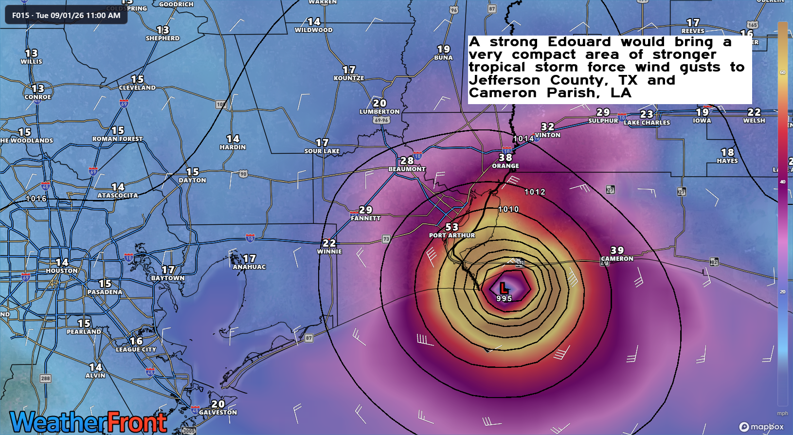
In terms of impacts, Edouard will make landfall sometime this afternoon, likely within 10 miles or so of Sabine Pass, TX. Recall yesterday that we said Edouard’s wind field was likely to be compact when it began intensifying, no more than 30 miles or so across. The current wind radius on Edouard is 25 miles from the center. This means that any wind impacts from Edouard will be very isolated to near where the center comes ashore. The best chance of wind gusts officially reaching tropical storm intensity will be between Cameron, LA and just west of Sabine Pass, perhaps to High Island.
HAFS-B model forecast of Edouard’s wind gusts near landfall, showing a tight, compact area of stronger tropical storm force wind gusts isolated to within 20 to 30 miles of the center. (WeatherFront)
Edouard is going to weaken quickly once inland, and by the time it reaches I-10, it will probably barely be able to hold together tropical storm force wind gusts.
Edouard’s winds should be mostly below tropical storm intensity when it gets to Liberty, Hardin, and Chambers Counties east of Houston. (WeatherFront)
Some residual gusts to tropical storm strength are possible east of Houston, across Liberty, northern Chambers, or Hardin Counties but that would be about it. It seems highly unlikely that Houston itself will see tropical storm conditions at any point.
Obviously, the rain will be another story. It continues to appear that any real flash flooding risk is east of Houston today and tonight. Locally heavy rain may occur across Liberty, Chambers, Hardin, and Jefferson Counties in Southeast Texas and in Calcasieu and Cameron Parishes in Louisiana.
Forecast rain from the REFS ensemble through midday Wednesday. Some areas will see less than shown here. (WeatherFront)
Rain totals are taken from the REFS ensemble system above, and they may be a bit aggressive east of Houston. But you get the idea: 3 to 6 inches of rain in a narrow corridor between Houston and Beaumont.
This is somewhat speculative on my part, but the remnant center of Edouard should be in the Brazos Valley tonight, near Huntsville or Madisonville. We sometimes see the centers of these things try to pop up more numerous thunderstorms than forecast during the diurnal peak in convection overnight (the propensity for tropical systems to peak their thunderstorm activity in the overnight hours). There could be a localized flooding threat somewhere up near Huntsville, Madisonville, or Centerville overnight, so just be aware of that. A flood watch is posted over a wide area of Texas today.
The good news is that a lot of places are rather dry right now, so the rain should be soaked up in a lot of cases. Obviously, you never want too much too fast. But the hope is that this will limit serious flooding.
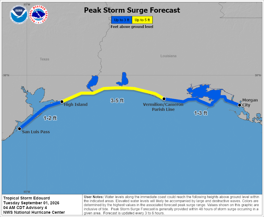
Last point here, storm surge flooding should impact travel on Gulf Beach Highway in Louisiana through the day today, with up to 5 feet of surge possible near and east of where Edouard comes ashore.
Peak surge forecast potential from Edouard. (NOAA NHC)