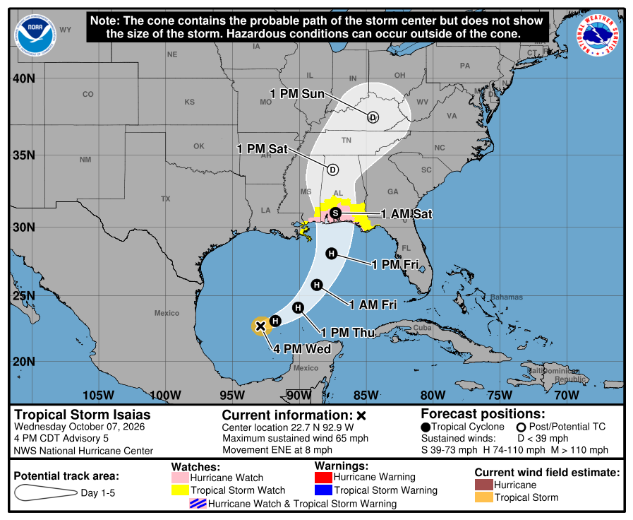
In brief: Tropical Storm Isaias is slowly strengthening in the Gulf this evening, as it likely becomes a hurricane by tomorrow. It will turn north and race toward the Gulf Coast between Biloxi and the Florida Big Bend on Friday night, making landfall, likely as a hurricane with wind and storm surge, as heavy rain and severe weather spread across the Southeast this weekend.
Tropical Storm Isaias has spent the day getting organized, and just around sunset this evening, it may look actually the worst it has all day. It’s pretty evident that wind shear is impacting the western flank of the storm right now. Satellite estimates are that it’s battling about 20 kts of shear near the center and substantially more than that on its northwest flank, hence the rather ragged appearance of the storm this evening.
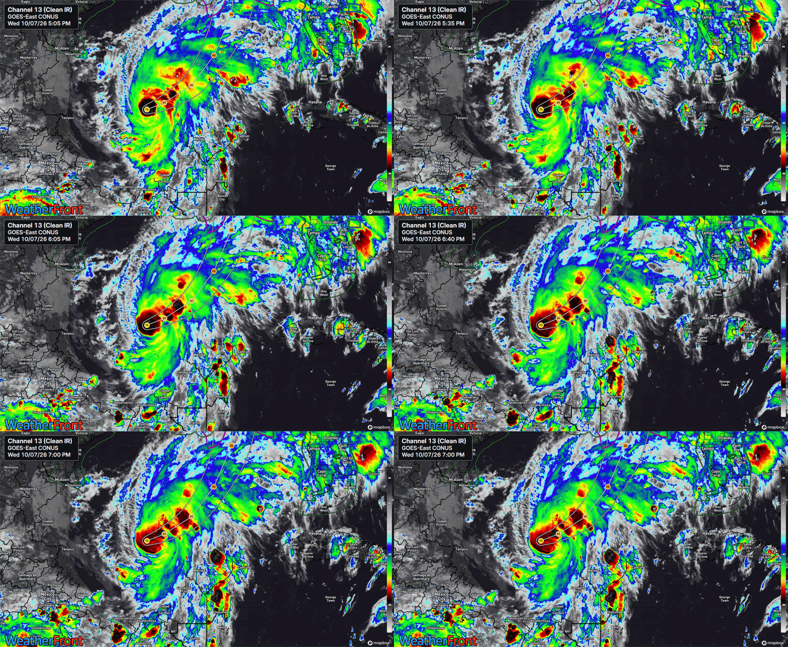
Isaias is moving east northeast around 8 mph, away from the shear axis over the western Gulf, which means it should gradually find a little less shear over the next 12 to 24 hours. That’s when we should see Isaias reach its prime and strengthen into a formidable hurricane. Shear will once again begin to hammer Isaias on Friday morning, and this should be when we see it begin to weaken a bit.
First key point: While Isaias is going to fluctuate in intensity over the next 48 to 72 hours, the Gulf Coast, especially east of Mississippi and west of the Big Bend in Florida should be preparing for a hurricane, possibly a borderline major hurricane landfall.
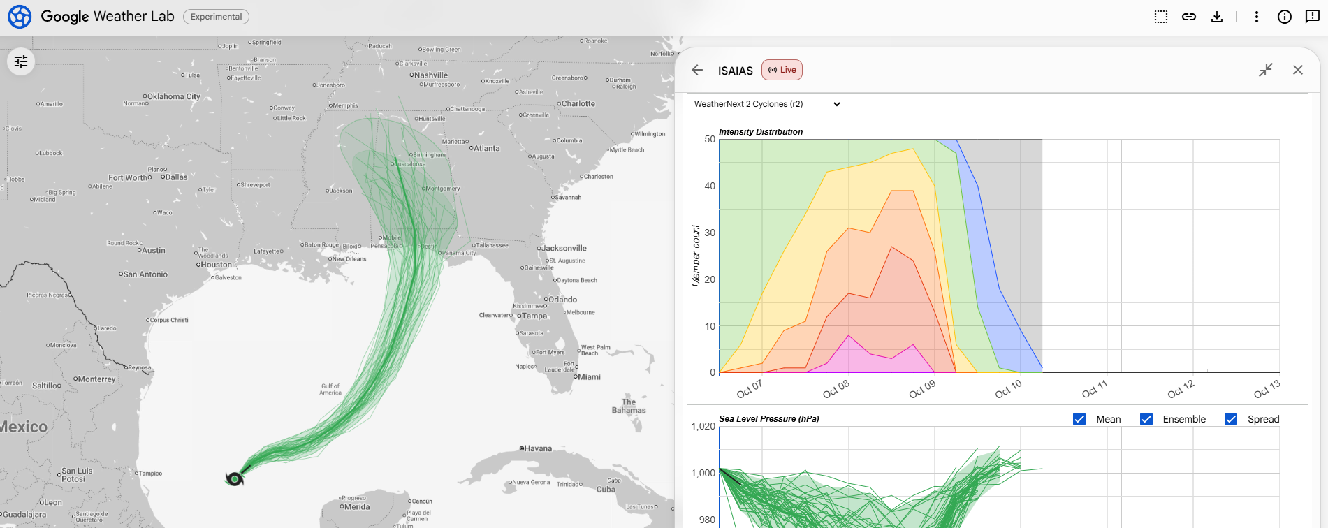
In terms of how strong it gets, Google’s 1,000 member ensemble is still showing about a 75 percent chance of Isaias strengthening into a major hurricane at peak. Google’s operational ensemble is around 50 to 60 percent odds of peaking as a major hurricane. The tropical models lag Google by a bit, though even most of those still peak Isaias as a category 1 or 2 storm. Either way, this is sort of like debating the difference between calling it aluminum or aluminium. There are scientific and classification considerations here, but for all intents and purposes for the eastern and central Gulf Coast it seems it’s going to peak as a pretty decent hurricane.
So what about landfall intensity? As noted, on Friday, we’ll see Isaias likely get hammered by wind shear that worsens throughout the day as it approaches landfall in the evening. If you notice the chart below, the same intensity chart as above, I have us flagging the intensity dispersion right at or immediately before landfall.
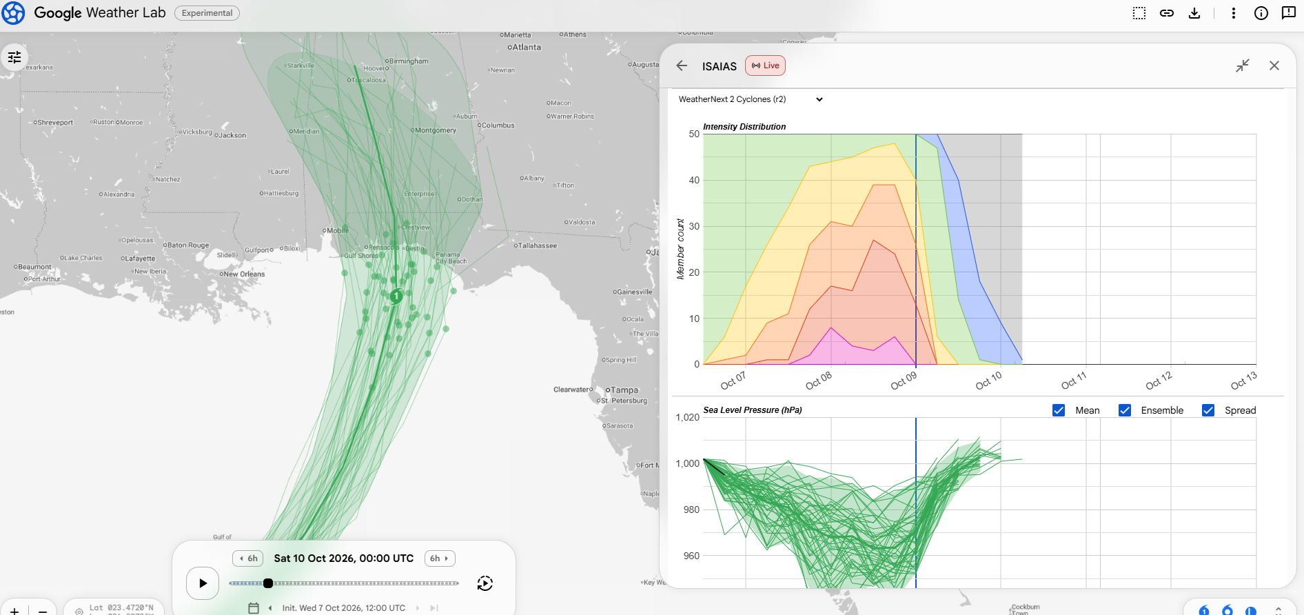
Indeed, at or around landfall, about 25 percent of members maintain Isaias as a major hurricane and roughly half have it as a Cat 1 or tropical storm. But here’s the thing about that. Weird things often happen in October in the Gulf. This is why I would encourage folks to prepare for the worst case scenario, not hope for the best case outcome. We’re good at hurricane forecasting today, but we’re far from perfect. And there’s about a 1 in 4 chance that Isaias will come in near its peak intensity, assuming it can get to Cat 2 or 3. It should also be noted that Isaias will be booking it north at 15 to 18 mph in all likelihood, which may limit how much time there is for Isaias to substantially weaken before hitting land.
Key point 2: In this instance, given the accelerated timeline and fast forward motion of Isaias at landfall, it’s wise to prepare for the higher end outcome risk on the Florida Panhandle and in Alabama.
Where will Isaias make landfall? The tropical models like Biloxi, MS through Destin, FL as the landfall window. Google’s model seems to like Mobile Bay through Panama City, FL. This matters to a point because the worst impacts of Isaias are going to be exaggeratedly on the eastern flank of the storm. But basically, anyone east of Biloxi is on notice, with a special notice for folks between Mobile and Destin, FL right now. This could further change between now and tomorrow. Average track errors at this point in the system’s life cycle are still fairly meaningful.
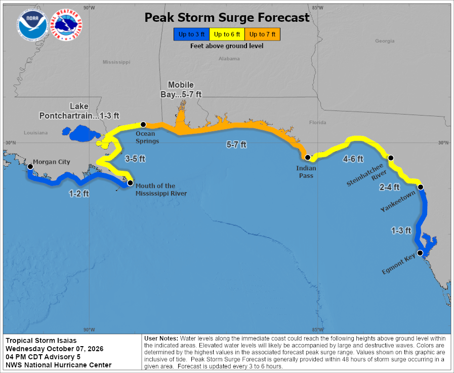
This also matters for storm surge, as the surge near and east of where the center makes landfall will see surge levels of 5 to 7 feet above ground level, formidable. Keep in mind, we have lost more people to surge and flooding over the years than any other element of a hurricane. Take it seriously.
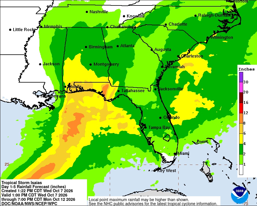
The good news is that the rainfall threat seems to be a little lower overall with this storm. Some areas east of where the center comes in could still see 8 to 10 inches of rain, but it appears that the flash flooding threat and inland extent of flooding, while a noteworthy element of this storm is not likely to a catastrophic one.
One thing I am becoming a little more concerned about with respect to Isaias is severe weather. As Isaias moves northward into the Tennessee Valley, it will spread rain and thunderstorms over a wide area of the Southeast. There are multiple areas within Isaias’s overall circulation that may be primed for some severe weather. Shear is going to be outrageously high. While wind shear is detrimental to a tropical system’s organization, it is an element that can enhance isolated to scattered severe thunderstorms by creating more potential for rotating thunderstorms.
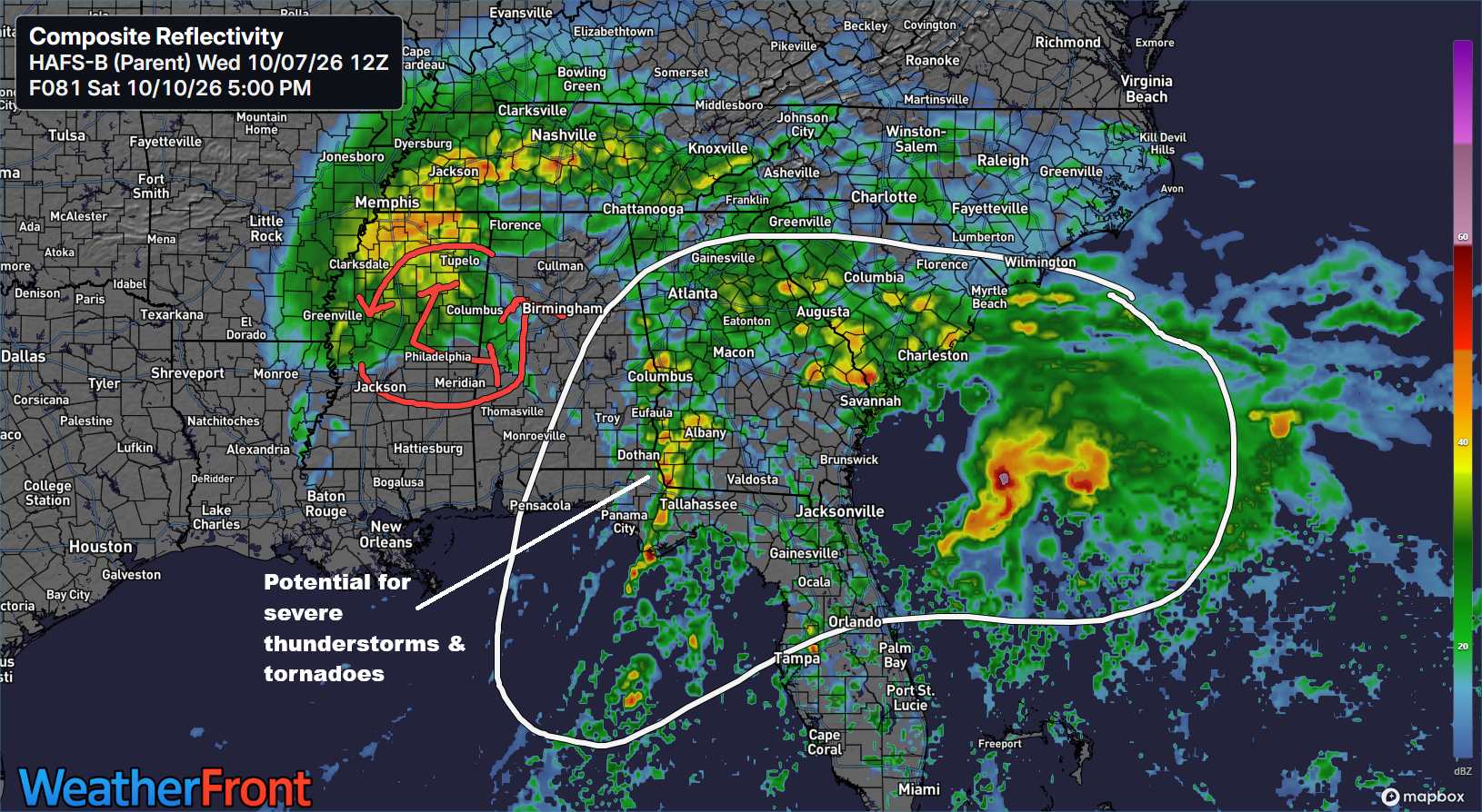
Instability is going to be a big limiting factor, but sometimes with a tropical cyclone and very high shear, that lack of instability may not matter as much.
Key point 3: Some form of a severe weather outbreak may occur east of where Isaias tracks on Saturday or Sunday after landfall.
So the bottom line in all this:
- * Folks on the Gulf Coast should prepare for a landfalling hurricane, possibly a borderline major hurricane, somewhere between Biloxi, MS and the Florida Big Bend, with the highest odds of landfall right now between Mobile and Destin.
- * Storm surge of 5 to 7 feet above ground at peak will be possible near and east of where Isaias comes ashore.
- * Landfall is likely to be Friday night in the affected area.
- * Heavy rain is likely across the Southeast resulting in pockets of flash flooding.
- * Severe thunderstorms and tornadoes are likely to some extent on Saturday and Sunday across the Southeast and perhaps into the Carolinas, but details are very fuzzy right now.
We’ll have more for you in the morning.