In brief: Today’s post reviews the seasonal activity we have seen so far in the Atlantic Ocean. Then we turn our attention to the next wave on deck, and potential mischief in the Caribbean Sea.
Wednesday marked not just hump day for this week, but also the statistical midpoint of the Atlantic hurricane season. It’s been an odd season so far. There has been one very powerful hurricane, Erin, which formed in August, and five modest tropical storms. Additionally, although Erin was by far the most intense and long-lasting system, arguably the season’s most impactful storm was Barry, which made landfall in Mexico as a weakening tropical depression. It was moisture from these remnants that contributed to devastating flooding in Central Texas over the Fourth of July holiday, causing more than 135 deaths and causing widespread damage.
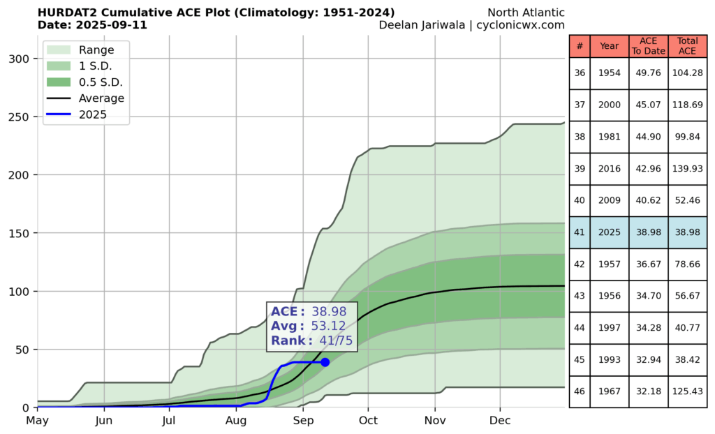
Total ACE for the Atlantic this season, through Wednesday. (cyclonicwx.com)
Going by raw statistics, the tally of six named storms to date is probably a little behind where we would expect to be during a season in which, on average, 15 named storms were predicted to form. In terms of Accumulated Cyclone Energy, which factors in the the duration and intensity of tropical systems, this season is running about 25 percent below normal. Without Erin, it is worth noting this season would be pushing historic lows in terms of overall activity.
So, overall, we are seeing less activity than is normal. Will that last?
Next wave up
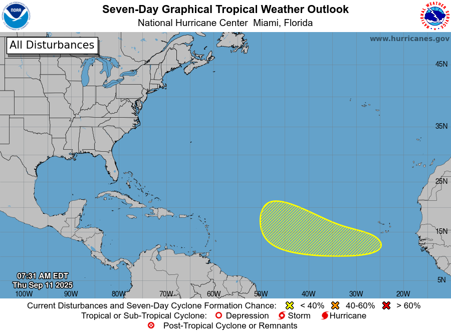
Yesterday the National Hurricane Center started to flag a tropical wave that has not yet even emerged off the coast of Africa, into the Atlantic Ocean. (As a quick reminder, because it can be a little confusing, when forecasters refer to ‘tropical waves’ they don’t mean large waves in the ocean, but rather perturbations in the atmosphere). Anyway, when it reaches the Atlantic, this wave should find favorable conditions for further development.
Seven-day tropical outlook from the National Hurricane Center.
Most of the various models we look at, including traditional physics-based models as well as AI models, have become fairly bullish on development of this system about a week from now. There is surprisingly good agreement among several of these models, and their ensembles, about where the disturbance will be by the middle of next week.
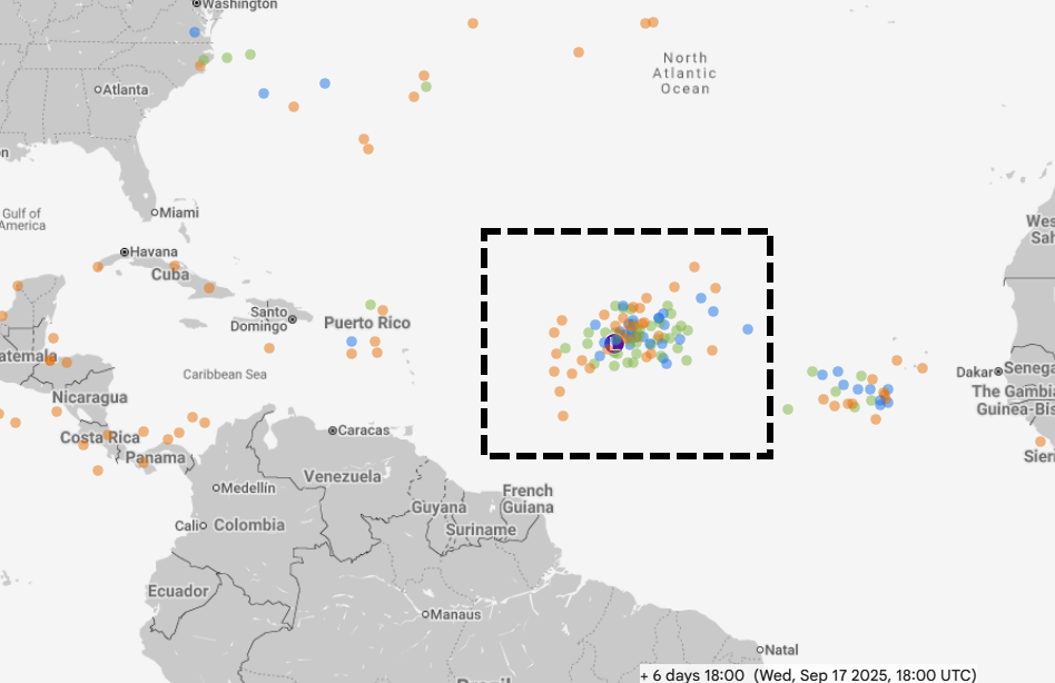
A smattering of AI and the ECMWF model predict the location of the tropical wave by next Wednesday. (Google Weather Lab)
After that point there’s not a whole lot of agreement, and at six or seven days we are entering the realm of speculation. Some solutions never really develop the system beyond a tropical storm while others bring a stronger storm close to Puerto Rico or north of the islands. Other models predict dissipation, and are a lot more excited about another wave that is several days behind this one. All of this to say: This is something we are going to have to pay attention to for awhile, since the second half of September can see storms get pretty strong, pretty quickly. It could be something. It could be nothing. We’ll see!
Home brews?
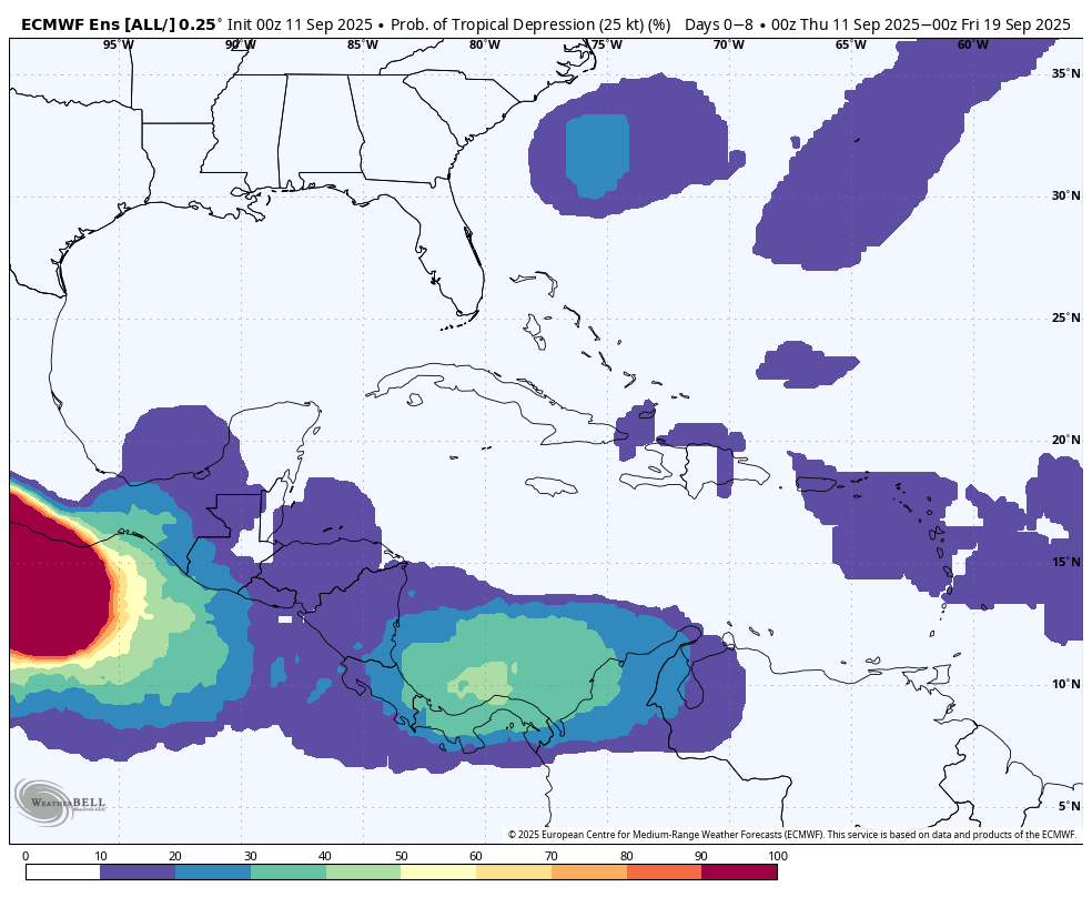
The other thing we’re watching for is development of a tropical system closer to home, possibly in the southern Gulf of Mexico or more likely related to the Central American Gyre, an area of low pressure over the eastern Pacific Ocean and western Caribbean Sea. There is nothing imminent here, but it is the time of year when this thing happens, and some of the models (such as the ECMWF, shown below) are splashing low-end chances for formation. Given the overall pattern in the Atlantic right now, the best odds for a storm getting into the Gulf of Mexico in September will probably come from this kind of home-brewed system. But that does not mean the overall odds are particularly high.
Odds of a tropical depression forming in a given location over the next 10 days. (ECMWF)
Given that we are presently right at the peak of the Atlantic season, this is pretty good place to be in with just a few nebulous threats. We’ll keep a close eye on things in the days ahead to see what, if anything, comes from all of this.
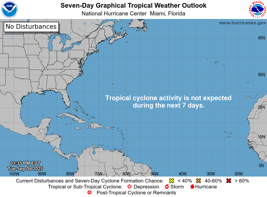
In brief: Why is the tropical Atlantic hitting the historical peak of activity with not a wave to be found? We explain the details below, but it looks quiet for the next 7 to 10 days. Beyond that, risks will surely increase a little but how much so remains a topic of uncertainty.
Happy Tuesday evening everyone. Late today due to participation in the National Weather Association’s 50th anniversary meeting in Huntsville, Alabama, a fine city. But I wanted to catch you up on the historical peak of hurricane season.
Tropics outlook
The next 7 days look quiet. (NOAA NHC)
The outlook is the “not stonks” meme for those of you familiar with internet culture.
I mean, truly, it’s just quiet as could be. Now, it does appear we may get a wave in about 7 days in the open Atlantic that could develop. But that’s the only game in town for the next 10 days it would appear.
The next wave will emerge off Africa in a few days and may develop in 7 to 9 days in the open Atlantic. (Weathernerds.org)
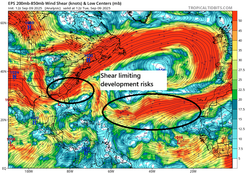
An upper low in the central Atlantic, known as a “TUTT” is imparting shear on basically anything that comes off Africa, so they instantly hit a hostile environment. Additionally, there is a lot of drier air in the open Atlantic, which is not helping anything. TUTT lows drag down drier air from the subtropics into the tropics. A lack of instability, drier air, and shear are all decimating any chance at development right now. Climatology is as good a guide as anything when you look at seasonal predictability and timeframes for activity, but if the key ingredients aren’t there, they aren’t there. The cookbook recipe may say that the cake needs flour, butter, and eggs. But if you leave the flour and butter out, you aren’t baking a cake using that recipe.
Strong wind shear is hampering development, in addition to other factors. (Tropical Tidbits)
In addition to this, in the western Atlantic there is high wind shear as well. So we have a number of highly problematic factors right now as it relates to tropical development. Good for almost everyone!
Now, after 10 days the forecast in the Atlantic seems to favor a slightly more favorable shift for tropical activity. At least we should see more instability out there. That being said, I have seen a couple instances this hurricane season where tropical Atlantic conditions were expected to become more favorable “in 10 to 14 days,” and those conditions ultimately never materialize. That could be true here too. But given our streak of good luck, one figures it can only last so long. At the least, we will probably start to see GFS operational model runs showing tropical development in the Caribbean or Gulf soon. Please remember that this model has a very well-known bias to overdo that activity in most cases, particularly beginning in later September and October, as well as in May and June.
Bottom line: Enjoy the respite from peak season activity. But we still have about half the season’s activity in front of us historically. We’ll keep you posted.
In brief: Today, we reflect on the 1900 Galveston hurricane, which made landfall on this day 125 years ago. The lessons before and after the storm ring loudly today in an age where disaster is happening to more people more frequently.
On July 16, 1891, a byline in the Galveston Daily News attributed to Dr. Isaac Cline was published. The sub-headline read “Record of twenty years — The Texas Coast Not Liable to Serious Damage.” Essentially, Cline was using the best knowledge of how things worked at that time to try to explain why he believed the Upper Texas Coast was immune to disasters, such as the 1875 Indianola Hurricane.
July 16, 1891 Galveston Dailly News. Click to enlarge.
After seeing what happened to Indianola in 1875 and again in 1886, some residents of Galveston had felt they needed a seawall for protection of the city. Cline, among some others did not believe this was necessary. In fact, in this 1891 article, Cline wrote this:
The opinion held by some, who are unacquainted with the actual conditions of things that Galveston will at sometime be seriously damaged by some such disturbance is singly an absurd delusion and can only have its origin in the imagination and not from reasoning; as there is too large a territory to the north which is lower than the island over which the water may spread, it would be impossible for any cyclone to materially injure the city.
While it may seem patently absurd today that any learned individual would ever say something like that with such confidence and in that tone, keep in mind again the context of the day. This was not a deranged individual. This was how even brilliant people thought about things in that era. But in hindsight, it tells us a lot about hubris and an invincibility complex.
The storm
It was today 125 years ago that hell was unleashed on the Texas coast. The great Galveston hurricane remains the deadliest single weather event in our nation’s history. Despite how it may seem in hindsight, it wasn’t inevitable. And despite it happening 125 years ago, it remains as relevant today as it was in 1900. Most of us know the general theme of things. The hurricane struck Galveston, delivering the full fury of the Gulf of Mexico onto the island, washing away virtually every structure on the Gulf side of the island. The death toll ranged from 6,000 to 12,000 based on various estimates. The storm’s impact was well documented in several books. Obviously, “Isaac’s Storm” comes to mind first and foremost, telling the story through the life of the weather bureau chief in Galveston, Isaac Cline. “A Weekend in September” remains a classic for this topic as well. I am fortunate to also own an original copy of the “The Great Galveston Disaster,” which contains accounts and details of the storm’s impacts.
But the Galveston storm also had noteworthy impacts near and far from Galveston.
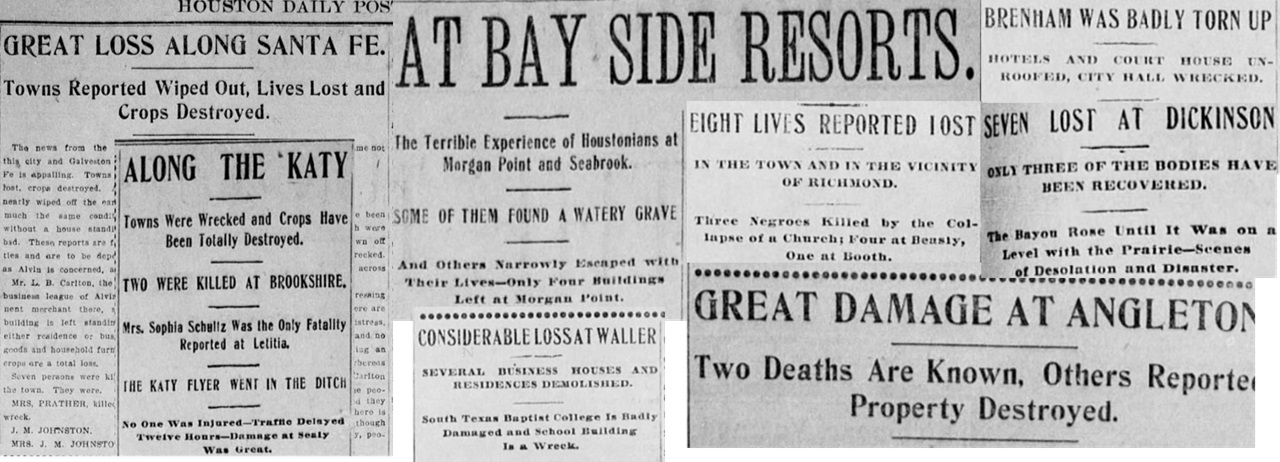
A selection of headlines from the Houston Post describing loss across Southeast Texas.
Across Southeast Texas, damage was everywhere. Bayshore communities were devastated with significant loss of life. Inland locations from Houston to Richmond to Brenham suffered extensive, widespread damage and lesser but not inconsequential loss of life. A similar storm today, a large category 4 hurricane would probably cause north of $100 billion in damage, with significant risk to the Houston Ship Channel, an economic engine for both Texas and America.
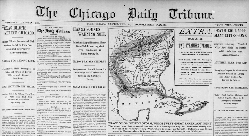
The 1900 storm remained a tropical storm into Oklahoma before it became post-tropical. But the 1900 storm was clearly fueled by the jet stream after that, and it reintensified as an extratropical cyclone over the Midwest and Great Lakes.
“Texas Blasts Strike Chicago” (Chicago Tribune)
As the storm moved into the Great Lakes it produced wind gusts over 80 mph in Chicago, 78 mph in Buffalo, and 74 mph in Toronto. Flooding occurred in Minnesota, two were killed in Chicago, and “severe damage” was reported in Buffalo.
As it passed north of an extremely dry New England, it helped fuel significant wildfires that broke out in southeast Massachusetts and Cape Cod.
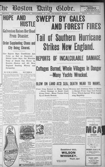
New England “swept by gales and forest fires.” (Boston Globe)
Water scarcity had been a problem in 1900 in New England, with shortages reported in New Hampshire and Connecticut. The passing of the hurricane, with drier air on the back side and gusty winds led to a rough setup that helped produce fires.
In Canada, the damage was immense in the Maritime Provinces with strong winds and numerous shipwrecks. Over 50 were confirmed killed in Canada, making the 1900 storm the 8th deadliest storm on record there. However, unofficially, the toll was likely higher, and the 1900 storm may be as high as the third deadliest (possibly over 200 perished).
Recall at the beginning of this post, we noted how the 1875 Indianola hurricane planted the seed that never germinated in time. After the storm, the reaction was quick. The Seawall began construction in 1902 with the first segment completed by 1904. The length was over 3 miles. An additional extension just under a mile was completed in 1905 to protect Fort Crockett. The first three miles were approved by the Texas Legislature and funded by the issuance of bonds in Galveston County. The section protecting the fort was funded by Congress. The Seawall was further extended in 1927 and again in 1963. In addition to that, 500 city blocks were raised in elevation by 1911. This was the largest civil engineering project in American history at that time and stands as one of the most enduring.
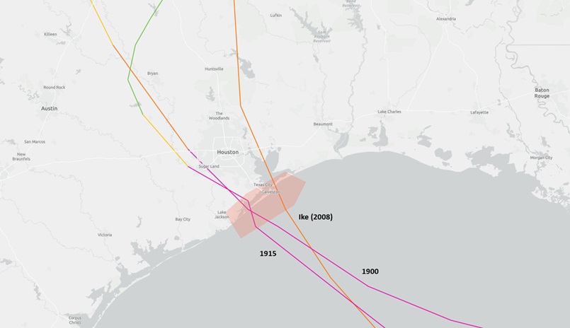
The track of the 1900 Hurricane vs the track of the 1915 hurricane vs Hurricane Ike in 2008. (NOAA)
The Seawall paid dividends almost immediately. In 1915, a very similar storm to the 1900 one struck nearly the same exact place. We’d be the first to tell people that no two storms are identical, but in this instance, the difference was so dramatic, it needs mention. While the 1915 storm did do a fair bit of damage, the devastation that was seen in 1900 was not repeated in any way. The loss of life was around a dozen in Galveston proper, with many others lost elsewhere on Galveston Island and along the bayfront closer to Texas City. But the Seawall stood the test. It was the true definition of hazard mitigation.
When Hurricane Ike hit in 2008, the damage in Galveston proper was primarily caused by bayside flooding, as Ike took a slightly farther north track. The Coastal Barrier project, or “Ike Dike” as it’s commonly called would substantially mitigate this type of flooding, further bolster the Gulf side risks, and provide a layer of protection that does not currently exist for the Houston Ship Channel.
The 1900 storm still matters a lot today for the toll it took and the lessons it left behind
I’ll say it again: Hurricane Ike hit the Texas Coast in 2008. 17 years later, the Ike Dike is a plan on paper that’s funded sort of, but not really. After 1900, the people of Galveston recognized what had to be done and did it. It’s a different world today of course, and these projects are more complicated, more thorough in planning, done more safely, and they’re just more expensive. But here’s the thing about large mitigation projects: They save more than they cost. The Galveston Seawall is a testament to that. It was created as a reactive solution to a permanent, existential problem. What has it done? Saved hundreds of millions of dollars in damage and countless lives. Will the Ike Dike do the same thing? The better question may be: Would the Seawall have prevented the 1900 tragedy? The answer is probably yes, even if in truth, there’s no way to know for sure. But the plans for the Ike Dike seem reasonable, and we know that mitigation money pays back about $6 in avoided damage for every dollar invested.
Ingenuity and a sense of existential risk to a community brought people together after 1900 to plan and implement a radical change. As we move forward through the 21st century, we are going to need that same sense of thinking for the greater good of our communities. It’s likely that some communities will face existential threats to their survival, be it through sea level rise, storms made worse by warming oceans, or simply infrastructure that’s unfit for the current population. These risks aren’t unknown. We know what many risks to our communities are; they aren’t theoretical. Had Galveston followed down that line of thinking in the 1890s, the 1900 storm may have been a footnote in history. The lesson from 125 years ago stands today: Proactive investment in hazard mitigation for our communities allows them to survive and prosper, and that’s good for everyone.
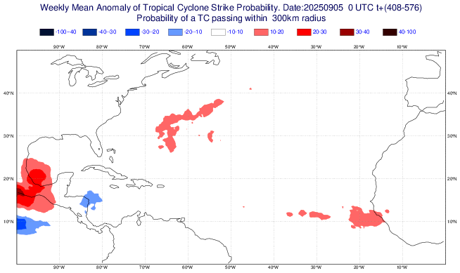
In brief: Invest 91L is going poof in the eastern Atlantic, so we do some informed speculation on what happens next, which is to say nothing imminent. Meanwhile, Kiko is likely to pass north of Hawaii, with few direct impacts but some serious surf potentially.
Invest 91L: See you later!
Being in Houston, I want to invoke my inner Robert Ford (Astros radio broadcaster) and shout “See you later! See you later!” regarding Invest 91L.
What’s left of Invest 91L
Invest 91L was always a curious case. Earlier this week, I noted that with the small size of the wave “storms like that have a window to do what the operational modeling says they’ll do. And if they miss the window, you can forget development.” Well, it seems 91L missed the window. Odds of development have dropped from 90 percent 24 hours ago to 30 percent this morning, the first time I can recall such a precipitous drop off in development risk from the NHC. There is virtually no more model support for development out there. Could it make another attempt as it approaches the islands? I guess it could, but that seems far less likely than the alternative, which is nothing at all. If you live in or have interests in the islands, keep an eye on this, but you can probably sleep a little easier.
What else is there in the Atlantic?
Well, modeling is pretty excited about the next wave, particularly AI modeling. Where have we heard this before? AI modeling has had an interesting go of it this hurricane season. For specific storms, it has done fairly well. For genesis of still-not-developed storms it has had mixed results. A lot of false alarms peppered in, and it could be that the Atlantic is just too hostile this year. Perhaps in 2020 or 2017 we would have seen these systems actually make a run at development, but in 2025, whatever appears to be holding things back is having a say.
AI ensemble modeling favors development in about a week or so of the next wave off Africa. (Weathernerds.org)
In this case, there seems to be some support, and the background state of the Atlantic should, in theory, be improving. I am not as bullish on this happening as some others are at the moment. However, it does look like the post-September 20th period may be when we finally get a chance to get busy in the Atlantic.
Tropical cyclone anomaly forecast from Friday’s European weeklies for the week of 9/22-9/29 (ECMWF)
It may begin in the southwest Gulf, or it may begin via some sort of Central American gyre, a common later season pathway to development. It’s too early to speculate on anything specific, but I would probably say that the last week and a half of September looks at least more interesting in theory than the rest of the month. We’ll see.
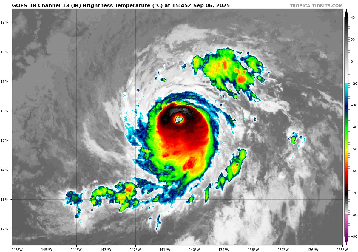
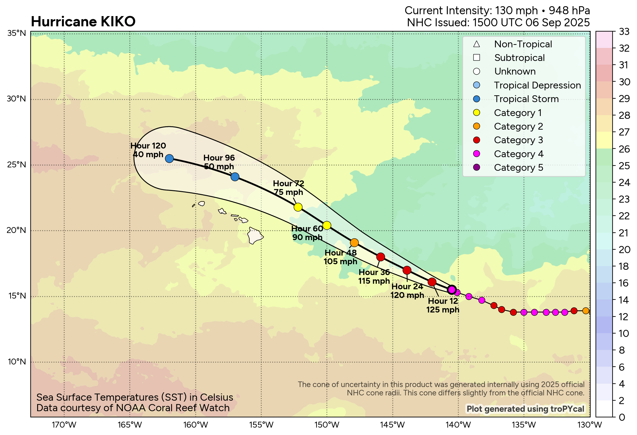
Kiko’s brush with Hawaii
Hurricane Kiko blew back up with authority yesterday afternoon and evening, reattaining category 4 intensity. Kiko is currently responsible for about 30 percent of the Eastern Pacific’s accumulated cyclone energy this season, a pretty impressive storm.
Hurricane Kiko should begin to gradually weaken later today. (Tropical Tidbits)
Kiko will continue west northwest toward Hawaii, but model guidance has begun to shift north off the islands a bit in the last 24 to 48 hours.
Kiko should pass just north of the Hawaiian Islands. (Tomer Burg, polarwx.com)
With Kiko’s path north of the islands, this will probably mean most of the direct impacts will remain away from land. Clouds, showers, and humid weather will probably arrive as Kiko passes by, with heavier rain risks on the east and north upslopes of higher terrain. It may be a surfer’s paradise at times, particularly on east facing shores. But waves all over the islands may be a bit rough at times early next week. In addition, some minor coastal flooding is possible with Kiko in the vicinity and peak high tides for the month occurring.