In brief: We take a big picture look at what will push Tropical Depression 5 likely into Tropical Storm Edouard later tonight, as well as what will impact its intensity going into tomorrow. We talk about the wind potential on the coast and the flooding potential inland.
Over at Space City Weather, Eric takes a look at how TD 5, or what should become Edouard will impact the Houston area. My purpose here is to zoom out a little and take a look at TD 5 from a larger perspective.
First, as of this evening, the storm center of Tropical Depression 5 is located south of Vermilion Bay, Louisiana. Maximum sustained winds are 35 mph, so we’re not yet at tropical storm intensity.
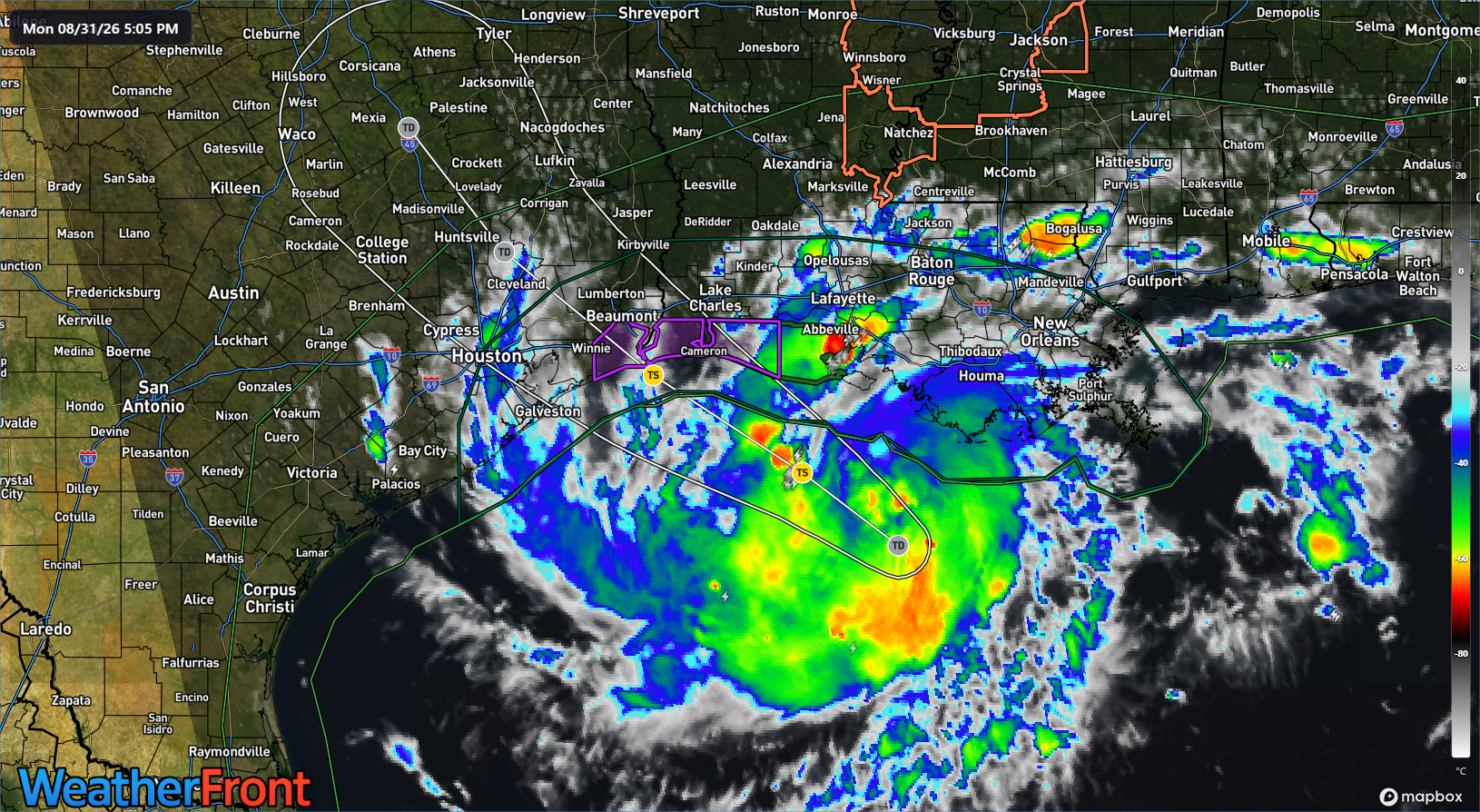
There has been hurricane hunter activity in the depression throughout the day, and the read is that the circulation is becoming better defined. They’ll be back out tonight, and given how things have gone today, I would not be the least bit shocked to see this upgraded to a named storm with the 10 PM CT advisory.
The track forecast for TD 5 is actually relatively straightforward and simple. It will continue west northwest to northwest and make landfall somewhere between High Island, TX and Cameron Parish, LA tomorrow afternoon or evening.
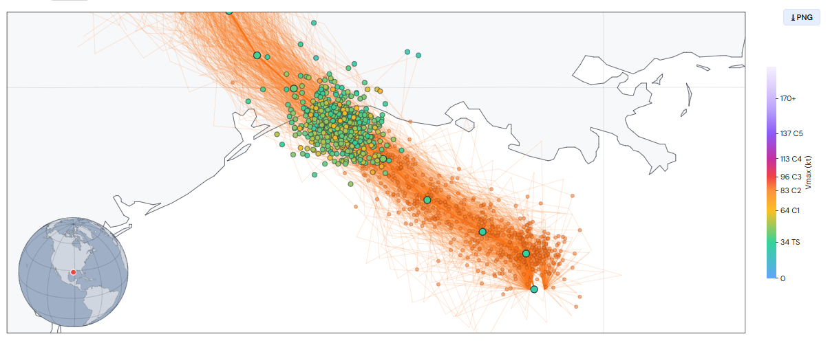
TD 5 has about 24 hours over water to do whatever it will do.
So, what will it do? Normally, we’d look at a system like this and say, “Ok, weak to maybe moderate tropical storm, and that’s that.” TD 5 is slightly different. It’s small, it’s healthy “under the hood,” and it’s over very warm water in an extremely low shear environment. The key in that sentence is that it’s small. Small storms deserve love too. And in fact, sometimes these smaller storms can thrive in this part of the world, easier to wind up. And with only 24 hours over water, this storm will probably come ashore while intensifying, meaning it may punch a little above its weight class in terms of coastal impacts.
The latest NHC forecast brings TD 5 to 60 mph at landfall near Sabine Pass, TX. About 20 percent of Google 1,000 member ensemble members bring TD 5 above 60 mph at landfall, with about 5 to 10 percent doing so as a hurricane. Google’s operational WN2 model is not as excited with this, but I think this is an excellent use case for a 1,000 member ensemble. It gives you a more adequate dispersion of members in terms of intensity, and with small storms that can easily fluctuate like this one should, that’s helpful.
Let’s talk about the potential of a higher-end outcome. Let’s say TD 5 becomes a hurricane. Heck, even just a strong tropical storm. What sort of wind would we be looking at here? The answer is “a very compact, localized” wind field that would quickly drop off as it moved inland.
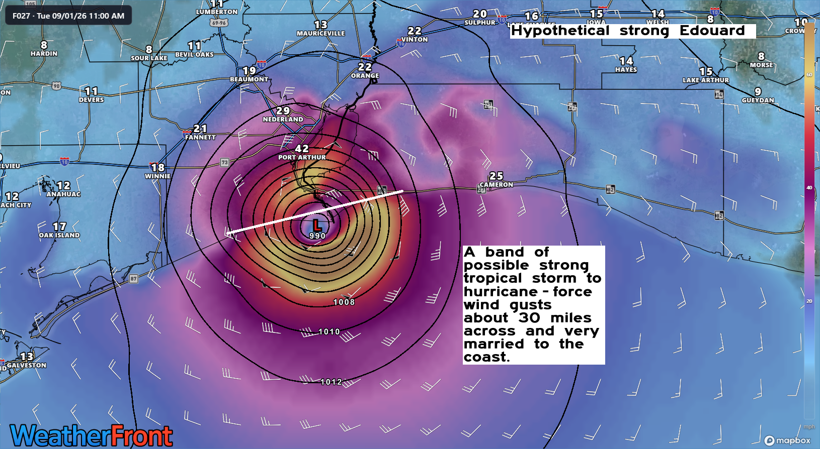
In this scenario, you’d have strong tropical storm or hurricane-force gusts on the immediate coast between High Island, TX and about Johnson Bayou, LA. And the western flank of that may even be a little generous. By the time you got to Winnie, Nederland, Beaumont, Orange, Vinton, or Sulphur along I-10, you’d be talking about low-end tropical storm force wind gusts. At best. The storm would weaken rather fast once onshore, and this would likely substantially crush the wind intensity. In fact, if you run the HWRF, shown here, out 3 hours from here, you get max wind gusts in the 40s south of I-10 and 30s north of I-10.
Also, notable since the broader media will tie this into “Greater Houston,” this outcome would keep tropical storm force winds away from the entirety of the Houston Metro area, except maybe, maybe Galveston and Bolivar.
So, if you live on the coast or just inland between High Island and Johnson Bayou, I encourage you to prepare as if a strong tropical storm or Category 1 hurricane were coming.
In terms of rain, the good news is that the system looks generally progressive. The remnant center of it should be somewhere south of Dallas or east of Temple by Wednesday afternoon. But, the system is rather moisture-laden, so it will be able to dump some hefty rain near where the center tracks. In general, I would expect about 1 to 3 inches of rain east of I-45 with a band of 3 to 7 inch totals along the center track. That’s what should track through western Jefferson, eastern Chambers, Liberty, Hardin, Tyler, Polk, and San Jacinto Counties. Within that 3 to 7 inch corridor, there could be a bullseye closer to 10 inches in one or two spots.
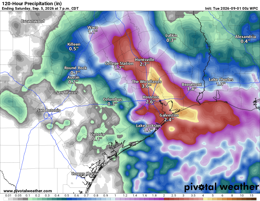
In the Houston Metro, we cover that at Space City Weather, but there is likely to be a very sharp gradient where parts of the area see nothing at all, up to an inch, then a quick escalation to 3, 4, 5 inches or more somewhere east of I-45. For Beaumont-Port Arthur, this looks like the heaviest rain will fall south and west of those cities, but it’s possible we see over 3 inches in spots. An inch or so is possible in Lake Charles, as well as around the periphery of where TD 5/Edouard “dies” in Texas, be it near Waco or Lufkin.
While this is probably not a severe flooding risk, there will be pockets of flash flooding possible later tomorrow through Wednesday morning, so just be advised of that in those areas.
We’ll update the situation again in the morning. Stay safe!