In brief: Today’s post takes advantage of a quiet tropics to explain what ridge riding thunderstorms are, as you may be hearing a bit about those in addition to heat next week across a swath of the Central and Eastern U.S.
There’s nothing to report in the Atlantic tropics, so today we’ll talk about a topic that will become more relevant in the coming peak summer heat: Ridge-riding thunderstorms.
What are they?
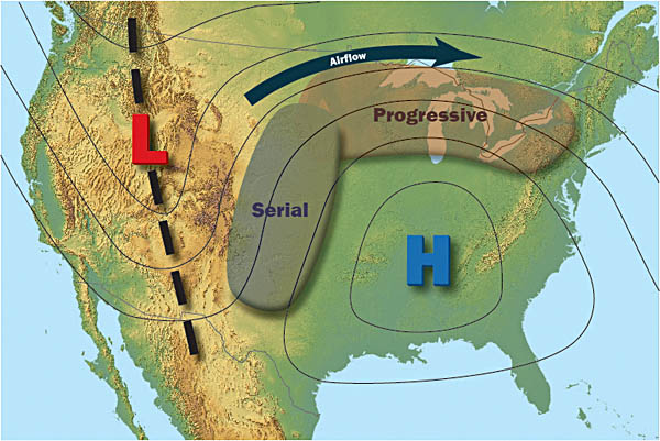
Well, the name tells you everything. They are thunderstorms that develop and ride the periphery of high pressure in the upper atmosphere. These tend to occur most often in the summer months. We sometimes refer to this as “ring of fire” thunderstorms or “ridge rollers.”
How and where do they form?
Like any thunderstorm, you need rising air, instability, and moisture. All of those are usually present around the periphery of high pressure ridges, or what you often hear referred to as “heat domes” or “death ridges.” High pressure itself indicates sinking, hotter air, so underneath the ridge, it’s dry. But on the outskirts? Not so much. In fact, instability is typically pretty potent in those areas, as you’re straddling the border between very hot, dry air and cooler air. This is why the storms usually initiate on the top (poleward) side of the ridge, not on the southern periphery. Northern areas are also closer to the jet stream, offering some extra punch. Areas on the southern periphery of the ridge can see storms too but the overall instability, temperature contrast, and proximity from the jet stream work against them.
Are they usually stronger than typical summer thunderstorms?
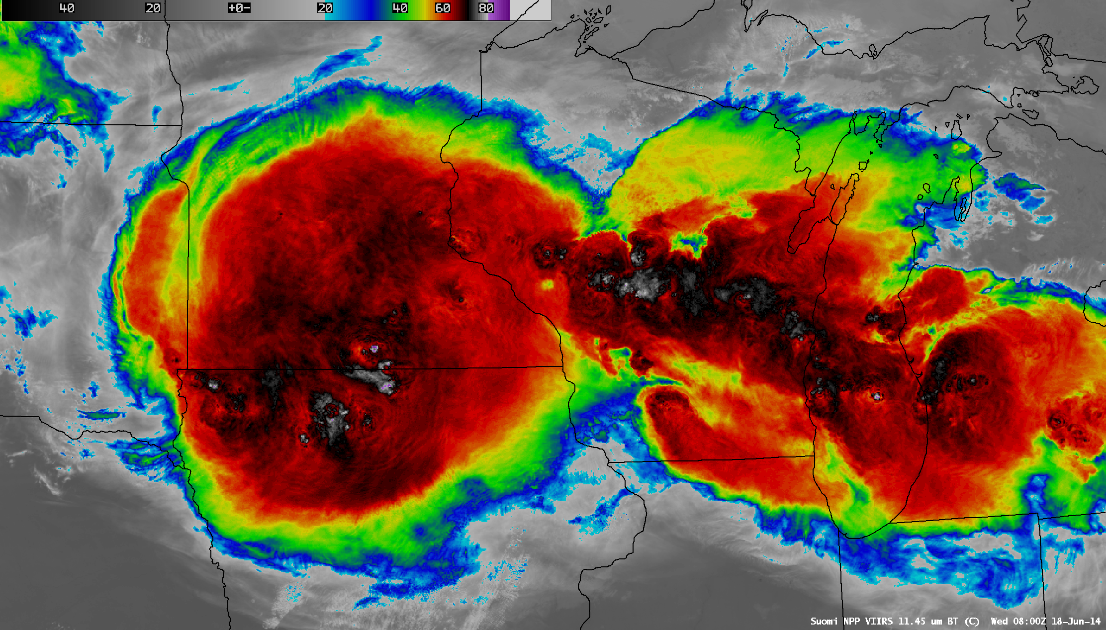
They can be, yes. There’s a pretty decent connection between intense heat waves in the Central U.S. and derechoes, or the strongest of these strong clusters of thunderstorms that produce widespread, significant damaging wind. Not all heat waves will produce derechoes. Not at all. But many historic derechoes have occurred in heat waves. There are numerous exceptions, of course. But there is a connection. The reason is that as these thunderstorms develop with daytime heating, somewhere on the ridge periphery, depending on upper level disturbances, etc., they often quickly organize into “clusters” of thunderstorms. Those clusters can often then develop into a more organized complex of thunderstorms, known as a mesoscale convective system, or MCS. In most cases, these complexes of storms will produce scattered severe weather and torrential rain. But periodically, we can get some that overachieve. Those are the ones that usually go on to acquire derecho status.
Dry air from heat domes or high pressure ridges in close proximity to these storms can often infiltrate the storms aloft. That matters because while dry air in general inhibits thunderstorm development, a layer of dry air in the mid-levels of the atmosphere can turn an ordinary cluster of storms into a potent one.
What part of the country sees these most?
Usually in summer, this type of pattern is most likely to occur with a Plains or Midwest ridge of high pressure, and the thunderstorms will tend to follow the periphery across the Upper Midwest and Great Lakes, periodically into Upstate New York, New England, or parts of the Mid Atlantic. Occasionally, you can get strong to severe storms that plow across the Plains, much like we saw this past weekend in Oklahoma and Arkansas.
Why do they often occur at night?
Well, as noted above, the initiation of these storms often occurs during the late afternoon and evening, as is typical for summertime storms. However, as they organize and cluster, they will keep going through the night, often fueled by internal dynamics and a low level jet stream (strong winds around 5,000 feet up) that tend to help them maintain their intensity or at times intensify further. These storms transition from surface based, which means heating at the surface and instability develop the thunderstorms to “elevated,” which occurs when you lose most of the instability available as temperatures cool. Precipitation varies diurnally, especially in the Plains, where the maximum average precip actually occurs at night, not during the afternoon. Frankly, it often gets difficult to sustain these complexes of thunderstorms after sunrise, as you lose the nighttime low level jet, the cloud cover and leading cool air ahead of the storms further stabilizes the atmosphere, and you see cloud tops begin to warm up (stronger storms have colder air at their tops).
What are the hazards with these types of storms?
Again, as noted above, some (not all or even many, but some) have become historic derecho events, like the 1995 Adirondack blowdown or the June 2012 Mid-Atlantic derecho. Most others never get remembered in history but can cause locally significant damage. But all threats tend to exist with these storms: Wind, hail, tornadoes. Straight-line winds are far and away the biggest threat (in addition to prolific lightning). But hail and tornadoes can and occasionally do occur, especially as the storms initiate early on. Additionally, heavy rainfall is likely with these systems, and depending on the ground conditions ahead of the event, they can cause flash flooding.
So, next week?
Yes, we may get a good example of ridge rolling thunderstorms next week. If we look at the operational European model, you can see a couple of things happening. First, the ridge will prominently expand. We’ve already seen messaging from the National Weather Service on the heat potential next week.

Second, if you follow the Euro here, you’ll see that ridge expand but also a lot of yellow and orange color riding along top of it. What we’re looking at is 500 mb vorticity. Each time one of these passes by, it’s indicating a potential “seed” for thunderstorm complex development basically.
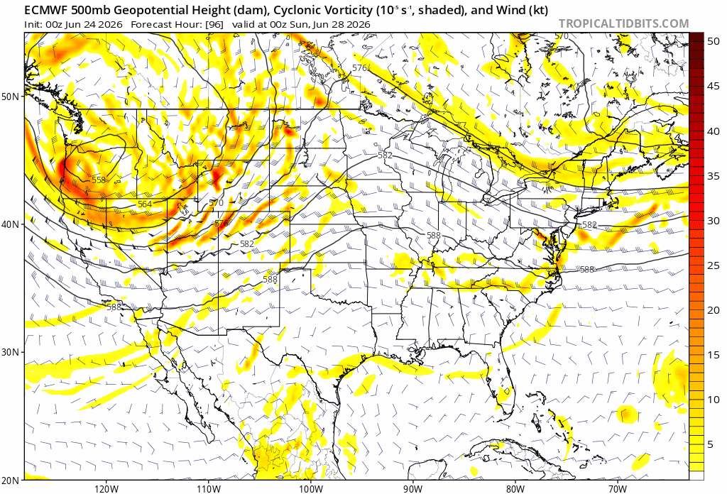
There are at least 2 or 3 of them showing up in the model between Sunday and Saturday next week. So I would anticipate we see at least a couple days of some severe weather risk across the Northern Plains, Upper Midwest, or Great Lakes. The Storm Prediction Center discussion this morning for day 5 and onward says as much:
Severe weather will be possible across portions of the Northern
Plains into the Upper Midwest Sunday and into next week. However,
predictability remains too low to highlight areas in this timeframe.
The presence of strong to very strong instability across a large
region with multiple shortwave troughs emerging from the primary
trough centered over the West will surely support severe weather
potential most days. However, probabilities for specific areas
cannot be added until the upper-level pattern becomes more clear. – SPC Wednesday AM discussion
So the point of today’s post was to educate you a bit on why you see this happen in summer but also do so in a timely manner because you’ll probably see it in action in a few days!