In brief: We check in on the state of the tropics, how El Niño is already impacting the season, and what we may see in the coming weeks. We also discuss how to not fall for engagement bait.
It’s August 3rd as I write this, and suffice to say, it has been a delightful tropical season for those of us who don’t want major hurricanes impacting communities. Arthur, while not the full cause of flooding in Louisiana and the broader Deep South, remains the most notable of our two storms so far. Our ACE has accumulated to 2.6 units thus far, not the lowest we’ve ever seen, but certainly on the lower end of the spectrum of recent years.
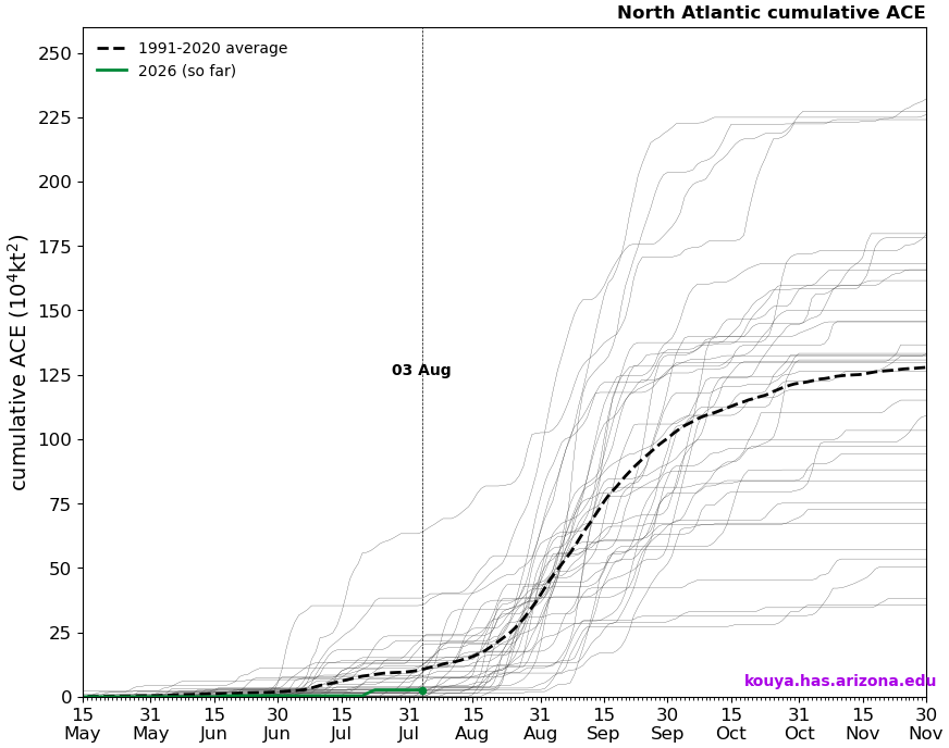
We typically average about 10 units of ACE by this point in the season, although that still only accounts for about 8.5 percent of total hurricane season. So, we’re a long way from the finish.
How has hurricane season been so quiet? Well, for one, it’s normal to be quiet in the first 2.5 months of the season. We’ve seen some catastrophic examples of that going awry over the years, but by and large, those years are very much exceptions rather than rules. So, climatology is your friend. But beyond that, there’s been the El Niño that has been talked up to the moon over the last few months. And it’s worthy of the hype; it’s one of, if not the strongest El Niño we’ve seen to this point in the modern era. El Niño means wind shear in the Atlantic, and big El Niños mean big wind shear. This year? No different.
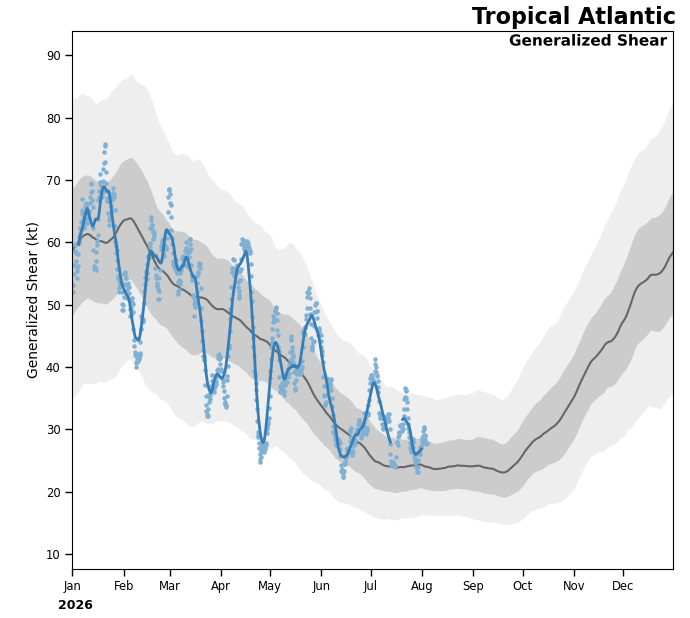
Other than perhaps a few days in early to mid-June, wind shear in the Atlantic basin has been average to well above average this season. The Gulf and subtropical Atlantic has been a bit more subdued, whereas the Caribbean has been raging with shear. So El Niño is doing its thing.
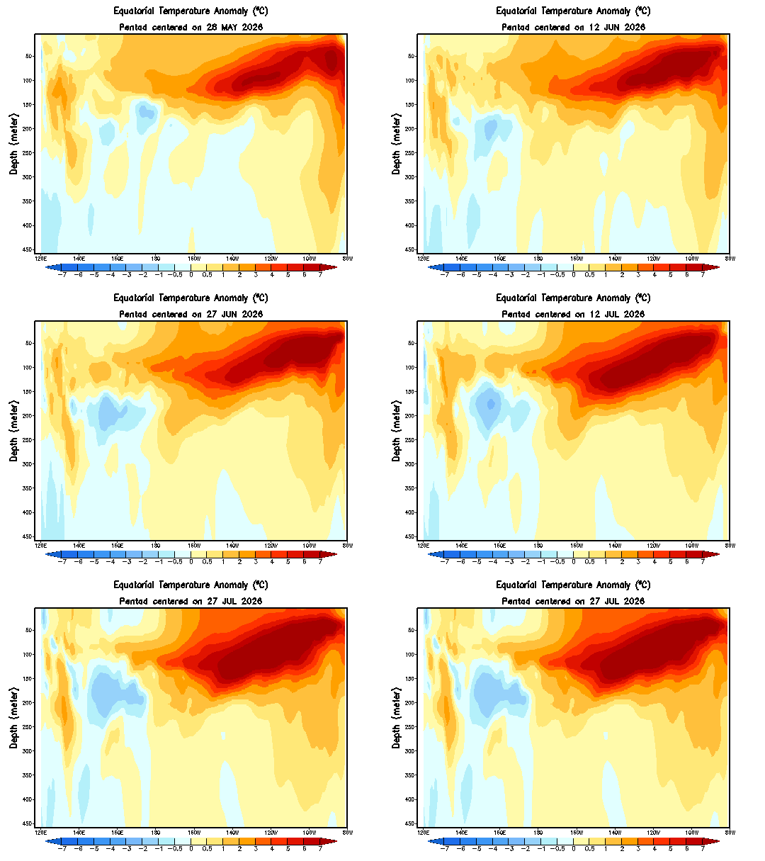
And in fact, this particular El Niño remains on pace to become a first ballot hall of fame event. This event has been building and building all summer long. When you look at the total depth of the water temperature anomalies, you can clearly see that this event is absolutely romping.
As a sidebar, one thing I want to make sure the general public understands about this and the media ecosystem and content creation system today: You are going to hear people start making bold proclamations about El Niño and winter. Yes, winter. In August. It’s nonsense. People will cherry pick the most exciting (read: cold/snowy) model they can get their hands on for winter to basically draw you into engagement. They’ll couch it in language like, “This is only one solution, and it’s not necessarily likely to happen, but when I see this, I take notice!” It’s a digital dopamine hit. And it’s just not right, nor is it being a meteorologist. It’s picking a cold model because they know you, the reader or viewer gets excited about that, and it will spur you into engagement, which in turn helps you to feed the beast, as it were. It used to be rogue “social mediarologists” that did this, but it has gotten far worse and extended into professionals that know (or should know) better, particularly on the broadcast side of things. And a lot of the legacy media tries to draw you in with big, bold headlines too. Bottom line: If someone is selling you a historic cold or snowy winter right now, don’t buy the hype. Sure, there could be a storm or two — as happens almost every winter. That’s not exactly a forecast; it’s called climatology. This winter is likely to be historic in some way given the El Niño, but real history points toward either a very warm planet or high precipitation values and drought in various different parts of the globe.
Anyway, off the soapbox. El Niño is feeding the wind shear machine. The other issue? Water temps. The Gulf? Warm. The Caribbean? Less warm. The Atlantic Main Development Region? Not warm at all.
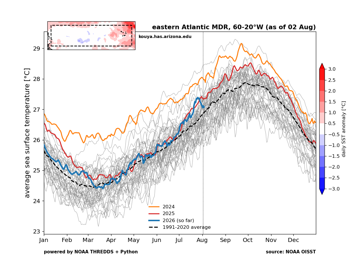
We are near climo in the deep tropics. And that’s not going to cut it with this sort of wind shear environment we are in. Basically, this points to development occurring through closer to home systems that could fire up if wind shear relaxes for even a couple days at the right (wrong) time. Or by waves, disturbances, or remnant fronts that make it closer to the much warmer subtropical latitudes off the East Coast or in the open Atlantic. We could still see a few weaker tropical systems out in the deeper Atlantic. But Cabo Verde season seems increasingly unlikely to replicate what Cabo Verde’s soccer team did at the World Cup this year.
Still, watch we will. But at this time, all looks quiet the next week or two.