In brief: As the Atlantic presses the mute button, the Pacific is churning storms out like a factory. The one of most concern is Hurricane Lowell, which could directly or indirectly threaten Hawaii early next week.
First of all, a special thanks to all our new subscribers and followers over the last few days with Edouard looming. Hopefully you find The Eyewall to be a useful resource for your weather consumption diet.
Edouard latest
Rain totals are finalizing in parts of Texas worst impacted by Edouard. A gauge along Little Pine Island Bayou in Hardin County measured over 24″ of rain from Edouard. A gauge on the Hardin/Tyler County line reported almost 18″, and another one just north of there near Warren, TX reported just under 17 inches.
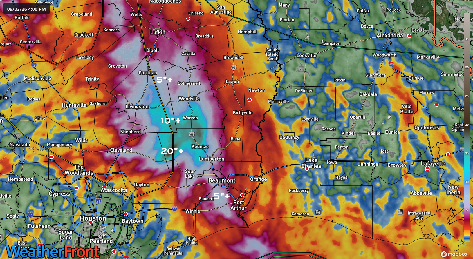
A CoCoRaHS gauge near Kountze picked up over 13 inches as well. This was a truly classic inland flooding event. Given the impact region’s low population density, we’ve seen scattered reports of rescues and damage. I’m sure more details will reveal themselves in the coming days.
Atlantic tropics
It does not get any quieter than this in early September.

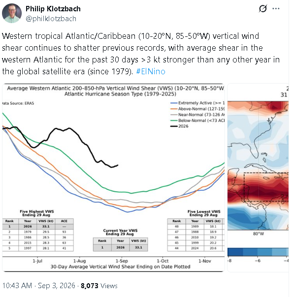
Google’s ensemble model shows next to nothing out there. The same can be said for most other modeling I’ve seen, from the Euro to the AIFS to even the usually more active GEFS. Subseasonal forecast data from the European Centre seems to imply activity will remain below 50% of normal over the next 3 to 4 weeks. This is par for the course in a near-record strong El Niño. As Dr. Philip Klotzbach, noted on X earlier today, wind shear is at record levels by a wide margin right now. Edouard showed the narrow way we can circumvent that. Dolly showed how the Atlantic will probably govern itself the rest of the season. If anything is going to occur through October, it will almost certainly do so close to home and at the last minute.
That’s all I got.
Hawaii targeted again
The Eastern Pacific has been very active and will likely remain very active over the next 4 to 6 weeks, as is typical in El Niño, further aided by abnormally warm water all the way up to Baja and California. We have Marie and Karina out there now. But we also have Lowell, and Lowell is a problem.
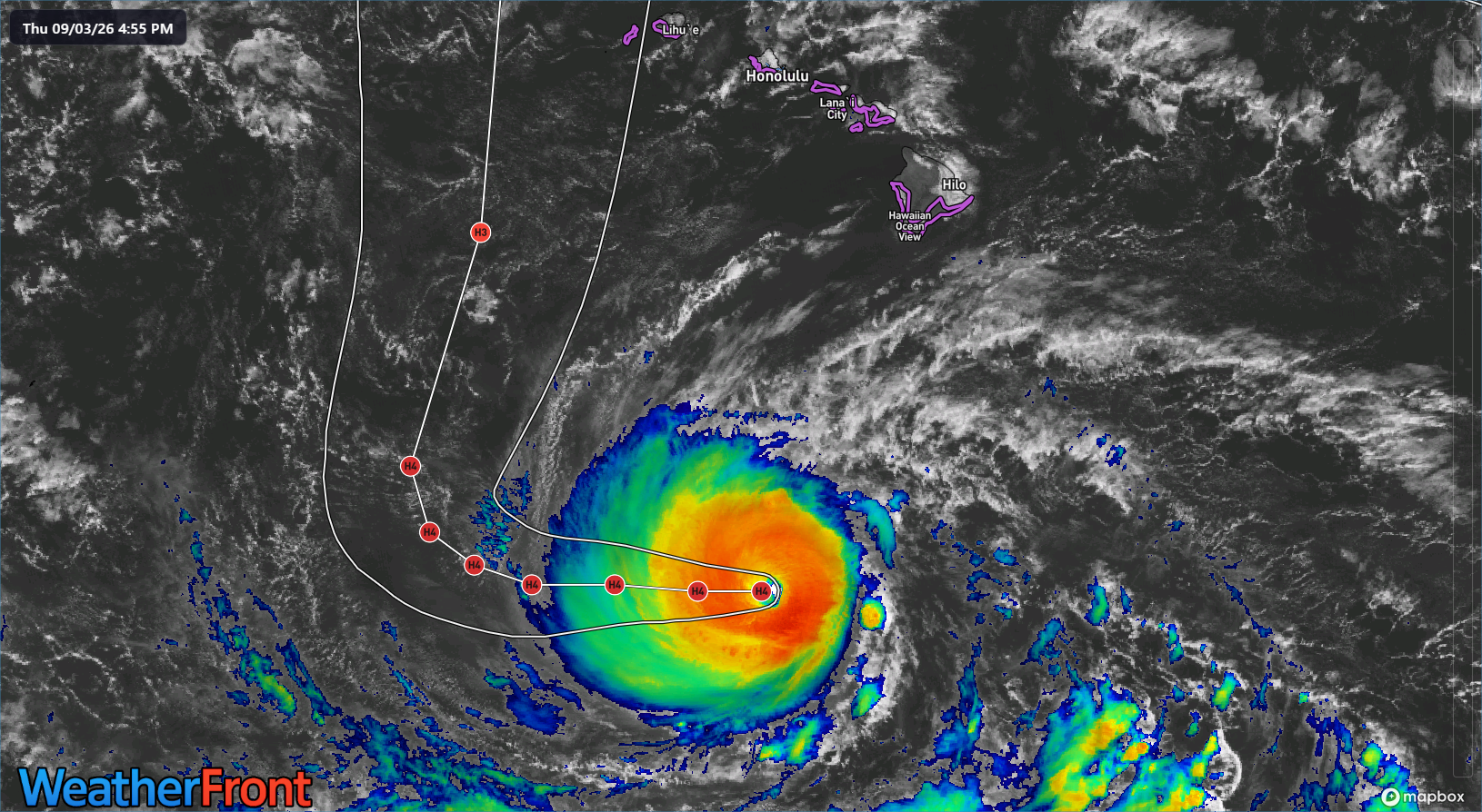
Lowell is currently a powerful hurricane with 140 mph maximum sustained winds. While it is fighting some shear, it’s core looks healthy, and the conditions over the next couple days should support a strong intensity, with occasional fluctuations. The general steering pattern for Lowell is straightforward: It continues west before the ridge controlling that movement gets eroded, which causes Lowell to have an “exit” route north. There are two elements of this that make Lowell’s forecast decidedly not straightforward. First, at what point will the erosion of the ridge occur by an upper low east of Hawaii? That will determine when Lowell slows and turns. Second, how exactly will that upper low dictate Lowell’s trajectory?
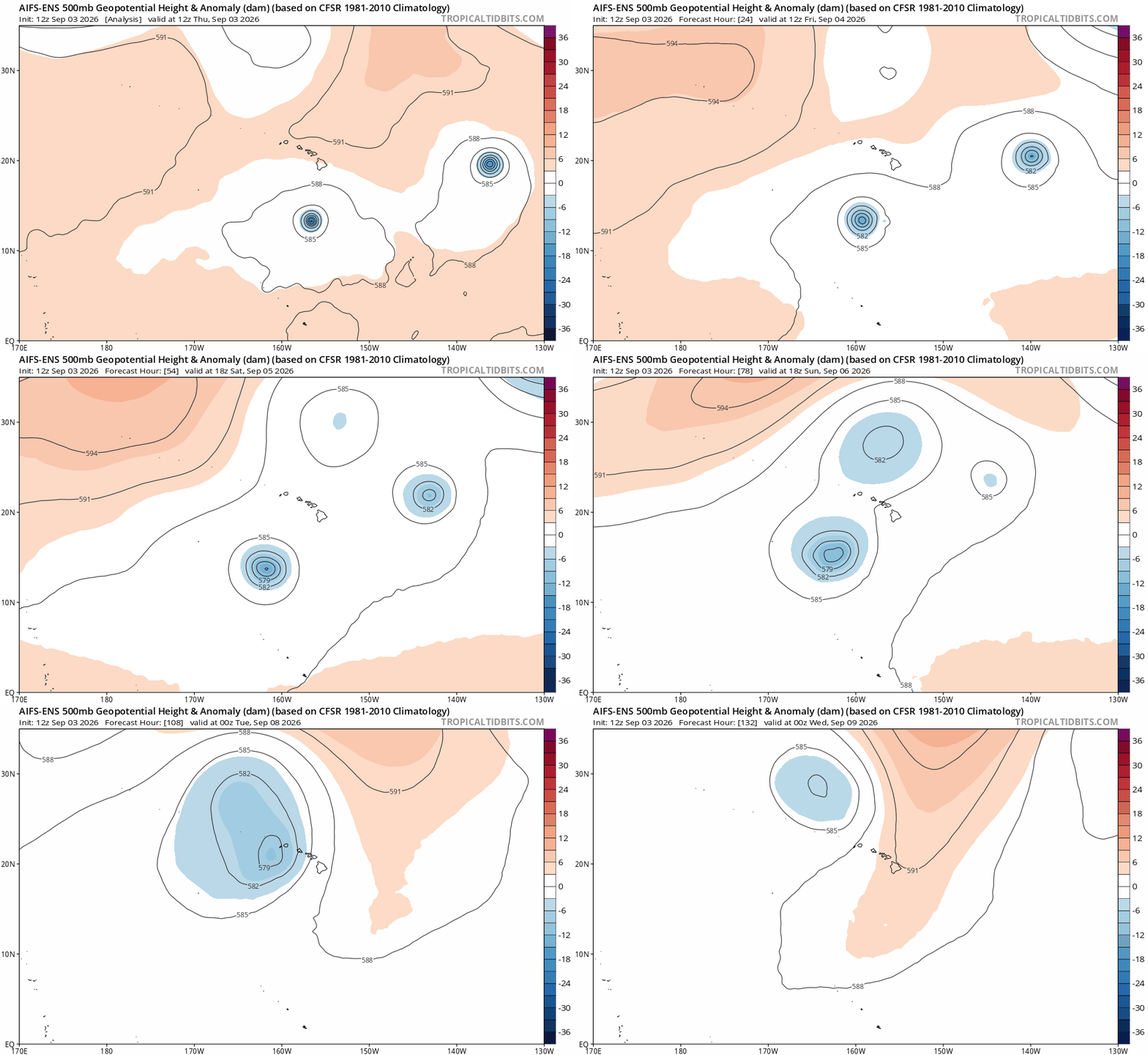
For a time, Lowell may actually turn north and then north northeast, tracking it back toward Hawaiian longitudes. The more aggressively that occurs, the more likely a direct impact will be felt on more of the islands. This is a “capture” scenario we see often in the Atlantic with storms coming out of the Gulf or curving back out to sea in the Atlantic. It’s all about trajectory and timing, and with upper lows, let alone upper lows in the middle of the ocean, it is notoriously challenging to predict specifics.
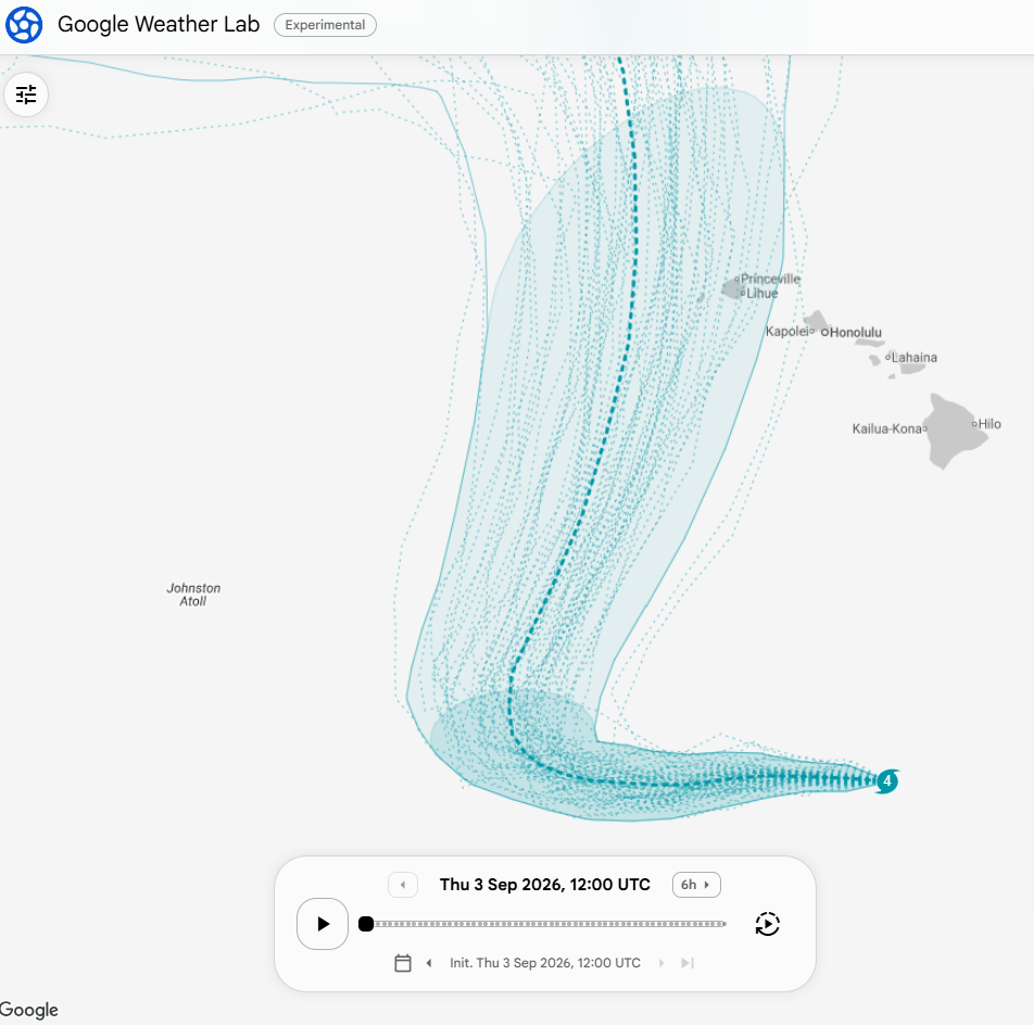
You can see how this manifests in the ensemble spread among Google Deep Mind ensemble members. (This is off their WeatherNext 3 model that they just released to the masses today) Many are west of Hawaii, but several are very close to the westernmost islands. The farther east within that ensemble envelope Lowell tracks, the greater the impact to the Hawaiian Islands.
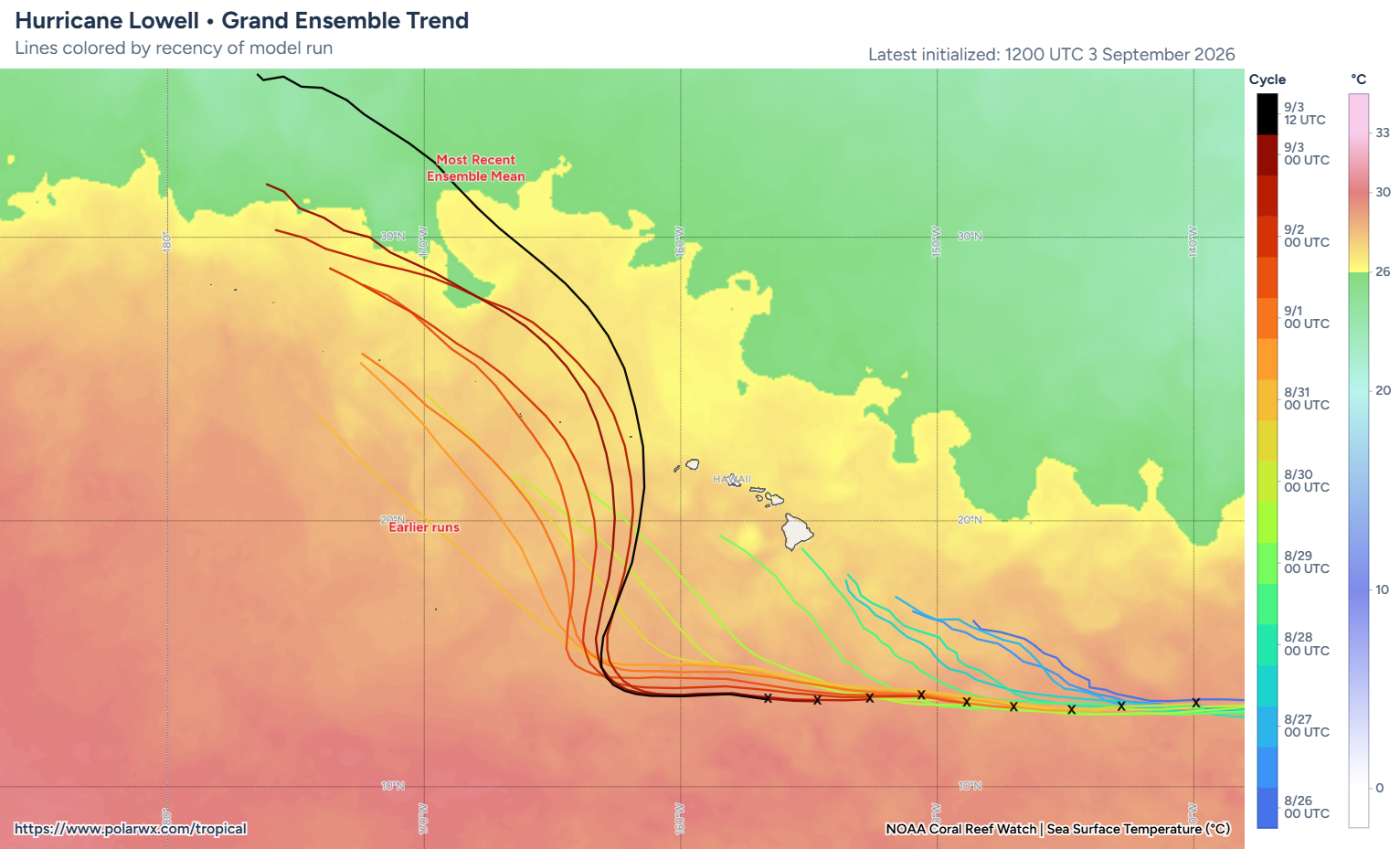
And indeed, we’ve seen other modeling besides Google trend closer and closer to Hawaii the last couple days. The most recent ensemble mean is the closest pass yet.
We know that these impacts, whatever they may be, will likely begin on Monday or early Tuesday sometime. Folks in Hawaii should continue monitoring this forecast closely, as Lowell will likely maintain a good bit of its intensity once up near Hawaii, possibly still even close to major hurricane intensity. It’s going to be an uncomfortable couple days watching this.