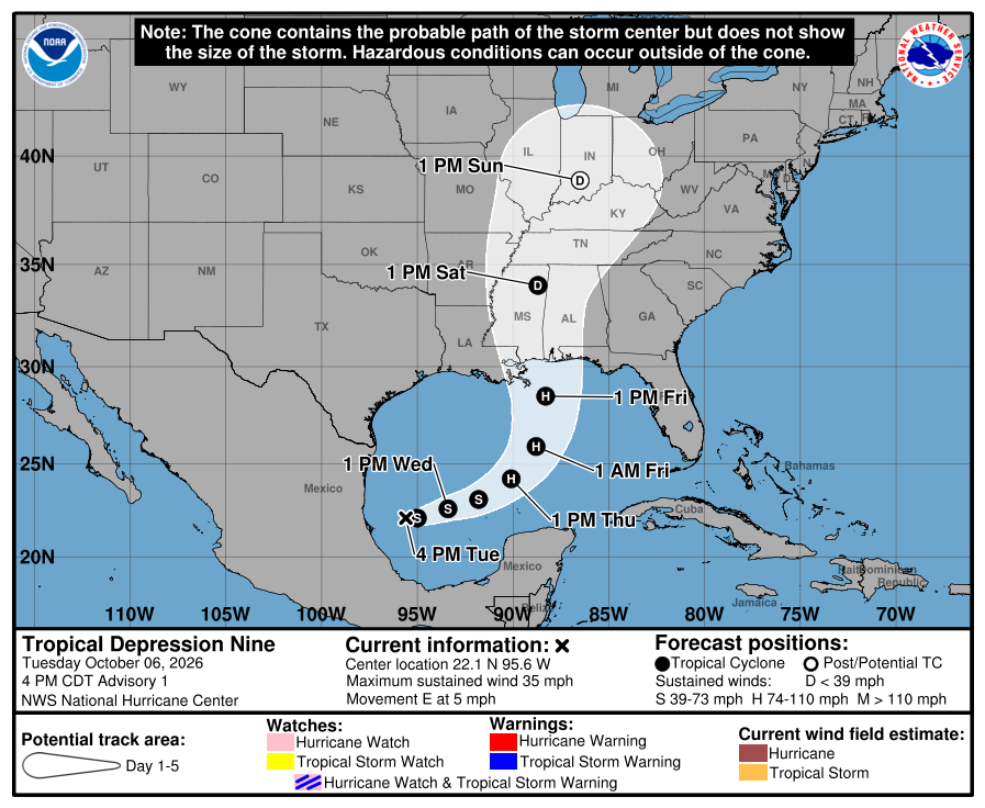
In brief: Invest 92L is now Tropical Depression 9 and likely to become our next named storm, and it has a decent chance to become the season’s first hurricane. The storm is likely to impact the central or eastern Gulf Coast by the weekend, with a focus between Biloxi and Destin, FL right now. The potential exists for a landfalling hurricane or borderline major hurricane by the weekend on the Gulf Coast.
The forecast has slowly come into better view today for Invest 92L, which is now classified as Tropical Depression 9, and it appears, as we have been kind of warning about as a possibility, this one may be a potent one for the Gulf Coast.
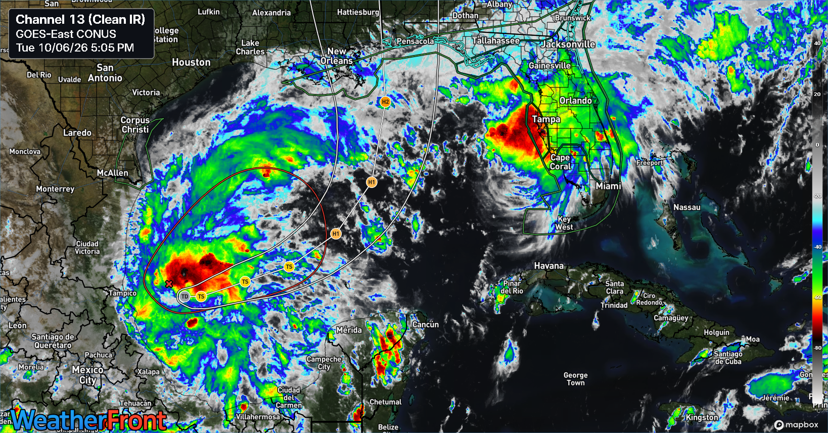
The area of thunderstorms associated with TD 9 looks frazzled but robust this evening. We’re coming out of the daytime minimum for tropical system thunderstorm development and should see the depression begin to perhaps more aggressively produce storms overnight.
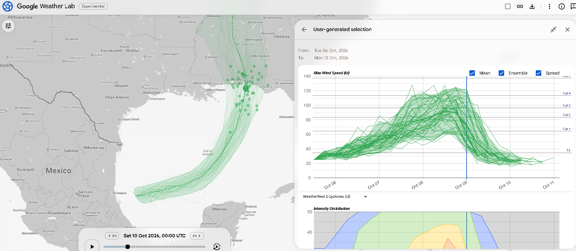
The center of Tropical Depression 9 is expected to drift eastward over the next day and a half as it gradually organizes. From there, we hit the inflection point where this possibly turns into something bigger. And indeed, support for something bigger is increasing today. Let’s start with what we know. We know that some of the best hurricane modeling overall, Google’s AI forecast has bumped up the potential for a hurricane and a major hurricane to approximately 90 and 45 percent respectively.
We know that whatever this is, assuming it generally follows the Google track, will eventually run into a lot of wind shear near the Gulf Coast by Friday night or Saturday, when it presumably approaches landfall.
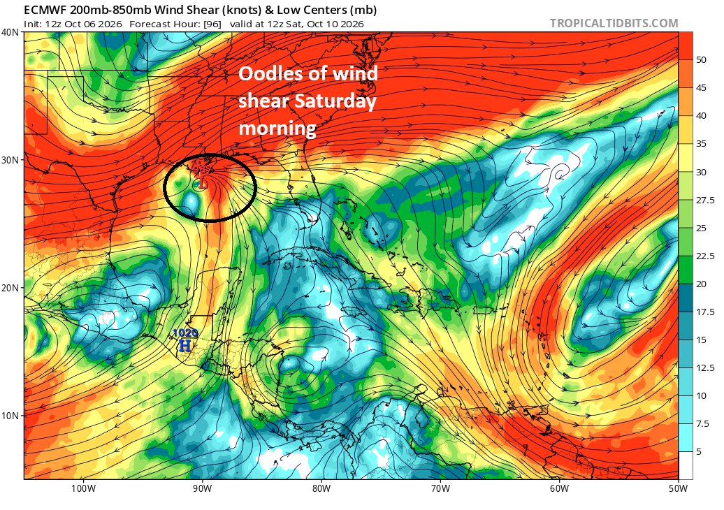
That wind shear should be detrimental to the storm’s intensity (allowing for weakening on approach to the coast), but as I’ve noted on a couple occasions this week, we have seen late season cases where southwest to northeast wind shear can actually help the outflow of a storm and keep it fairly strong. So I think you need to watch this storm and assume it may come in close to peak intensity and prepare around that. That said, while 55 percent of Google’s broader (not operational) 1,000 member ensemble has the storm peaking as a major hurricane, only 22 percent make landfall as such. That seems to suggest it will come in past peak intensity. Still, it is wise to be cautious when any ensemble is flagging 22% of its members making landfall as a major hurricane.
We also know that it’s going to be traversing some of the highest oceanic heat content in the Gulf. While the Gulf itself is below average in terms of heat content (but above average in terms of water temperature), where this is likely to track will hit some of the most heat-rich water of the Gulf.
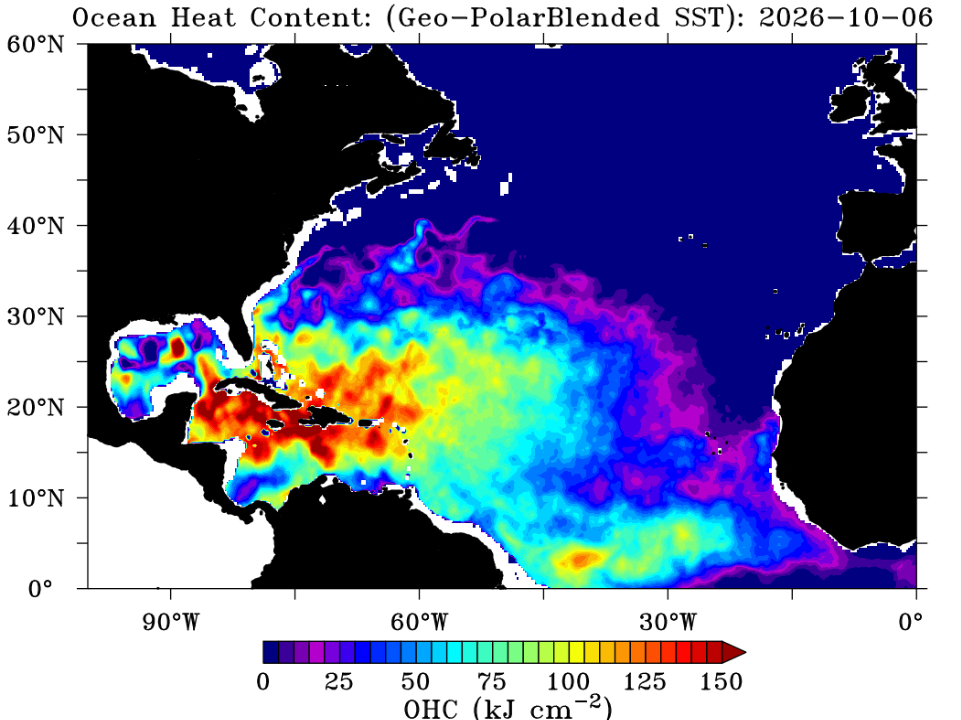
It won’t linger long over that patch of water, so it’s unlikely to be super meaningful, but it could be enough to tip the scales one way or another from tropical storm to hurricane or hurricane to major hurricane depending on the storm’s evolution.
We know a boatload of moisture is headed for the Gulf.
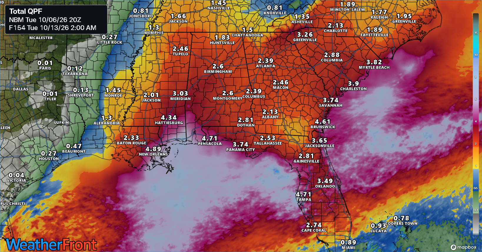
Rain totals aren’t eye popping, but they are over a broad area. Flash flooding is likely to be an issue in spots along the Gulf Coast, as well as inland.
We know that dry air could have a big impact on the storm’s western flank.
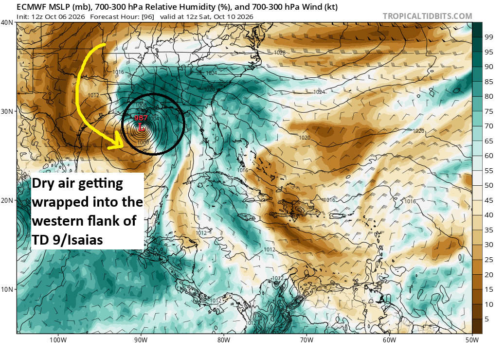
As the storm comes north and pulls in much drier, autumn air southward across Texas and Louisiana and into the western Gulf, we could see it begin to eat away at the western semicircle of the storm, and it’s possible we end up with a sloppy hurricane that has much greater impacts on the east side than the west, even more than usual.
We also know that this is probably going to lead to a bit of a potent setup for strong to severe storms in the Southeast after coming ashore. While details are not going to be worked out for a few days yet, the SPC did mention the potential for expanding severe risks Sunday and Monday in their discussion today.
So what does this all equate to?
- Tropical development is likely in the Gulf, with advisories almost certain to begin tonight or tomorrow morning.
- The system we are watching is likely to become a tropical storm, a strong tropical storm, and probably a hurricane at some point.
- There is about a 50/50 shot that this becomes a major hurricane over the open Gulf before the storm likely weakens a bit at landfall. (However, the risk of the storm making landfall at peak intensity is not zero).
- Heavy rain is likely along the Gulf Coast and inland, along with the potential for strong to severe storms Sunday and Monday across the Eastern U.S.
- The main target area for landfall appears to be between New Orleans and Panama City, FL, with a slight edge on areas between Biloxi and Destin.
- The storm may have exaggerated impacts on the east side of the center versus the west, meaning landfall, while not the only thing that matters, will be an important delineation for this storm’s worst impacts.
- The timing appears to be between Friday night and Sunday morning for the worst impacts and landfall.
Folks on the Gulf Coast, particularly from Biloxi through Destin really should be preparing now for the potential of a hurricane by Friday night. While details and specifics will change in the coming days, there’s a lot we can see already that’s concerning enough to make it make sense to begin to make preparations. More to come.
Let’s get this out of the way now: The next storm’s name is Isaias, a name that is recycled from the 2020 list, which did a lot of damage on the East Coast, and in some circles was a surprise that it was not retired. It replaced Hurricane Ike on the lists in 2014. It is pronounced “ees-ah-EE-ahs.”